oth intruded by granitic plutons and younger basic rocks, constitute the bulk of the exposed rocks inthe northern and eastern part of the district. Exposed along the southern rims of the plateau is anear complete sequence of Tertiary sediments overlying the volcanic suite of Sylhet traps, equivalentin age to the Deccan traps of western peninsular India.Thin seams of low ash, high sulphur coal, occurring fairly extensively on the lower Tertiarysediments and high grade fossiliferous limestones overlying these are the major minerals occurringin the district. The southern plank of the plateau is prone to landslides.2.7 SOCIO‐ECONOMIC FEATURESSo far as we have delved deep into the matter of the economic status of Meghalaya as a whole and<strong>East</strong> <strong>Khasi</strong> <strong>Hills</strong> in particular in various aspects such as agriculture and its allied activities, industries,mining, banking, finance, water supply, electricity, road and transportation, post andtelecommunication, education and health, literacy and employment, it has been noticed that thoughpost and telecommunications have developed, with the advent of computers and mobile phones,enrolment of employees in Government has decreased in the past ten years and a saturation pointhas been reached.It must be noted that unemployment is not only an economic problem but also a social issue, whichdisturbs the pace of development and peace in the society. Literacy and education are regarded astwo important criteria that reflect the progress of any individual at any level.According to the Census report of the Government of India, 2001, <strong>East</strong> <strong>Khasi</strong> <strong>Hills</strong> District, has shownthe highest rate of literate persons in the state with 74.74%.Big industries are scarce, in fact, absent in <strong>East</strong> <strong>Khasi</strong> <strong>Hills</strong> District which partially or wholly results inlow per capita consumption of electricity annually. Industrial backwardness may also be attributed tovarious factors, geographical and non‐ geographical that might have hindered the progress of thissector.Road transport has become one of the important infrastructural needs of the people in order toenhance productive activities and the well being of the society as a whole. Road transport is thelifeline of the state as far as its economy is concerned. There are no railway lines to and in Meghalayaas a whole and <strong>East</strong> <strong>Khasi</strong> <strong>Hills</strong> in particular. Although air transport is available in the state, it isperhaps still considered a luxury to the populace.District Disaster Management Plan, <strong>East</strong> <strong>Khasi</strong> <strong>Hills</strong> District Page 10
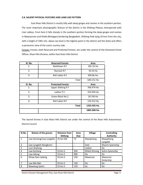
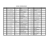
2.8. SALIENT PHYSICAL FEATURES AND LAND USE PATTERN<strong>East</strong> <strong>Khasi</strong> <strong>Hills</strong> District is mostly hilly with deep gorges and ravines in the southern portion.The most important physiographic feature of the district is the Shillong Plateau interspersed withriver valleys. From here it falls sharply in the southern portion forming the deep gorges and ravinesin Mawsynram and Shella‐Bholaganj bordering Bangladesh. Shillong Peak lying 10 kms from the city,with a height of 1961 mts. above sea level is the highest point in the district and the State and offersa panoramic view of the scenic country side.Forests: Forests, both Reserved and Protected Forests, are under the control of the Divisional ForestOfficer, <strong>Khasi</strong> <strong>Hills</strong> Division, within <strong>East</strong> <strong>Khasi</strong> <strong>Hills</strong> District.Sl. No. Reserved Forests Area1. Raitkhwan R.F 391.33 Ha2. Shyrwat R.F 44.16 Ha3. Rait Laban R.F 204.66 Ha.Total640.151 HaSl. No. Protected Forests Area1. Upper Shillong P.F 766.474 Ha2. Laitkor P.F. 324.920 Ha3. Green Block No.2 20.749 Ha4. Rait Laban R.F 133.312 HaTotal1225.455 Ha.1865.606 Ha.The Sacred Groves in <strong>East</strong> <strong>Khasi</strong> <strong>Hills</strong> District are under the control of the <strong>Khasi</strong> <strong>Hills</strong> AutonomousDistrict CouncilSl.No. Names of the groves Distance fromShillongArea(ha)Village ControllingAuthority1 Law Kyntang/Law Lyngdoh 25 km SW 75 Mawphlang MawphlangLyngdoh2 Law Lyngdoh Nongkrem ‐ ‐ Smit Khyrim Syiemship3 Lum Shyllong ‐ ‐ Laitkor Do4 Law Kyntang 53 km S 350 Khlieh Shnong Sohra Syiemship5 Law Adong 53 km S 900 Do Do6 Khlaw Ram Jadong 55 km S 150 Mawsmai MawsmaiSirdarship7 Law Blei Bah 55 km S 120 Do Do8 Mawlong Syiem 55 km S 120 do DoDistrict Disaster Management Plan, <strong>East</strong> <strong>Khasi</strong> <strong>Hills</strong> District Page 11