Table of Contents - SRK Consulting
Table of Contents - SRK Consulting
Table of Contents - SRK Consulting

You also want an ePaper? Increase the reach of your titles
YUMPU automatically turns print PDFs into web optimized ePapers that Google loves.
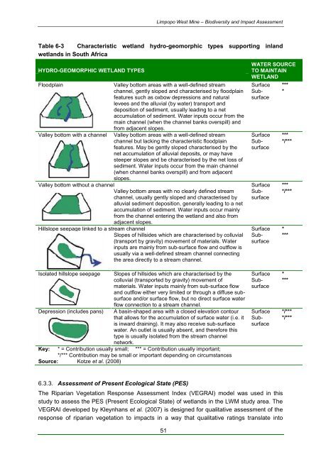
Limpopo West Mine – Biodiversity and Impact Assessment<strong>Table</strong> 6-3 Characteristic wetland hydro-geomorphic types supporting inlandwetlands in South AfricaHYDRO-GEOMORPHIC WETLAND TYPESFloodplainValley bottom with a channelValley bottom areas with a well-defined streamchannel, gently sloped and characterised by floodplainfeatures such as oxbow depressions and naturallevees and the alluvial (by water) transport anddeposition <strong>of</strong> sediment, usually leading to a netaccumulation <strong>of</strong> sediment. Water inputs occur from themain channel (when the channel banks overspill) andfrom adjacent slopes.Valley bottom areas with a well-defined streamchannel but lacking the characteristic floodplainfeatures. May be gently sloped characterised by thenet accumulation <strong>of</strong> alluvial deposits, or may havesteeper slopes and be characterised by the net loss <strong>of</strong>sediment. Water inputs occur from the main channel(when channel banks overspill) and from adjacentslopes.WATER SOURCETO MAINTAINWETLANDSurface ***Subsurface*Surface ***Subsurface*/***Valley bottom without a channel Surface ***Valley bottom areas with no clearly defined streamchannel, usually gently sloped and characterised byalluvial sediment deposition, generally leading to a netaccumulation <strong>of</strong> sediment. Water inputs occur mainlyfrom the channel entering the wetland and also fromadjacent slopes.Subsurface*/***Hillslope seepage linked to a stream channel Surface *Slopes <strong>of</strong> hillsides which are characterised by colluvial(transport by gravity) movement <strong>of</strong> materials. Waterinputs are mainly from sub-surface flow and outflow isusually via a well-defined stream channel connectingthe area directly to a stream channel.Subsurface***Isolated hillslope seepage Slopes <strong>of</strong> hillsides which are characterised by thecolluvial (transported by gravity) movement <strong>of</strong>materials. Water inputs mainly from sub-surface flowand outflow either very limited or through a diffuse subsurfaceand/or surface flow, but no direct surface waterflow connection to a stream channel.Depression (includes pans) A basin-shaped area with a closed elevation contourthat allows for the accumulation <strong>of</strong> surface water (i.e. itis inward draining). It may also receive sub-surfacewater. An outlet is usually absent, and therefore thistype is usually isolated from the stream channelnetwork.Key: * = Contribution usually small; *** = Contribution usually important;*/*** Contribution may be small or important depending on circumstancesSource: Kotze et al. (2008)Surface *Subsurface***Surface */***Subsurface*/***6.3.3. Assessment <strong>of</strong> Present Ecological State (PES)The Riparian Vegetation Response Assessment Index (VEGRAI) model was used in thisstudy to assess the PES (Present Ecological State) <strong>of</strong> wetlands in the LWM study area. TheVEGRAI developed by Kleynhans et al. (2007) is designed for qualitative assessment <strong>of</strong> theresponse <strong>of</strong> riparian vegetation to impacts in a way that qualitative ratings translate into51