- Page 3 and 4: Comprehensive PlanTown of Westerly,
- Page 5 and 6: The Westerly Comprehensive PlanCont
- Page 7 and 8: 1.0 IntroductionWelcome to the Comp
- Page 9 and 10: The Westerly Comprehensive Plan1.3
- Page 11 and 12: The Westerly Comprehensive Plan1.4
- Page 13 and 14: Perhaps more than anything else, aC
- Page 15 and 16: The Westerly Comprehensive Planmaki
- Page 17: ELM STPawcatuck RiverCONNECTICUTCAN
- Page 21 and 22: The Westerly Comprehensive Plan2.4
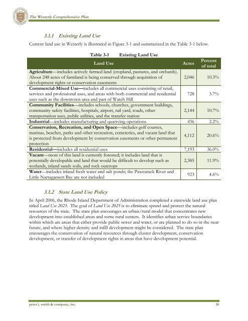
- Page 27 and 28: The Westerly Comprehensive Plan3.1.
- Page 29: CANAL STPawcatuck RiverMil e BrookA
- Page 32 and 33: The Westerly Comprehensive Plan•
- Page 34 and 35: The Westerly Comprehensive PlanReso
- Page 37 and 38: The Westerly Comprehensive Plan3.4.
- Page 39 and 40: The Westerly Comprehensive PlanThe
- Page 41: CANAL STCONNECTICUTUPPER CANAL STMA
- Page 44 and 45: The Westerly Comprehensive PlanTabl
- Page 46 and 47: The Westerly Comprehensive Planall
- Page 48 and 49: The Westerly Comprehensive Plan3.8.
- Page 50 and 51: The Westerly Comprehensive Plan5. L
- Page 52 and 53: The Westerly Comprehensive Planappr
- Page 54 and 55: The Westerly Comprehensive PlanThe
- Page 56 and 57: The Westerly Comprehensive Planland
- Page 58 and 59: The Westerly Comprehensive PlanThe
- Page 60 and 61: The Westerly Comprehensive PlanWhen
- Page 62 and 63: The Westerly Comprehensive Plan•
- Page 65 and 66: The Westerly Comprehensive Plan4.4.
- Page 67 and 68: The Westerly Comprehensive Plan•
- Page 69 and 70: The Westerly Comprehensive Planappr
- Page 71 and 72: 5.1 Introduction5.0 Implementation
- Page 73 and 74:
The Westerly Comprehensive PlanActi
- Page 75 and 76:
The Westerly Comprehensive PlanObje
- Page 77 and 78:
The Westerly Comprehensive PlanGOAL
- Page 79 and 80:
The Westerly Comprehensive PlanObje
- Page 81 and 82:
The Westerly Comprehensive PlanGOAL
- Page 83 and 84:
The Westerly Comprehensive PlanTabl
- Page 85 and 86:
The Westerly Comprehensive PlanNo.
- Page 87 and 88:
The Westerly Comprehensive PlanGOAL
- Page 89 and 90:
The Westerly Comprehensive PlanGOAL
- Page 91 and 92:
The Westerly Comprehensive PlanGOAL
- Page 93 and 94:
The Westerly Comprehensive PlanGOAL
- Page 97 and 98:
Comprehensive PlanTown of Westerly,
- Page 99 and 100:
The Westerly Comprehensive PlanCont
- Page 101 and 102:
The Westerly Comprehensive PlanTabl
- Page 103 and 104:
Introduction to the Comprehensive P
- Page 105 and 106:
Appendix I - Inventory1.0 Existing
- Page 107 and 108:
The Westerly Comprehensive PlanAgri
- Page 109:
ELM STCANAL STCANAL STCONNECTICUTRA
- Page 112 and 113:
The Westerly Comprehensive PlanThe
- Page 114 and 115:
The Westerly Comprehensive PlanHigh
- Page 116 and 117:
The Westerly Comprehensive PlanOffi
- Page 119 and 120:
2.1 Overview2.0 HousingThe availabi
- Page 121 and 122:
The Westerly Comprehensive PlanClar
- Page 123 and 124:
The Westerly Comprehensive PlanTabl
- Page 125 and 126:
The Westerly Comprehensive PlanHome
- Page 127 and 128:
The Westerly Comprehensive PlanA su
- Page 129 and 130:
3.1 Introduction3.0 Economic Vitali
- Page 131 and 132:
The Westerly Comprehensive PlanLawr
- Page 133 and 134:
The Westerly Comprehensive PlanRecr
- Page 135 and 136:
The Westerly Comprehensive PlanLoca
- Page 137 and 138:
The Westerly Comprehensive Plan3.5.
- Page 139 and 140:
The Westerly Comprehensive Plan3.5.
- Page 141 and 142:
4.1 Physical Setting4.0 Natural Res
- Page 143 and 144:
The Westerly Comprehensive PlanWate
- Page 145 and 146:
The Westerly Comprehensive PlanBrad
- Page 147 and 148:
The Westerly Comprehensive PlanChap
- Page 149 and 150:
The Westerly Comprehensive PlanGene
- Page 151 and 152:
The Westerly Comprehensive Planordi
- Page 153 and 154:
The Westerly Comprehensive PlanReso
- Page 155 and 156:
The Westerly Comprehensive Plan4.6
- Page 157 and 158:
The Westerly Comprehensive PlanThe
- Page 159 and 160:
The Westerly Comprehensive PlanWinn
- Page 161 and 162:
The Westerly Comprehensive Planrive
- Page 163:
Pawcatuck RiverMil e BrookTomaquag
- Page 167:
CANAL STCONNECTICUTUPPER CANAL STMA
- Page 171:
Pawcatuck RiverMil e BrookTomaquag
- Page 174 and 175:
The Westerly Comprehensive PlanIn 2
- Page 176 and 177:
The Westerly Comprehensive Plan2008
- Page 178 and 179:
The Westerly Comprehensive PlanA $3
- Page 180 and 181:
The Westerly Comprehensive PlanAt t
- Page 182 and 183:
The Westerly Comprehensive Plan5.5
- Page 184 and 185:
The Westerly Comprehensive Plansuch
- Page 186 and 187:
The Westerly Comprehensive Planrefe
- Page 188 and 189:
The Westerly Comprehensive Planlibr
- Page 190 and 191:
The Westerly Comprehensive Planpete
- Page 193:
CANAL STCONNECTICUTPS#2UPPER CANAL
- Page 196 and 197:
The Westerly Comprehensive Plan6.1.
- Page 198 and 199:
The Westerly Comprehensive Planof R
- Page 200 and 201:
The Westerly Comprehensive Planthe
- Page 202 and 203:
The Westerly Comprehensive PlanPark
- Page 204 and 205:
The Westerly Comprehensive PlanPark
- Page 206 and 207:
The Westerly Comprehensive PlanQuon
- Page 208 and 209:
The Westerly Comprehensive PlanOthe
- Page 210 and 211:
The Westerly Comprehensive PlanIn W
- Page 212 and 213:
The Westerly Comprehensive PlanTabl
- Page 214 and 215:
The Westerly Comprehensive Plan7.3.
- Page 216 and 217:
The Westerly Comprehensive Plan7.4
- Page 218 and 219:
The Westerly Comprehensive PlanReco
- Page 220 and 221:
The Westerly Comprehensive PlanTher
- Page 222 and 223:
The Westerly Comprehensive Planprov
- Page 224 and 225:
The Westerly Comprehensive Planpete
- Page 226 and 227:
The Westerly Comprehensive Plano Ro
- Page 228 and 229:
The Westerly Comprehensive Planwhil
- Page 230 and 231:
The Westerly Comprehensive Planexpe
- Page 232 and 233:
The Westerly Comprehensive Plan9.3.
- Page 234 and 235:
The Westerly Comprehensive Planof m
- Page 236 and 237:
The Westerly Comprehensive Plan9.4.
- Page 238 and 239:
The Westerly Comprehensive Plan9.4.
- Page 240:
The Westerly Comprehensive Plan9.4.
- Page 244 and 245:
The Westerly Comprehensive PlanGoal
- Page 246 and 247:
The Westerly Comprehensive Plan9.5
- Page 248 and 249:
The Westerly Comprehensive PlanTabl
- Page 250 and 251:
The Westerly Comprehensive Plan9.5.
- Page 252 and 253:
The Westerly Comprehensive PlanThe
- Page 254 and 255:
The Westerly Comprehensive PlanThe