

® Ontario ontario institute of pedology - Agriculture and Agri-Food ...
® Ontario ontario institute of pedology - Agriculture and Agri-Food ...
® Ontario ontario institute of pedology - Agriculture and Agri-Food ...

Create successful ePaper yourself
Turn your PDF publications into a flip-book with our unique Google optimized e-Paper software.
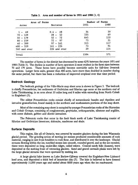
Table 3.Area <strong>and</strong> number <strong>of</strong> farmsin 1951 <strong>and</strong> 1988 (1, 4)AcresArea <strong>of</strong>FarmsHectaresNumber <strong>of</strong>1951Farms19881 - 69 0 .4 - 28 34 3970 - 129 28 - 52 335 6930 - 179 52 - 72 645 11080 - 239 72 - 97 73 3140 - 399 97 - 161 315 117400 - 559 161 - 226 73 91560 <strong>and</strong> over 226 <strong>and</strong> over 29 114Total 1504 571The number <strong>of</strong> farms in the district has decreased by some 62% between the years 1951 <strong>and</strong>1988 (Table 3). The decline in number <strong>of</strong> farm operators is most evident in the farm sizes between70 <strong>and</strong> 179 acres. These farms have possibly become nonviable units for full-time livestockoperations . Larger farm units, greater than 400 acres, have more than doubled in number duringthe same period, but there has been a reduction <strong>of</strong> improved cropl<strong>and</strong> over that time period .Bedrock GeologyThe bedrock geology <strong>of</strong> the Ville-Marie map sheet area is shown in Figure 3 . The bedrockis chiefly Precambrian, but sediments <strong>of</strong> Ordivician <strong>and</strong> Silurian age occur at the northern end <strong>of</strong>Lake Timiskaming, in an area about 33 miles long <strong>and</strong> 8 miles wide extending from North Cobaltto Englehart (5) .The oldest Precambrian rocks consist chiefly <strong>of</strong> metavolcanic basalts <strong>and</strong> rhyolites <strong>and</strong>intrusive granodiorites, found mainly in the northern <strong>and</strong> southeastern portions <strong>of</strong> the map sheet .Most <strong>of</strong> the remaining map sheet is occupied by younger Precambrian rocks <strong>of</strong> the Huronian<strong>and</strong> Cobalt Groups, consisting <strong>of</strong> conglomerate, greywacke, orthoquartzite, siltstone <strong>and</strong> argillite,with some diabase, gabbro <strong>and</strong> diorite intrusions .The Paleozoic rocks that occur in the fault block north <strong>of</strong> Lake Timiskaming consist <strong>of</strong>Silurian <strong>and</strong> Ordivician limestone, dolomite, s<strong>and</strong>stone <strong>and</strong> shale.Surface DepositsThis region, like all <strong>of</strong> <strong>Ontario</strong>, was covered by massive glaciers during the late Wisconsinglacial period . The grinding action <strong>of</strong> moving ice masses produced considerable amounts <strong>of</strong> rockmaterial, ranging in size from boulders to rock flour, <strong>and</strong> distributed it over the l<strong>and</strong>scape. Glacialstreams flowing within the ice, tumbled stones into smooth, rounded gravel, <strong>and</strong> as the ice receded,these were deposited as long, snake-like ridges, called eskers . Conical s<strong>and</strong>y hills (kames), weredeposited at the melting front <strong>of</strong> retreating glaciers . S<strong>and</strong> <strong>and</strong> gravel outwash plains were left bythe large glacial streams that were spawned by melting ice .A large glacial lake known as Lake Barlow-Ojibway covered the Englehart-New Liskeardl<strong>and</strong> area, <strong>and</strong> deposited a thick bed <strong>of</strong> lacustrine clay (5) . The lake is believed to have formedapproximately 11,000 years ago <strong>and</strong> ended about 8000 years ago when the ice readvanced .


