

® Ontario ontario institute of pedology - Agriculture and Agri-Food ...
® Ontario ontario institute of pedology - Agriculture and Agri-Food ...
® Ontario ontario institute of pedology - Agriculture and Agri-Food ...

Create successful ePaper yourself
Turn your PDF publications into a flip-book with our unique Google optimized e-Paper software.
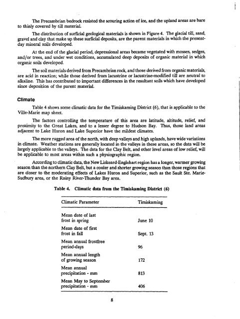
The Precambrian bedrock resisted the scouring action <strong>of</strong> ice, <strong>and</strong> the upl<strong>and</strong> areas are bareto thinly covered by till material.The distribution <strong>of</strong> surficial geological materials is shown in Figure 4 . The glacial till, s<strong>and</strong>,gravel <strong>and</strong> clay that make up these surficial deposits, are the parent materials in which the presentdaymineral soils developed .At the end <strong>of</strong> the glacial period, depressional areas became vegetated with mosses, sedges,<strong>and</strong>/or trees, <strong>and</strong> under wet conditions, accumulated deep deposits <strong>of</strong> organic material in whichorganic soils developed .The soil materials derived from Precambrian rock, <strong>and</strong> those derived from organic materials,are acid in reaction ; while those derived from lacustrine or lacustrine-modified till are neutral toalkaline. This has contributed to important differences in the resultant soils which have developedsince deposition <strong>of</strong> the parent material .ClimateTable 4 shows some climatic data for the Timiskaming District (6), that is applicable to theVille-Marie map sheet .The factors controlling the temperature <strong>of</strong> this area are latitude, altitude, relief, <strong>and</strong>proximity to the Great Lakes, <strong>and</strong> to a lesser degree to Hudson Bay. Thus, those l<strong>and</strong> areasadjacent to Lake Huron <strong>and</strong> Lake Superior have the mildest climates .The more rugged area <strong>of</strong> the north, with deep valleys <strong>and</strong> high upl<strong>and</strong>s, have wide variationsin climate . Weather stations are generally located in the valleys in these areas, so the data will belargely applicable to the valleys . The data for the Clay Belt, <strong>and</strong> other level areas <strong>of</strong> low relief, willbe applicable to most areas within such a physiographic region .According to climatic data, the New Liskeard-Englehart region has a longer, warmer growingseason than the northern Clay Belt, but a cooler <strong>and</strong> shorter growing season than those regions thatare closer to the moderating effects <strong>of</strong> Lakes Huron <strong>and</strong> Superior, such as the Sault Ste. Marie-Sudbury area, or the Rainy River-Thunder Bay area.Table 4. Climatic data from the Timiskaming District (6)Climatic ParameterTimiskamingMean date <strong>of</strong> lastfrost in spring June 10Mean date <strong>of</strong> firstfrost in fall Sept . 13Mean annual frostfreeperiod-days 96Mean annual length<strong>of</strong> growing season 172Mean annualprecipitation - mm 813Mean May to Septemberprecipitation - mm 406


