

Mapping of Drought Areas over India - (IMD), Pune
Mapping of Drought Areas over India - (IMD), Pune
Mapping of Drought Areas over India - (IMD), Pune

You also want an ePaper? Increase the reach of your titles
YUMPU automatically turns print PDFs into web optimized ePapers that Google loves.
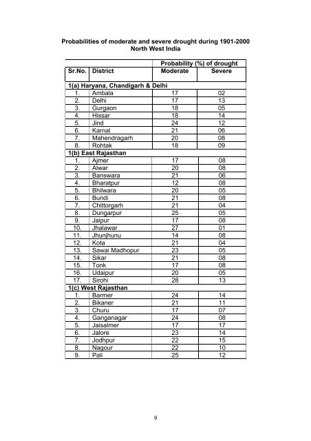
Probabilities <strong>of</strong> moderate and severe drought during 1901-2000North West <strong>India</strong>Probability (%) <strong>of</strong> droughtSr.No. District Moderate Severe1(a) Haryana, Chandigarh & Delhi1. Ambala 17 022. Delhi 17 133. Gurgaon 18 054. Hissar 18 145. Jind 24 126. Karnal 21 067. Mahendragarh 20 088. Rohtak 18 091(b) East Rajasthan1. Ajmer 17 082. Alwar 20 083. Banswara 21 064. Bharatpur 12 085. Bhilwara 20 056. Bundi 21 087. Chittorgarh 21 048. Dungarpur 25 059. Jaipur 17 0810. Jhalawar 27 0111. Jhunjhunu 14 0812. Kota 21 0413. Sawai Madhopur 23 0514. Sikar 21 0815. Tonk 17 0816. Udaipur 20 0517. Sirohi 28 131(c) West Rajasthan1. Barmer 24 142. Bikaner 21 113. Churu 17 074. Ganganagar 24 085. Jaisalmer 17 176. Jalore 23 147. Jodhpur 22 158. Nagour 22 109. Pali 25 129


