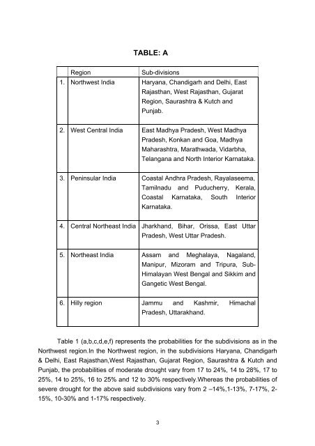
TABLE: ARegionSub-divisions1. Northwest <strong>India</strong> Haryana, Chandigarh and Delhi, EastRajasthan, West Rajasthan, GujaratRegion, Saurashtra & Kutch andPunjab.2. West Central <strong>India</strong> East Madhya Pradesh, West MadhyaPradesh, Konkan and Goa, MadhyaMaharashtra, Marathwada, Vidarbha,Telangana and North Interior Karnataka.3. Peninsular <strong>India</strong> Coastal Andhra Pradesh, Rayalaseema,Tamilnadu and Puducherry, Kerala,Coastal Karnataka, South InteriorKarnataka.4. Central Northeast <strong>India</strong> Jharkhand, Bihar, Orissa, East UttarPradesh, West Uttar Pradesh.5. Northeast <strong>India</strong> Assam and Meghalaya, Nagaland,Manipur, Mizoram and Tripura, Sub-Himalayan West Bengal and Sikkim andGangetic West Bengal.6. Hilly region Jammu and Kashmir, HimachalPradesh, Uttarakhand.Table 1 (a,b,c,d,e,f) represents the probabilities for the subdivisions as in theNorthwest region.In the Northwest region, in the subdivisions Haryana, Chandigarh& Delhi, East Rajasthan,West Rajasthan, Gujarat Region, Saurashtra & Kutch andPunjab, the probabilities <strong>of</strong> moderate drought vary from 17 to 24%, 14 to 28%, 17 to25%, 14 to 25%, 16 to 25% and 12 to 30% respectively.Whereas the probabilities <strong>of</strong>severe drought for the above said subdivisions vary from 2 –14%,1-13%, 7-17%, 2-15%, 10-30% and 1-17% respectively.3
Table 2 (a,b,c,d,e,f,g,h) represents the probabilities for the West Centralregion. In West Central <strong>India</strong>, in the subdivisions, East Madhya.Pradesh, WestMadhya Pradesh, Konkan and Goa, Madhya Maharashtra, Marathwada, Vidarbha,Telangana and North Interior Karnataka, the probabilities <strong>of</strong> moderate drought varyfrom 06-22%,12-25%, 8-16%, 5-19%, 15-26%, 11-20%,10-24% and 9-28%respectively. The probabilities <strong>of</strong> severe drought for the same subdivisions as abovevary from 1-4%, 1-8%, 1 -4%, 1-6%, 2-6%, 1-2% 1-3% and 1-6% respectively.Table 3 (a,b,c,d,e,f) represents the probabilities for the Peninsular region. InPeninsular region, in the sub-divisions Coastal Andhra Pradesh, Rayalaseema,Tamilnadu and Puducherry, Coastal Karnataka, South Interior Karnataka and Kerala,the probabilities <strong>of</strong> moderate drought vary from 6-22%, 9-24%, 8-27%, 3-4%, 7-27%,5-25% respectively. The probabilities <strong>of</strong> severe drought for the above sub-divisionsvary from 1-3%, 1-4%, 1-18%, 0-1%, 1-3% and 1-3% respectively.Table 4(a,b,c,d,e) represents the probabilities in the Central Northeast region.In Central Northeast region, in the subdivisions Orissa, Jharkhand, Bihar, East UttarPradesh and West Uttar Pradesh the probabilities <strong>of</strong> moderate drought vary from 6-21%, 6-13%, 6-19%, 10-37%, 7-29% respectively.The probabilities <strong>of</strong> severe droughtfor the above sub-divisions except Jharkhand vary from 1-3%, 1-2%, 1-5%, 1-10%respectively. Jharkhand has experienced no severe drought.Table 5(a,b,c,d) represents the probabilities in North-east region. In the Northeastregion, in the sub-divisions Assam and Meghalaya, Nagaland, Manipur,Mizoram and Tripura, Sub-Himalayan West Bengal & Sikkim and Gangetic WestBengal the probabilities <strong>of</strong> moderate drought vary from 1-14%, 7-14%, 6-16%, 8-26% respectively.The probabilities <strong>of</strong> severe drought for the above said sub-divisionsvary from 1-3%, 1-2%, 1-3%, 0- 3% respectively.Table 6 (a,b,c) represents the probabilities in the hilly regions <strong>of</strong> <strong>India</strong>. In thehilly region, the sub-divisions Jammu-Kashmir, Himachal Pradesh and Uttarakhand,the probabilities <strong>of</strong> moderate drought vary from 10-29%, 9-31%, 14-27%,respectively. The probabilities <strong>of</strong> severe drought for the above sub-divisions varyfrom 1-9% except Ladakh, 2-12% and 1-5% respectively. The probability <strong>of</strong> severedrought for Leh (Ladakh) in Jammu and Kashmir is 21% and that for Lahaul & Spiti is25%.4