

Mapping of Drought Areas over India - (IMD), Pune
Mapping of Drought Areas over India - (IMD), Pune
Mapping of Drought Areas over India - (IMD), Pune

You also want an ePaper? Increase the reach of your titles
YUMPU automatically turns print PDFs into web optimized ePapers that Google loves.
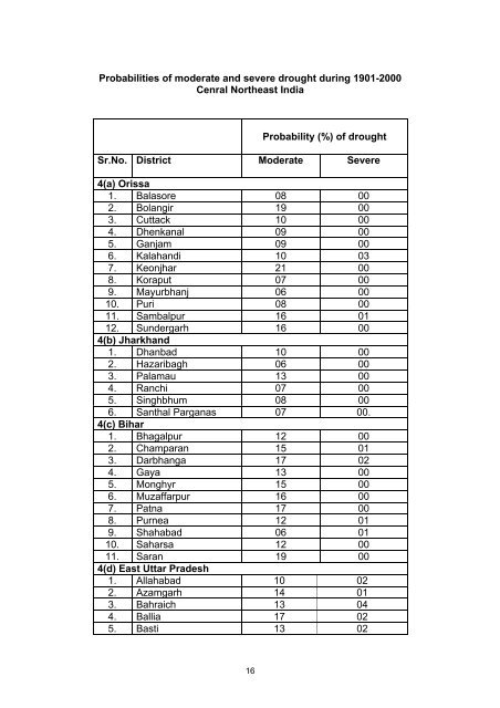
Probabilities <strong>of</strong> moderate and severe drought during 1901-2000Cenral Northeast <strong>India</strong>Probability (%) <strong>of</strong> droughtSr.No. District Moderate Severe4(a) Orissa1. Balasore 08 002. Bolangir 19 003. Cuttack 10 004. Dhenkanal 09 005. Ganjam 09 006. Kalahandi 10 037. Keonjhar 21 008. Koraput 07 009. Mayurbhanj 06 0010. Puri 08 0011. Sambalpur 16 0112. Sundergarh 16 004(b) Jharkhand1. Dhanbad 10 002. Hazaribagh 06 003. Palamau 13 004. Ranchi 07 005. Singhbhum 08 006. Santhal Parganas 07 00.4(c) Bihar1. Bhagalpur 12 002. Champaran 15 013. Darbhanga 17 024. Gaya 13 005. Monghyr 15 006. Muzaffarpur 16 007. Patna 17 008. Purnea 12 019. Shahabad 06 0110. Saharsa 12 0011. Saran 19 004(d) East Uttar Pradesh1. Allahabad 10 022. Azamgarh 14 013. Bahraich 13 044. Ballia 17 025. Basti 13 0216


