

Mapping of Drought Areas over India - (IMD), Pune
Mapping of Drought Areas over India - (IMD), Pune
Mapping of Drought Areas over India - (IMD), Pune

Create successful ePaper yourself
Turn your PDF publications into a flip-book with our unique Google optimized e-Paper software.
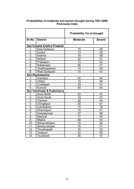
Probabilities <strong>of</strong> moderate and severe drought during 1901-2000Peninsular <strong>India</strong>Probability (%) <strong>of</strong> droughtSr.No. District Moderate Severe3(a) Coastal Andhra Pradesh1. East Godavari 15 002. Guntur 13 003. Krishna 18 004. Nellore 22 015. Prakasam 13 036. Srikakulam 06 017. Visakhapatnam 14 008. West Godavari 15 013(b) Rayalaseema1. Anantpur 20 042. Chittor 15 003. Cuddapah 24 014. Kurnool 09 043(c) Tamilnadu & Puducherry1. Arcot North 23 012. Arcot South 19 013. Chennai 20 044. Chingleput 20 015. Coimbatore 15 186. Dharmapuri 19 017. Kanyakumari 27 068. Madurai 17 049. Nilgiris 08 0310. Ramanathapur 18 0911. Sambuvarayar 16 0112. Tiruchirapalli 16 0313. Tanjavur 22 0514. Tirunelveli 25 0714


