

Mapping of Drought Areas over India - (IMD), Pune
Mapping of Drought Areas over India - (IMD), Pune
Mapping of Drought Areas over India - (IMD), Pune

You also want an ePaper? Increase the reach of your titles
YUMPU automatically turns print PDFs into web optimized ePapers that Google loves.
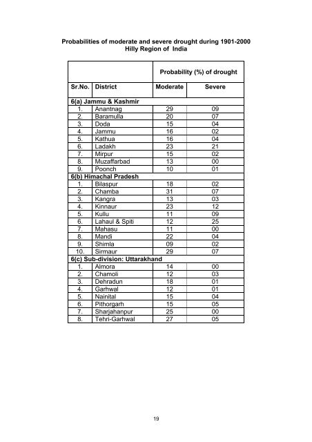
Probabilities <strong>of</strong> moderate and severe drought during 1901-2000Hilly Region <strong>of</strong> <strong>India</strong>Probability (%) <strong>of</strong> droughtSr.No. District Moderate Severe6(a) Jammu & Kashmir1. Anantnag 29 092. Baramulla 20 073. Doda 15 044. Jammu 16 025. Kathua 16 046. Ladakh 23 217. Mirpur 15 028. Muzaffarbad 13 009. Poonch 10 016(b) Himachal Pradesh1. Bilaspur 18 022. Chamba 31 073. Kangra 13 034. Kinnaur 23 125. Kullu 11 096. Lahaul & Spiti 12 257. Mahasu 11 008. Mandi 22 049. Shimla 09 0210. Sirmaur 29 076(c) Sub-division: Uttarakhand1. Almora 14 002. Chamoli 12 033. Dehradun 18 014. Garhwal 12 015. Nainital 15 046. Pithorgarh 15 057. Sharjahanpur 25 008. Tehri-Garhwal 27 0519


