

Mapping of Drought Areas over India - (IMD), Pune
Mapping of Drought Areas over India - (IMD), Pune
Mapping of Drought Areas over India - (IMD), Pune

You also want an ePaper? Increase the reach of your titles
YUMPU automatically turns print PDFs into web optimized ePapers that Google loves.
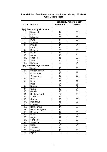
Probabilities <strong>of</strong> moderate and severe drought during 1901-2000West Central <strong>India</strong>Probability (%) <strong>of</strong> droughtSr.No. District Moderate Severe2(a) East Madhya Pradesh1. Balaghat 14 002. Bastar 14 003. Bilaspur 06 004. Durg 11 005. Jabalpur 14 006. Mandla 11 017. Panna 16 048. Raigarh 06 009. Rewa 17 0210. Satna 15 0111. Shahdol 15 0012. Sidhi 22 0313. Surguja 09 012(b) West Madhya Pradesh1. Bhind 16 082. Bhilsa/Vidisha 19 003. Chhatrapur 16 054. Chindwara 18 005. Damoh 15 016. Dhar 23 027. Datia 24 038. Dewas 25 029. Guna 17 0110. Gwalior 13 0611. Hoshangabad 22 0012. Indore 19 0213. Jhabua 20 0314. Mandsaur 15 0315. Morena 18 0516. Narsinghpur 14 0017. Nimar/Khargone 15 0018. Raesen 12 0119. Ratlam 24 0320. Sagar 12 0021. Sehpore 22 0222. Shajapur 20 0223. Seoni 21 0124. Shivpuri 17 0225. Tikamgarh 19 0326. Ujjain 23 0311


