

Mapping of Drought Areas over India - (IMD), Pune
Mapping of Drought Areas over India - (IMD), Pune
Mapping of Drought Areas over India - (IMD), Pune

Create successful ePaper yourself
Turn your PDF publications into a flip-book with our unique Google optimized e-Paper software.
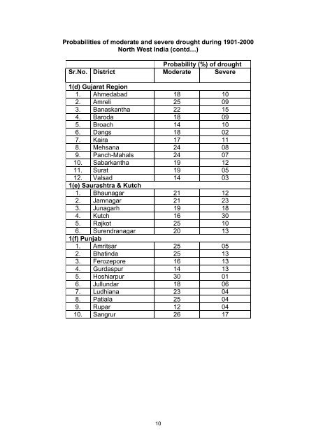
Probabilities <strong>of</strong> moderate and severe drought during 1901-2000North West <strong>India</strong> (contd…)Probability (%) <strong>of</strong> droughtSr.No. District Moderate Severe1(d) Gujarat Region1. Ahmedabad 18 102. Amreli 25 093. Banaskantha 22 154. Baroda 18 095. Broach 14 106. Dangs 18 027. Kaira 17 118. Mehsana 24 089. Panch-Mahals 24 0710. Sabarkantha 19 1211. Surat 19 0512. Valsad 14 031(e) Saurashtra & Kutch1. Bhaunagar 21 122. Jamnagar 21 233. Junagarh 19 184. Kutch 16 305. Rajkot 25 106. Surendranagar 20 131(f) Punjab1. Amritsar 25 052. Bhatinda 25 133. Ferozepore 16 134. Gurdaspur 14 135. Hoshiarpur 30 016. Jullundar 18 067. Ludhiana 23 048. Patiala 25 049. Rupar 12 0410. Sangrur 26 1710


