

Mapping of Drought Areas over India - (IMD), Pune
Mapping of Drought Areas over India - (IMD), Pune
Mapping of Drought Areas over India - (IMD), Pune

You also want an ePaper? Increase the reach of your titles
YUMPU automatically turns print PDFs into web optimized ePapers that Google loves.
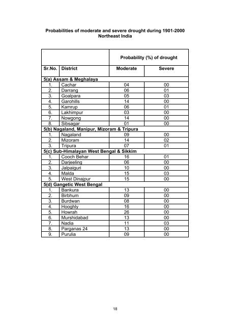
Probabilities <strong>of</strong> moderate and severe drought during 1901-2000Northeast <strong>India</strong>Probability (%) <strong>of</strong> droughtSr.No. District Moderate Severe5(a) Assam & Meghalaya1. Cachar 04 002. Darrang 06 013. Goalpara 05 034. Garohills 14 005. Kamrup 06 016. Lakhimpur 03 007. Nowgong 14 008. Sibsagar 01 005(b) Nagaland, Manipur, Mizoram & Tripura1. Nagaland 09 002. Mizoram 14 023. Tripura 07 015(c) Sub-Himalayan West Bengal & Sikkim1. Cooch Behar 16 012. Darjeeling 06 003. Jalpaiguri 10 004. Malda 15 035. West Dinajpur 15 005(d) Gangetic West Bengal1. Bankura 13 002. Birbhum 09 003. Burdwan 08 004. Hooghly 16 005. Howrah 26 006. Murshidabad 13 007. Nadia 11 038. Parganas 24 13 009. Purulia 09 0018


