DESTRUCTION OF GEODETIC CONTROL STATIONSWhen conditions indicate that a Federal or State geodetic controlstation nmst be moved, lowered or raised to accommodate constructionactivities, contact the Topographic Engineer (telephone number: AreaCode 609, 292-2576) as far ill advance as possible. Arrangements willbe made to protect tile position so that work schedules may proceedefficiently. In cases which preclude this course of action, control stationsmay be altered in position only under the supervision of a licensedProfessional Engineer or Land Surveyor uslng standard methods. Copiesof field notes and instrument, tape, and rod specifications (includingcalibration data) should be submitted so that computation files may bekept current.EXPLANATION OF NEW JERSEY GEODETICCONTROL SURVEY STATION DESIGNATIONSThe following definitions apply generally to traverse stations andbench marks established or used ,by the <strong>New</strong> <strong>Jersey</strong> Geodetic ControlSurvey. Exceptions occur in cases where strict adherence to rules wasnot considered expedient due to ground conditions, instrument setup orother adverse factors.MONUMENT - (MON.), DISK - (DK.) : A standard United StatesCoast and Geodetic Survey and State Survey ° or <strong>New</strong> <strong>Jersey</strong> GeodeticControl Survey disk set in a concrete post, pavement, curb, ledge rock,etc., stamped with a reference number, and used <strong>for</strong> both horizontal andvertical controlPOINT - (PT.): State Highway, Riparian, city, etc. survey markerrepresented by a chiseled cross, punch hole, brass plug, etc., used <strong>for</strong>horizontal and vertical control. These stations are not marked, but ifthere should be an enclosing box, .the rim is stamped with a number.RIFET - (RV.) : A standard monel metal rivet set by the <strong>New</strong> <strong>Jersey</strong>Geodetic Control Survey, used <strong>for</strong> vertical control.MARK - (MK.) : Same as POINT, hut used only <strong>for</strong> vertical control.In the description of such marks there should appear our mark numberfollowed ,by an equality sign and then the original name or elevation ofthe bench mark, together with the name of the organization which esta'blishedit in parentheses.SBe<strong>for</strong>e complete responsibility <strong>for</strong> the maintenance of <strong>New</strong> ,lersey GeodeticControl Survey stations was delegated to a State agency, disks were inscribed"United States Coast and Geodetic Survey and State Survey". This inscription wasused to indtcate partinlpation of the United States Coast and Cceodetin Survey ina cooperative program with the State of <strong>New</strong> <strong>Jersey</strong>. At present, all control stationsmarked in this manner are part of the <strong>New</strong> <strong>Jersey</strong> Geodetic Control SurveySystem.33NEW JERSEY GEOLOGICAL SURVEY
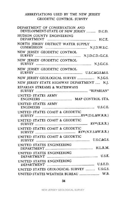
ABBREVIATIONS USED BY THE NEW JERSEYGEODETIC CONTROL SURVEYDEPARTMENT OF CONSERVATION ANDDEVELOPMENT-STATE OF NEW JERSEY ............ D.C.D.HUDSON COUNTY ENGINEERINGDEPARTMENT ................................................................ H.C.E.NORTH JERSEY DISTRICT WATER SUPPLYCOMMISSION ...................................................... N.J.D.W.S.C.NEW JERSEY GEODETIC CONTROLSURVEY ............................................................ N.J.D.C.D.-G.C.S.NEW JERSEY GEODETIC CONTROLSURVEY ........................................................................ N.J.G.C.S.NEW JERSEY GEODETIC CONTROLSURVEY .............................................................. U.S.C.&G.S.&S.S.NEW JERSEY GEOLOGICAL SURVEY ...................... N.J.G.S.NEW JERSEY STATE HIGHWAY DEPARTMENT ...... N.J.RIPARIAN STREAMS & WATERWAYSSURVEY .................................................................... "RIPARIAN"UNITED STATES ARMYENGINEERS ........................................ MAP CONTROL STA.UNITED STATES ARMYENGINEERS .................................................................... U.S.C.E.UNITED STATES COAST & GEODETICSURVEY ............................................................ RV# (D.L.&W.R.R.)UNITED STATES COAST & GEODETICSURVEY .................................................................... RV#(E.R.R.)UNITED STATES COAST & GEODETICSURVEY .................................................... RV# (N.Y.S.&W.R.R.)UNITED STATES COAST & GEODETICSURVEY ...................................................................... U.S.C.&G.S.UNITED STATES ENGINEERINGDEPARTMENT .............................................................. H.L.R.M.UNITED STATES ENGINEERINGDEPARTMENT .................................................................. U.S.E.UNITED STATES ENGINEERINGDEPARTMENT .............................................................. U.S.E.D.UNITED STATES GEOLOGICAl, SURVEY ............ U.S.G.S.UNITED STATES WEATHER BUREAU .......................... W.B.34NEW JERSEY GEOLOGICAL SURVEY
- Page 1 and 2: MAPPING DIGESTFORNEW JERSEYBULLETIN
- Page 3 and 4: BULLETIN 66MAPPINGDIGESTFORNEWJERSE
- Page 5 and 6: CONTENTSIntroduction ..............
- Page 7 and 8: SECTIONINEW JERSEY GEOLOGICAL SURVE
- Page 9 and 10: the inactive New Jersey Geological
- Page 11 and 12: scale for 7_-minute maps; the Geolo
- Page 13 and 14: of a Lambert Projection, Dr. Adams
- Page 15 and 16: 4. U.S. Department of Commerce, For
- Page 17 and 18: SURVEYING -- THE PAST AND THE FUTUR
- Page 19 and 20: MAGNETICDATA"The original magnetic
- Page 21 and 22: REFERENCESCITEDl. U. S. Department
- Page 23 and 24: SELECTEDREFERENCES1. McDonald, Fred
- Page 25 and 26: REFERENCESCITED1. U. S. Department
- Page 27 and 28: level. However, the elevation of th
- Page 29 and 30: carefully analyze needs with respec
- Page 31 and 32: BIBLIOGRAPHY OF SELECTED REFERENCES
- Page 34 and 35: ,jc,reO(._C..._0e__,_mt_©30Z_i_:"
- Page 36 and 37: II0 I_1_ lt3"_L I I_1"I1_ li_l_i_ _
- Page 38 and 39: NEW JERSEY GEODETIC CONTROL SURVEYM
- Page 42 and 43: U.S. DEPARTMENT OF COMMERCECOAST AN
- Page 44 and 45: In areas where quadrangles have not
- Page 46 and 47: 2. A recent communication (December
- Page 48 and 49: PageSLD-MLWNumber Locality Feet11 D
- Page 50 and 51: PageSLD-MLWNumber Locality Feet82 G
- Page 52 and 53: CHARTSCALES & EQUIVALENTS*FRACTIONA
- Page 54 and 55: Most of the agents carry only those
- Page 56 and 57: IIdesignations of Atlas Sheets and
- Page 58 and 59: Large Scale MapsBull Report} Bull.
- Page 60 and 61: .All of the selected maps listed be
- Page 62 and 63: Somerset (1960) -- 4 sheetsPrice ea
- Page 64 and 65: For these 27 maps, the contouring w
- Page 66 and 67: Film positive, up to 42"x70", price
- Page 68 and 69: The following publication lists mos
- Page 70 and 71: NOTESNEW JERSEY GEOLOGICAL SURVEY
- Page 72 and 73: NEW JERSEY GEOLOGICAL SURVEY