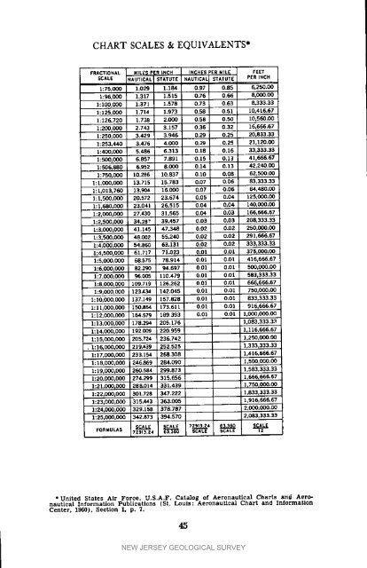
CHARTSCALES & EQUIVALENTS*FRACTIONAL MILES PERiNCH INCHESPERMllrE, FEETSCALE NAUTICAL STATUTE NAUTICAL STATUTE PER]_JCH1:75.000 1.029 1.18,4 0.97 0.85 6.250.CO1:96,000 1.317 1.515 0,76 0.<strong>66</strong> 8,000.001:100.000 1.371 1.578 0.73 0.63 8.333.331:125,0Q0 1.714 1.973 0.50 0.51 10,416.671:126,720 1.738 2.000 0.53 0.50 10.560.001:200,0C0 2.743 3.157 0.35 0.32 10,<strong>66</strong>6.671:250,000 3.429 3.946 0,29 0.25 20,833.331:253,440 3.476 4.0QO 0.29 0.25 21,120.001:400.000 5.486 6.313 0.18 0.16 33,333.331:500,000 6.857 7.891 0.15 0.23 4].655.671:506,880 6.952 8.(X_ 0.14 0.13 42,240.001_750.0Q0 10.286 10.337 0,10 0.03 62,500.001:1,000,000 13.715 15.783 0.07 0.06 83,333.331:1,013,700 13.904 16.000 0.07 0.06 84,480.00l: 1,500,C
LIST OF NEW JERSEY MAPSThe following section is devoted to a listing of <strong>New</strong> <strong>Jersey</strong> maps andcharts which are produced by various State and Federal agencies. Theaddresses of sales agents are shown immediately preceding each listing.It will be noted that the <strong>New</strong> <strong>Jersey</strong> Bureau of Geology and Topography,as a convenience to tile public, stocks and sells several types ofmaps produced by the Federal Government. In all cases caution shouldhe exercised in addressing orders so that the proper sales agency is contacted.Dates where shown indicate the period during which each mapseries was compiled or published.Bureau of Geology and TopegrophyP.O. Box 1889Trenton, <strong>New</strong> <strong>Jersey</strong> 08625In this section, maps which are not credited to a specific agency arecompiled and published by the Bureau of Geology and Topography.TOPOGRAPHIC MANUSCRIPT _IAPS, 1877-1887. Scale 3inches per mile (1:21,120), sizes vary considerably. Black and whiteprints, contour intervals vary from 5 feet to 20 feet depending uponthe relief of an area, 101 sheets. These maps show state, county andmunicipal boundaries, drainage, place names, railroads, roads andwooded areas as of the date of the survey. Although the culture isantiquated, the large scale and hypsography often allow a brief andinexpensive solution to a topographic mapping problem. In addition, thisseries of maps contains in<strong>for</strong>mation of historical interest.Copies of these original tracings of the Topographic Survey of <strong>New</strong><strong>Jersey</strong> are produced upon request. Orders should specify the area ofinterest.Minimum charge per map .................... $2.00Additional charge per square foot <strong>for</strong>maps over six square feet in area ........ $0.2571_- MINUTE TOPOGRAPHIC QUADRANGLES, 1942-1958Published by the United States Geological Survey, scale 2.64 inches permile (1:24,000), 22"x27" (sizes vary slightly). Five colors, contourintervals vary from I0 feet to 20 feet depending upon the relief of anarea, 172 sheets to cover <strong>New</strong> <strong>Jersey</strong>. These maps show state, countyand municipal boundaries, buildings in rural areas, drainage, place names,railroads, roads, and wooded areas.Price each .............................................. $0.50A 22"x27" index to this map series is furnished free upon request.This index also provides in<strong>for</strong>mation concerning the location of salesagents in <strong>New</strong> York City, Philadelphia, and throughout <strong>New</strong> <strong>Jersey</strong>.49NEW JERSEY GEOLOGICAL SURVEY
- Page 1 and 2: MAPPING DIGESTFORNEW JERSEYBULLETIN
- Page 3 and 4: BULLETIN 66MAPPINGDIGESTFORNEWJERSE
- Page 5 and 6: CONTENTSIntroduction ..............
- Page 7 and 8: SECTIONINEW JERSEY GEOLOGICAL SURVE
- Page 9 and 10: the inactive New Jersey Geological
- Page 11 and 12: scale for 7_-minute maps; the Geolo
- Page 13 and 14: of a Lambert Projection, Dr. Adams
- Page 15 and 16: 4. U.S. Department of Commerce, For
- Page 17 and 18: SURVEYING -- THE PAST AND THE FUTUR
- Page 19 and 20: MAGNETICDATA"The original magnetic
- Page 21 and 22: REFERENCESCITEDl. U. S. Department
- Page 23 and 24: SELECTEDREFERENCES1. McDonald, Fred
- Page 25 and 26: REFERENCESCITED1. U. S. Department
- Page 27 and 28: level. However, the elevation of th
- Page 29 and 30: carefully analyze needs with respec
- Page 31 and 32: BIBLIOGRAPHY OF SELECTED REFERENCES
- Page 34 and 35: ,jc,reO(._C..._0e__,_mt_©30Z_i_:"
- Page 36 and 37: II0 I_1_ lt3"_L I I_1"I1_ li_l_i_ _
- Page 38 and 39: NEW JERSEY GEODETIC CONTROL SURVEYM
- Page 40 and 41: DESTRUCTION OF GEODETIC CONTROL STA
- Page 42 and 43: U.S. DEPARTMENT OF COMMERCECOAST AN
- Page 44 and 45: In areas where quadrangles have not
- Page 46 and 47: 2. A recent communication (December
- Page 48 and 49: PageSLD-MLWNumber Locality Feet11 D
- Page 50 and 51: PageSLD-MLWNumber Locality Feet82 G
- Page 54 and 55: Most of the agents carry only those
- Page 56 and 57: IIdesignations of Atlas Sheets and
- Page 58 and 59: Large Scale MapsBull Report} Bull.
- Page 60 and 61: .All of the selected maps listed be
- Page 62 and 63: Somerset (1960) -- 4 sheetsPrice ea
- Page 64 and 65: For these 27 maps, the contouring w
- Page 66 and 67: Film positive, up to 42"x70", price
- Page 68 and 69: The following publication lists mos
- Page 70 and 71: NOTESNEW JERSEY GEOLOGICAL SURVEY
- Page 72 and 73: NEW JERSEY GEOLOGICAL SURVEY