

NJDEP - NJGS - Bulletin 66, Mapping Digest for New Jersey, 1965
NJDEP - NJGS - Bulletin 66, Mapping Digest for New Jersey, 1965
NJDEP - NJGS - Bulletin 66, Mapping Digest for New Jersey, 1965

You also want an ePaper? Increase the reach of your titles
YUMPU automatically turns print PDFs into web optimized ePapers that Google loves.
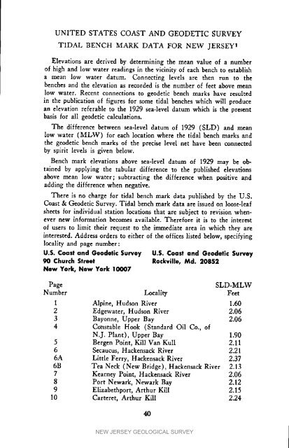
UNITED STATES COAST AND GEODETIC SURVEYTIDAL BENCH MARK DATA FOR NEW JERSEY tElevations are derived by determining the mean value of a numberof high and low water readings in the vicinity of each bench to establisha mean low water datum. Connecting levels are then run to thebenches and the elevation as recorded is the number of feet above meanlow water. Recent connections to geodetic bench marks have resultedin the publication of figures <strong>for</strong> some tidal benches which will producean elevation referable to the 1929 sea-level datum which is the presentbasis <strong>for</strong> all geodetic calculations.The difference between sea-level datum of 1929 (SLD) and meanlow water (MLW) <strong>for</strong> each location where the tidal bench marks andthe geodetic bench marks of the precise level net have been connectedby spirit levels is given below.Bench mark elevations above sea-level datum of 1929 may be obtainedby applying the tabular difference to the published elevationsabove mean low water; subtracting the difference when positive andadding the difference when negative.There is no charge <strong>for</strong> tidal bench mark data published by the U.S.Coast & Geodetic Survey. Tidal bench mark data are issued on loose-leafsheets <strong>for</strong> individual station locations that are subject to revision whenevernew in<strong>for</strong>mation becomes available. There<strong>for</strong>e it is to the interestof users to limit their request to the immediate area in which they areinterested. Address orders to either of the offices listed below, specifyinglocality and page number:U.S. Coast and Geodetic Survey U.S. Coast and Geodetic Survey90 Church Street Rockville, Md. 20852<strong>New</strong> York, <strong>New</strong> York 10007PageSLD-MLWNumber Locality FeetI Alpine, Hudson River 1.602 Edgewater, Hudson River 2.063 Bayonne, Upper Bay 2.064 Constable Hook (Standard Oil Co., ofN.J. Plant), Upper Bay 1.905 Bergen Point, Kill Van KuI1 2.116 Secaucus, Hackensack River 2.216A Little Ferry, Hackensack River 2.376B Tea Neck (<strong>New</strong> Bridge), Hackensack River 2.137 Kearney Point, Hackensack River 2.068 Port <strong>New</strong>ark, <strong>New</strong>ark Bay 2.129 Elizabethport, Arthur Kill 2.1510 Carteret, Arthur Kill 2.2440NEW JERSEY GEOLOGICAL SURVEY


