

NJDEP - NJGS - Bulletin 66, Mapping Digest for New Jersey, 1965
NJDEP - NJGS - Bulletin 66, Mapping Digest for New Jersey, 1965
NJDEP - NJGS - Bulletin 66, Mapping Digest for New Jersey, 1965

Create successful ePaper yourself
Turn your PDF publications into a flip-book with our unique Google optimized e-Paper software.
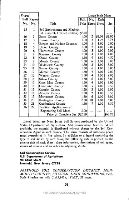
Large Scale MapsBull Report} Bull. No. EachINo. No. Title Price Sheets Sheet Set15 1 Soil Environment and Methodsof Research (revised edition) $2.013 ..................16 2 Essex County 1.00 2 _1.00 $2.0017 3 Passaic County 1.00 3 1.25 3.7518 4 Bergen and Hudson Counties 1.00 5 1.00 5.0019 5 Union County 1.00 2 1.00 2.0020 6 Hunterdon County 1.00 5 1.00 5.0021 7 Somerset County 1.00 4 1.00 4.0022 8 Ocean County 1.50 9 1.00 4.5023 9 Morris County 1.50 6 1.00 3.0024 10 Middlesex County 1.50 3 1.00 3.00*25 11 Sussex County 1.50 6 1.00 3.0026 12 Mercer County 1.50 4 1.00 2.0027 13 Warren County 1.50 4 1.00 2.0028 14 Salem County 1.50 6 1.00 3.0029 15 Cape May County 1.50 4 1.00 2.0030 16 Gloucester County 1.50 5 1.00 2.5031 17 Camden County 1.50 3 1.00 2.0032 18 Atlantic County 1.50 7 1.00 3.5033 19 Monmouth County 1.50 6 1.00 3.0034 20 Burlington County 2.00 10 1.00 5.0035 21 Cumberland County 1.50 7 1.00 3.5036 22 Practical Applications ofEngineering Soil Maps 3.00 .................Price of Complete Set $32.50 i.$63.76Listed below are <strong>New</strong> <strong>Jersey</strong> Soil Surveys produced by the UnitedStates Department of Agriculture, Soil Conservation Service. Whenavailable, the material is distributed without charge 'by the Soil ConservationAgent in each county. This series consists of half-tone photomaps overprinted in five colors. In addition to a legend specifying thetype of soil shown by each color, the following data is printed on thereverse side of each sheet: slope in<strong>for</strong>mation, descriptions of soil types,classes of erosion and an index to adjoining sheets.Soil Conservation ServiceU.S. Department of Agriculture28 Court StreetFreehold, <strong>New</strong> <strong>Jersey</strong> 07728FREEHOLD SOIL CONSERFATION DISTRICT, MON-MOUTH COUNTY, PHYSICAL LAND CONDITIONS, 1948.Scale 4 inches per mile (I :15,840), 18"x22", 33 maps.54NEW JERSEY GEOLOGICAL SURVEY


