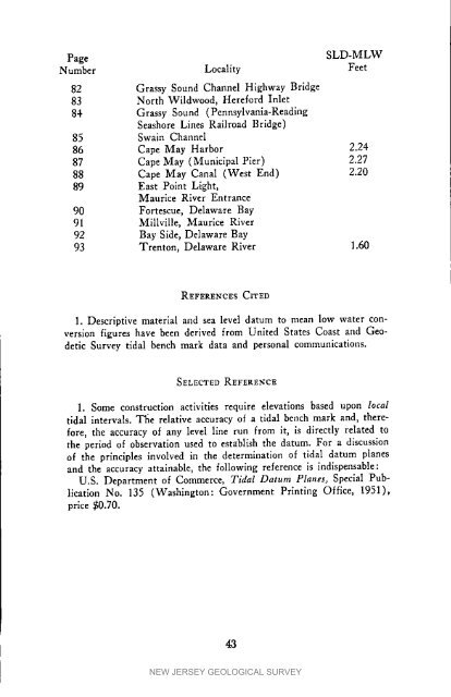
PageSLD-MLWNumber Locality Feet82 Grassy Sound Channel Highway Bridge83 North Wildwood, Here<strong>for</strong>d Inlet84 Grassy Sound (Pennsylvania-ReadlngSeashore Lines Railroad Bridge)85 Swain Channel86 Cape May Harbor 2.2487 Cape May (Municipal Pier) 2.2788 Cape May Canal (West End) 2.2089 East Point Light,Maurice River Entrance90 Fortescue, Delaware Bay91 Millville, Maurice River92 Bay Side, Delaware Bay93 Trenton, Delaware River 1.60REFERENCESCITEDI. Descriptive material and sea level datum to mean low water conversionfigures have been derived from United States Coast and GeodeticSurvey tidal bench mark data and personal communications.SELECTEDREFERENCE1. Some construction activities require elevations based upon localtidal intervals. The relative accuracy of a tidal bench mark and, there<strong>for</strong>e,the accuracy of any level llne run from it, is directly related tothe period of observation used to establish the datum. For a discussionof the principles involved in the determination of tidal datum planesand the accuracy attainable, the following reference is indispensable:U.S. Department of Commerce, Tidal Datum Planes, Special PublicationNo. 135 (Washington: Government Printing Office, 1951),price $0.70.43NEW JERSEY GEOLOGICAL SURVEY
CHARTSCALES & EQUIVALENTS*FRACTIONAL MILESPERiNCH INCHESPERMILE FEETSCALE NAUTICAL STATUTE NAUTICAL STATUTE pER INCH1:500 0,007 0.008 145,83 126.72 41.671:600 0,008 0,009 121.52 105.60 50.001:1,000 0.014 0.016 72.91 53.36 83,331:1,200 0.016 0.019 60,76 52.80 100,001:I,500 0,021 0.024 48.61 42.24 125,001:2,000 0.027 0.032 36.46 31.68 1<strong>66</strong>.671:2.400 03333 0.038 30.38 26.40 200.001:2,500 0,034 0,039 29.17 25.34 208,331:3,000 0,041 0.047 24,30 21,12 250.001:3,600 0.049 0.057 20.25 17.60 300.001:4,000 0.055 0.063 18.23 15,84 333.331:4,800 0.0<strong>66</strong> 0.076 15.19 13.20 400.001:5,000 0.069 0.079 14.58 12.67 416.671:6,000 0.082 0.095 12.15 10,56 500.001:7,000 0.096 0.110 10.42 9.05 683.331:7,200 0.099 0.114 10.13 8.80 600.001:7,920 0.109 0.126 9.21 8.00 <strong>66</strong>0.001;8,000 0.110 0.126 9.11 7.92 <strong>66</strong>6.671:8,400 0.115 0,133 8.68 7,54 700.001:9,000 0,123 0.]42 8.10 "7.04 750.001:9,600 0,132 0.152 7.60 6.60 800.001:10,000 0.137 0.158 7.29 6.34 833.331:10r800 0,148 0,170 6,75 5.87 900,001:12,000 0,165 0.189 6.08 5.28 1,000.C01:13,200 0.181 01208 5.52 4.80 1,100.001:14,400 0,197 0.227 5.06 4,40 lr200.001:15,000 0.206 0,237 4.86 4.22 1,250.001:15,600 0.214 0.246 4.67 4.06 1,300.001:15,840 0,217 0.250 4.60 4.00 1,320.001:16,0C0 0.219 0.253 4.56 3,96 1,333.33I:16,800 0.230 0.265 4.34 3.77 1,400.001:18,000 0.247 0.284 4*05 3.52 L500.O01:19,200 0.263 0.303 3.80 3,30 1,600.001:20,000 0.274 0.316 3.65 3.17 1_<strong>66</strong>6.671:20,400 ! 0,280 0.322 3.57 3.11 1,700.001:21,120 0,290 0.333 3.45 3.00 1,760,001:21,600 0.296 0.341 3.38 2.93 1,800.001:22,800 0,313 0.360 3.20 2,78 11900.001:24.000 0.329 0.379 3.04 2.64 2_000,001:25,000 0,343 0,395 2.92 2.53 2,083.331:31,680 0,434 0,500 2,30 2.00 2,640,001:48,C00 0.658 0.758 1.52 1.32 4,000,001:50,000 0.686 0.789 1.46 ].27 4,1<strong>66</strong>.671:62,500 0.857 0,986 1.17 l.O1 5,208.331:63_360 i 0.869 1,000 1.15 1,00 5,280,00• United States Air Force, U.S.A.F. Cata]og cf Aeronautical Charts and AeronauticalIn<strong>for</strong>mation Publications (St. Louis: Aeronautical Chart and In<strong>for</strong>mationCenter, 1960), Section I. p. 7.44NEW JERSEY GEOLOGICAL SURVEY
- Page 1 and 2: MAPPING DIGESTFORNEW JERSEYBULLETIN
- Page 3 and 4: BULLETIN 66MAPPINGDIGESTFORNEWJERSE
- Page 5 and 6: CONTENTSIntroduction ..............
- Page 7 and 8: SECTIONINEW JERSEY GEOLOGICAL SURVE
- Page 9 and 10: the inactive New Jersey Geological
- Page 11 and 12: scale for 7_-minute maps; the Geolo
- Page 13 and 14: of a Lambert Projection, Dr. Adams
- Page 15 and 16: 4. U.S. Department of Commerce, For
- Page 17 and 18: SURVEYING -- THE PAST AND THE FUTUR
- Page 19 and 20: MAGNETICDATA"The original magnetic
- Page 21 and 22: REFERENCESCITEDl. U. S. Department
- Page 23 and 24: SELECTEDREFERENCES1. McDonald, Fred
- Page 25 and 26: REFERENCESCITED1. U. S. Department
- Page 27 and 28: level. However, the elevation of th
- Page 29 and 30: carefully analyze needs with respec
- Page 31 and 32: BIBLIOGRAPHY OF SELECTED REFERENCES
- Page 34 and 35: ,jc,reO(._C..._0e__,_mt_©30Z_i_:"
- Page 36 and 37: II0 I_1_ lt3"_L I I_1"I1_ li_l_i_ _
- Page 38 and 39: NEW JERSEY GEODETIC CONTROL SURVEYM
- Page 40 and 41: DESTRUCTION OF GEODETIC CONTROL STA
- Page 42 and 43: U.S. DEPARTMENT OF COMMERCECOAST AN
- Page 44 and 45: In areas where quadrangles have not
- Page 46 and 47: 2. A recent communication (December
- Page 48 and 49: PageSLD-MLWNumber Locality Feet11 D
- Page 52 and 53: CHARTSCALES & EQUIVALENTS*FRACTIONA
- Page 54 and 55: Most of the agents carry only those
- Page 56 and 57: IIdesignations of Atlas Sheets and
- Page 58 and 59: Large Scale MapsBull Report} Bull.
- Page 60 and 61: .All of the selected maps listed be
- Page 62 and 63: Somerset (1960) -- 4 sheetsPrice ea
- Page 64 and 65: For these 27 maps, the contouring w
- Page 66 and 67: Film positive, up to 42"x70", price
- Page 68 and 69: The following publication lists mos
- Page 70 and 71: NOTESNEW JERSEY GEOLOGICAL SURVEY
- Page 72 and 73: NEW JERSEY GEOLOGICAL SURVEY