

NJDEP - NJGS - Bulletin 66, Mapping Digest for New Jersey, 1965
NJDEP - NJGS - Bulletin 66, Mapping Digest for New Jersey, 1965
NJDEP - NJGS - Bulletin 66, Mapping Digest for New Jersey, 1965

You also want an ePaper? Increase the reach of your titles
YUMPU automatically turns print PDFs into web optimized ePapers that Google loves.
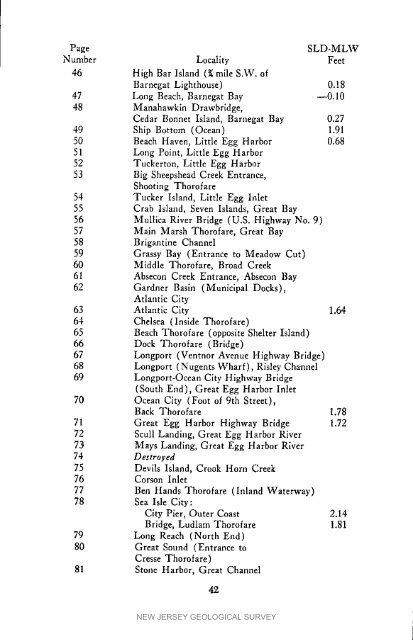
PageSLD-MLWNumber Locality Feet46 High Bar Island (t; mile S.W. ofBarnegat Lighthouse) 0.1847 Long Beach, Barnegat Bay --0.1048 Manahawkin Drawbridge,Cedar Bonnet Island, Barnegat Bay 0.2749 Ship Bottom (Ocean) 1.9150 Beach Haven, Little Egg Harbor 0.6851 Long Point, Little Egg Harbor52 Tuckerton, Little Egg Harbor53 Big Sheepshead Creek Entrance,Shooting Thorofare54 Tucker Island, Little Egg Inlet55 Crab Island, Seven Islands, Great Bay56 Mullica River Bridge (U.S. Highway No. 9)57 Mzin Marsh Thorofare, Great Bay58 Brigantine Channel59 Grassy Bay (Entrance to Meadow Cut)60 Middle Thorofare, Broad Creek61 Absecon Creek Entrance, Absecon Bay62 Gardner Basin (Municipal Docks),Atlantic City63 Atlantic City 1.6464 Chelsea (Inside Thorofare)65 Beach Thorofare (opposite Shelter Island)<strong>66</strong> Dock Thorofare (Bridge)67 Longport (Ventnor Avenue Highway Bridge)68 Longport (N ugents Wharf ), Risley Channel69 Longport-Ocean City Highway Bridge(South End), Great Egg Harbor Inlet70 Ocean City (Foot of 9th Street),Back Thorofare 1.7871 Great Egg Harbor Highway Bridge 1.7272 Scull Landing, Great Egg Harbor River73 Mays Landing, Great Egg Harbor River74 Destroyed75 Devils Island, Crook Horn Creek76 Corson Inlet77 Ben Hands Thorofare (Inland Waterway)78 Sea Isle City:City Pier, Outer Coast 2.14Bridge, Ludlam Thorofare 1.8179 Long Reach (North End)80 Great Sound (Entrance toCresse Thorofare)81 Stone Harbor, Great Channel42NEW JERSEY GEOLOGICAL SURVEY


