

NJDEP - NJGS - Bulletin 66, Mapping Digest for New Jersey, 1965
NJDEP - NJGS - Bulletin 66, Mapping Digest for New Jersey, 1965
NJDEP - NJGS - Bulletin 66, Mapping Digest for New Jersey, 1965

Create successful ePaper yourself
Turn your PDF publications into a flip-book with our unique Google optimized e-Paper software.
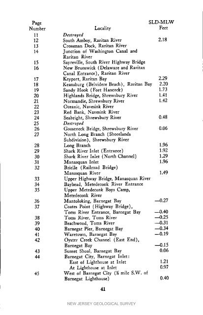
PageSLD-MLWNumber Locality Feet11 Destroyed12 South Amboy, Raritan River 2.1813 Crossman Dock, Raritan River14 Junction of Washington Canal andRarltan River15 Sayreville, South River Highway Bridge16 <strong>New</strong> Brunswick (Delaware and RaritanCanal Entrance), Raritan River17 Keyport, Raritan Bay 2.2918 Keansburg (Belvidere Beach), Raritan Bay 2.2019 Sandy Hook (Fort Hancock) 1.7320 Highlands Bridge, Shrewsbury River 1.4121 Normandie, Shrewsbury River 1.4222 Oceanic, Navesink River23 Red Bank, Navesink River24 Seabrlght, Shrewsbury River 0.4825 Destroyed26 Gooseneck Bridge, Shrewsbury River 0.0627 North Long Branch (ShorelandsSubdivision), Shrewsbury River28 Long Branch 1.9629 Shark River Inlet (Entrance) 1.9230 Shark River Inlet (North Channel) 1.2931 Manasquan Inlet 1.9632 Brielle (Railroad Bridge)Manasquan River 1.4933 Upper Highway Bridge, Manasquan River34 Bayhead, Metedeconk River Entrance35 Upper Metedeconk Boys Camp,Metedeconk River36 Mantoloklng, Barnegat Bay --0.2737 Coates Point (Highway Bridge),Toms River Entrance, Barnegat Bay --0.4038 Toms River, Toms River ---0.2539 Beachwood, Toms River ---0.3140 Barnegat Pier, Barnegat Bay --0.3441 Waretown, Barnegat Bay --0.1942 Oyster Creek Channel (East End),Barnegat Bay ---0.1543 Sunset Shoal, Barnegat Bay 0.0644 Barnegat City, Barnegat Inlet:East of Lighthouse at Inlet 1.21At Lighthouse at Inlet 0.9745 West of Barnegat City (_ mile S.W. ofBarnegat Lighthouse) 0.4041NEW JERSEY GEOLOGICAL SURVEY


