Habitat Plan 2 - Onondaga Lake Partnership
Habitat Plan 2 - Onondaga Lake Partnership
Habitat Plan 2 - Onondaga Lake Partnership

Create successful ePaper yourself
Turn your PDF publications into a flip-book with our unique Google optimized e-Paper software.
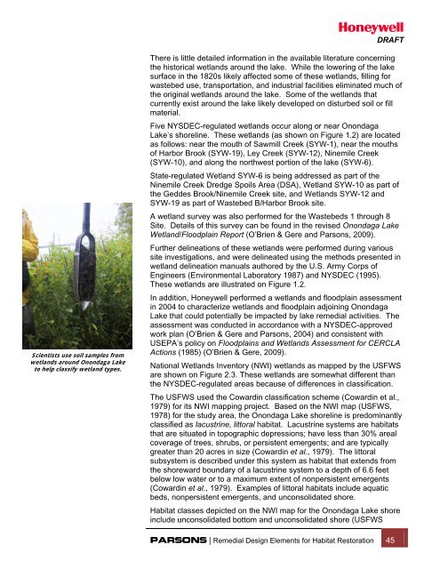
DRAFTScientists use soil samples fromwetlands around <strong>Onondaga</strong> <strong>Lake</strong>to help classify wetland types.There is little detailed information in the available literature concerningthe historical wetlands around the lake. While the lowering of the lakesurface in the 1820s likely affected some of these wetlands, filling forwastebed use, transportation, and industrial facilities eliminated much ofthe original wetlands around the lake. Some of the wetlands thatcurrently exist around the lake likely developed on disturbed soil or fillmaterial.Five NYSDEC-regulated wetlands occur along or near <strong>Onondaga</strong><strong>Lake</strong>’s shoreline. These wetlands (as shown on Figure 1.2) are locatedas follows: near the mouth of Sawmill Creek (SYW-1), near the mouthsof Harbor Brook (SYW-19), Ley Creek (SYW-12), Ninemile Creek(SYW-10), and along the northwest portion of the lake (SYW-6).State-regulated Wetland SYW-6 is being addressed as part of theNinemile Creek Dredge Spoils Area (DSA), Wetland SYW-10 as part ofthe Geddes Brook/Ninemile Creek site, and Wetlands SYW-12 andSYW-19 as part of Wastebed B/Harbor Brook site.A wetland survey was also performed for the Wastebeds 1 through 8Site. Details of this survey can be found in the revised <strong>Onondaga</strong> <strong>Lake</strong>Wetland/Floodplain Report (O’Brien & Gere and Parsons, 2009).Further delineations of these wetlands were performed during varioussite investigations, and were delineated using the methods presented inwetland delineation manuals authored by the U.S. Army Corps ofEngineers (Environmental Laboratory 1987) and NYSDEC (1995).These wetlands are illustrated on Figure 1.2.In addition, Honeywell performed a wetlands and floodplain assessmentin 2004 to characterize wetlands and floodplain adjoining <strong>Onondaga</strong><strong>Lake</strong> that could potentially be impacted by lake remedial activities. Theassessment was conducted in accordance with a NYSDEC-approvedwork plan (O’Brien & Gere and Parsons, 2004) and consistent withUSEPA’s policy on Floodplains and Wetlands Assessment for CERCLAActions (1985) (O’Brien & Gere, 2009).National Wetlands Inventory (NWI) wetlands as mapped by the USFWSare shown on Figure 2.3. These wetlands are somewhat different thanthe NYSDEC-regulated areas because of differences in classification.The USFWS used the Cowardin classification scheme (Cowardin et al.,1979) for its NWI mapping project. Based on the NWI map (USFWS,1978) for the study area, the <strong>Onondaga</strong> <strong>Lake</strong> shoreline is predominantlyclassified as lacustrine, littoral habitat. Lacustrine systems are habitatsthat are situated in topographic depressions; have less than 30% arealcoverage of trees, shrubs, or persistent emergents; and are typicallygreater than 20 acres in size (Cowardin et al., 1979). The littoralsubsystem is described under this system as habitat that extends fromthe shoreward boundary of a lacustrine system to a depth of 6.6 feetbelow low water or to a maximum extent of nonpersistent emergents(Cowardin et al., 1979). Examples of littoral habitats include aquaticbeds, nonpersistent emergents, and unconsolidated shore.<strong>Habitat</strong> classes depicted on the NWI map for the <strong>Onondaga</strong> <strong>Lake</strong> shoreinclude unconsolidated bottom and unconsolidated shore (USFWSPARSONS | Remedial Design Elements for <strong>Habitat</strong> Restoration 45