Habitat Plan 2 - Onondaga Lake Partnership
Habitat Plan 2 - Onondaga Lake Partnership
Habitat Plan 2 - Onondaga Lake Partnership

You also want an ePaper? Increase the reach of your titles
YUMPU automatically turns print PDFs into web optimized ePapers that Google loves.
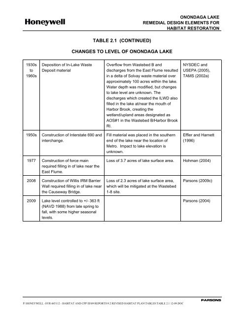
TABLE 2.1 (CONTINUED)CHANGES TO LEVEL OF ONONDAGA LAKEONONDAGA LAKEREMEDIAL DESIGN ELEMENTS FORHABITAT RESTORATION1930sto1960sDeposition of In-<strong>Lake</strong> WasteDeposit materialOverflow from Wastebed B anddischarges from the East Flume resultedin a delta of Solvay waste material overapproximately 100 acres within the lake.Water depth was modified, but changesto lake level are unknown. Thedischarges which created the ILWD alsofilled in the lake at/near the mouth ofHarbor Brook, creating thewetland/upland areas designated asAOS#1 in the Wastebed B/Harbor BrookRI.NYSDEC andUSEPA (2005),TAMS (2002a)1950sConstruction of Interstate 690 andinterchange.Fill material was placed in the southernend of the lake near the location ofMetro. Impact to lake elevation isunknown.Effler and Harnett(1996)1977 Construction of force mainrequired filling in of lake near theEast Flume.Loss of 3.7 acres of lake surface area. Hohman (2004)2008 Construction of Willis IRM BarrierWall required filling in of lake nearthe Causeway Bridge.2009 <strong>Lake</strong> level controlled to +/- 363 ft(NAVD 1988) from late spring tofall, with some higher seasonallevels.Loss of 2.3 acres of lake surface area,which will be mitigated at the Wastebed1-8 site.Parsons (2009c)Parsons (2004)P:\HONEYWELL -SYR\445112 - HABITAT AND CPP III\09 REPORTS\9.2 REVISED HABITAT PLAN\TABLES\TABLE 2.1 12-09.DOCPARSONS