

Level 2 Strategic Flood Risk Assessment (.pdf ... - Wigan Council
Level 2 Strategic Flood Risk Assessment (.pdf ... - Wigan Council
Level 2 Strategic Flood Risk Assessment (.pdf ... - Wigan Council

Create successful ePaper yourself
Turn your PDF publications into a flip-book with our unique Google optimized e-Paper software.
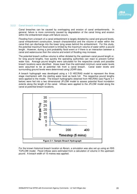
3.2.2 Canal breach methodologyCanal breaches can be caused by overtopping and erosion of canal embankments. Ingeneral, failure is more commonly caused by degradation of the canal lining and erosionwithin the embankment slope until failure occurs.<strong>Flood</strong>ing from a breach of a canal embankment is largely dictated by canal and ground levels,canal embankment construction, breach characteristics and the volume of water within thecanal that can discharge into the lower lying areas behind the embankment. For this study,the potential maximum flood extent is limited by the maximum volume of water within a poundlength. .However, during a joint probability flood event or if there is an interaction between acanal and watercourse then the volume and extent of flooding may increase.The potential breach outflow volume is either dictated by the upstream canal pound length or,for long pound lengths, how quickly the operating authorities can react to prevent furtherwater loss. Average pound lengths were calculated for the respective canals and possiblebreach locations were identified. Areas lower than the estimated minimum canal water levelswere assumed to be at potential risk from a canal breach. Canal water levels andsurrounding ground levels were determined using LIDAR data.A breach hydrograph was developed using a 1-D HECRAS model to represent the threestage mechanism with the starting water level as bank full. The respective pound lengthswere applied to the model. The breach hydrographs obtained from HECRAS (see Figure 3-1below) were fed into a two dimensional JFLOW model to assess potential flood inundationextents along the length of the canal. Inflows were applied to the JFLOW model along thecanal at potential breach locations.Figure 3-1: Sample Breach HydrographFor the known historical breach location at Abram, a simulation was also set up using an ISISTUFLOW model. <strong>Flood</strong> inflows were estimated from a calculation of volume in the upstreampound. A breach width of 15 metres was applied.2009s0578 Final SFRA with Environment Agency Comments - L2 Ver5 <strong>Wigan</strong>.doc 20


