

Level 2 Strategic Flood Risk Assessment (.pdf ... - Wigan Council
Level 2 Strategic Flood Risk Assessment (.pdf ... - Wigan Council
Level 2 Strategic Flood Risk Assessment (.pdf ... - Wigan Council

You also want an ePaper? Increase the reach of your titles
YUMPU automatically turns print PDFs into web optimized ePapers that Google loves.
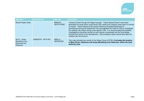
Map Name Map Reference Map Title DescriptionBreach Depth GridsBREACHDEPTH GRIDLiverpool Canal through the <strong>Wigan</strong> borough. "Canal Hazard Zones" have beengenerated for areas which could flood if the Leeds and Liverpool canal were to overtopor breach. These hazard zones should influence the spatial placement ofdevelopment during the Sequential Test and highlight the need for FRA to investigatethe residual risk further during a site-specific FRA. It is recommended that detailedinvestigations should be carried out and results incorporated into the final designfinished floor levels of the development. Site emergency plans should also take theresidual risk into account.Set O - AreasBenefiting fromDefences andDefences2009s0578 - D015-001ABDs &DEFENCESThis map indicates key results of the <strong>Wigan</strong> <strong>Council</strong> SFRA. It includes the locationof Main Rivers, Defences and Areas Benefiting from Defences, within the localauthority area.2009s0578 Final SFRA with Environment Agency Comments - L2 Ver5 <strong>Wigan</strong>.docXXIX


