2015 AACC Guide
- No tags were found...

Create successful ePaper yourself
Turn your PDF publications into a flip-book with our unique Google optimized e-Paper software.
Pine River Trail<br />
This new trail was unveiled in 2012. This trail starts<br />
at the Nottawasaga Fishing Park and exits at LeClair<br />
Soccer Park (Roth Street, Angus). Be sure to check out<br />
this trail - it provides visitors of the site with a peaceful<br />
setting that promotes a healthy community.<br />
Location: Angus<br />
Thornton-Cookstown Trans Canada Trail<br />
This 14 kilometre trail runs between the villages<br />
of Thornton and Cookstown and travels through<br />
green pasture land and forest and cross the<br />
Cookstown Creek. To view a map of the trail, visit<br />
www.essatownship.on.ca<br />
Location: Thornton & Cookstown<br />
Devil’s Glen Provincial Park<br />
Situated on the Niagara Escarpment 518 m above sea<br />
level this park features rock outcrops, forested slopes<br />
and wetlands, and protects a geologically significant<br />
incised river valley. Meltwater from the last retreating<br />
glacier carved the steep gorge of Devil’s Glen, where the<br />
Mad River now winds its irregular route. The park is<br />
gated and only accessible by foot. Camping and fires<br />
are not allowed. Access off of Highway 124 south of<br />
Duntroon, before Singhampton. This is an Ontario<br />
Provincial Park. For more information visit www.<br />
ontarioparks.com.<br />
Located between Singhampton and Glen Huron, ON<br />
Noisy River Provincial Nature Reserve<br />
Noisy River’s largely forested landscape is interrupted<br />
by a few meadows and a scenic portion of the Noisy<br />
River. Typical Niagara Escarpment features include<br />
cliffs, crevice caves, flat uplands, valley slopes and<br />
wetlands. There are no visitor facilities, but the Bruce<br />
Trail crosses this nature reserve. The park offers good<br />
hiking and nature appreciation opportunities. Access<br />
south of Dunedin off of County Rd 9. This is an<br />
Ontario Provincial Park. For more information visit<br />
www.ontarioparks.com.<br />
Location: Southwest of Dunedin, ON<br />
New Lowell Conservation Area<br />
New Lowell is home to a beautifully kept seasonal<br />
campground and a day-use park on Silver Birch Lake.<br />
Managed privately, the day-use park comes complete<br />
with a sandy beach, picnic areas and pavilion perfect for<br />
any size function. The Ganaraska Hiking Trail connects<br />
the park to Simcoe County’s forested area to the south.<br />
Entrance to the park is by admission on the weekends.<br />
More information on this park is available at www.nvca.<br />
on.ca<br />
Location: County Rd 9 to 2894 Hogback Rd in the village<br />
of New Lowell, ON<br />
Nottawasaga Bluffs Conservation Area<br />
With close to 400 acres of countryside vistas, hardwood<br />
and coniferous forests, open meadows and a series<br />
of caves, the Nottawasaga Bluffs offers a full day<br />
of exploration and adventure. Connect with the<br />
Bruce Trail as it makes its way through the property<br />
or venture down one of its side trails to catch a<br />
variety of unique features. Access 500 m left off of<br />
Nottawasaga 17/18 Sideroad east of Singhampton.<br />
Find more information on this park by visiting<br />
www.nvca.on.ca.<br />
Location: Nottawasaga 15/16 Sideroad south of<br />
Singhampton, ON<br />
Minesing Wetlands<br />
Designated as a wetland of international significance and<br />
spanning an area of more than 6,000 hectares (15,000<br />
acres), the Minesing Wetland is home to a diverse array<br />
of habitats. The unique assemblage of fens, marshes,<br />
swamps and bogs supports a network of sensitive flora<br />
and fauna, some rare or endangered. Willow Creek and<br />
the Nottawasaga River offer wonderful opportunities<br />
for short visits or longer trips by kayak or canoe, and a<br />
chance to spot some of the many waterfowl species that<br />
call this area home. A series of hiking trails are found in<br />
and around the wetlands, all of them offering unique<br />
glimpses into this wetland and its inhabitants. On foot,<br />
snowshoe or cross-country ski explore the Ganaraska,<br />
Trans Canada and McKinnon trails.<br />
Location: From the City of Barrie, go west on Hwy. 90<br />
(Dunlop St.) to George Johnston Rd. Travel north 8 km to<br />
the parking lot and canoe access on your left<br />
Bruce Trail<br />
The Bruce Trail, Canada’s oldest and longest marked<br />
footpath, provides the only continuous public access to<br />
the magnificent Niagara Escarpment, a UNESCO World<br />
Biosphere Reserve. Running along the Escarpment<br />
from Niagara to Tobermory, it spans more than 890 km<br />
of main Trail and over 400 km of associated side trails.<br />
The Bruce Trail Conservancy (BTC) is a charitable<br />
organization committed to establishing a conservation<br />
corridor containing a public footpath along the Niagara<br />
Escarpment, in order to protect its natural ecosystems<br />
and to promote environmentally responsible public<br />
access to this UNESCO World Biosphere Reserve. The<br />
BTC is one of Ontario’s largest land trusts, preserving<br />
over 8,000 acres of irreplaceable Niagara Escarpment<br />
landscape. For more information on hiking the trail<br />
please visit www.brucetrail.org<br />
Location: The Trail’s optimum route follows the natural<br />
edge of the Niagara Escarpment from Queenston in<br />
Niagara Falls to Tobermory. Visit website for access points.<br />
Ganaraska Trail<br />
The trail begins at a boulder opposite the town hall in<br />
Port Hope, located on the north shore of Lake Ontario.<br />
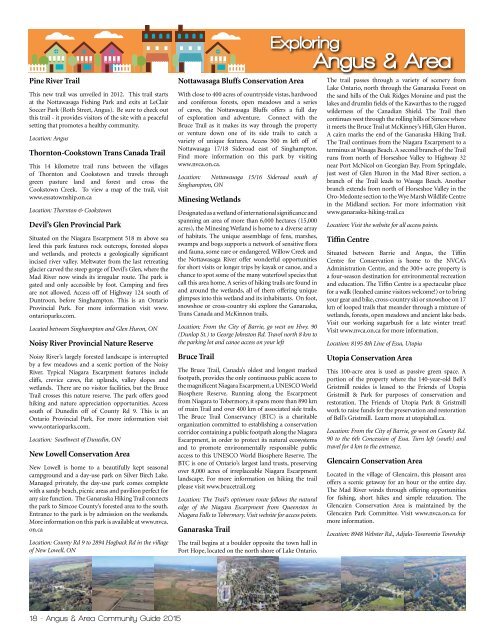
Exploring<br />
Angus & Area<br />
The trail passes through a variety of scenery from<br />
Lake Ontario, north through the Ganaraska Forest on<br />
the sand hills of the Oak Ridges Moraine and past the<br />
lakes and drumlin fields of the Kawarthas to the rugged<br />
wilderness of the Canadian Shield. The Trail then<br />
continues west through the rolling hills of Simcoe where<br />
it meets the Bruce Trail at McKinney’s Hill, Glen Huron.<br />
A cairn marks the end of the Ganaraska Hiking Trail.<br />
The Trail continues from the Niagara Escarpment to a<br />
terminus at Wasaga Beach. A second branch of the Trail<br />
runs from north of Horseshoe Valley to Highway 32<br />
near Port McNicol on Georgian Bay. From Springdale,<br />
just west of Glen Huron in the Mad River section, a<br />
branch of the Trail leads to Wasaga Beach. Another<br />
branch extends from north of Horseshoe Valley in the<br />
Oro-Medonte section to the Wye Marsh Wildlife Centre<br />
in the Midland section. For more information visit<br />
www.ganaraska-hiking-trail.ca<br />
Location: Visit the website for all access points.<br />
Tiffin Centre<br />
Situated between Barrie and Angus, the Tiffin<br />
Centre for Conservation is home to the NVCA’s<br />
Administration Centre, and the 300+ acre property is<br />
a four-season destination for environmental recreation<br />
and education. The Tiffin Centre is a spectacular place<br />
for a walk (leashed canine visitors welcome!) or to bring<br />
your gear and bike, cross-country ski or snowshoe on 17<br />
km of looped trails that meander through a mixture of<br />
wetlands, forests, open meadows and ancient lake beds.<br />
Visit our working sugarbush for a late winter treat!<br />
Visit www.nvca.on.ca for more information.<br />
Location: 8195 8th Line of Essa, Utopia<br />
Utopia Conservation Area<br />
This 100-acre area is used as passive green space. A<br />
portion of the property where the 140-year-old Bell’s<br />
Gristmill resides is leased to the Friends of Utopia<br />
Gristmill & Park for purposes of conservation and<br />
restoration. The Friends of Utopia Park & Gristmill<br />
work to raise funds for the preservation and restoration<br />
of Bell’s Gristmill. Learn more at utopiahall.ca.<br />
Location: From the City of Barrie, go west on County Rd.<br />
90 to the 6th Concession of Essa. Turn left (south) and<br />
travel for 4 km to the entrance. <br />
Glencairn Conservation Area<br />
Located in the village of Glencairn, this pleasant area<br />
offers a scenic getaway for an hour or the entire day.<br />
The Mad River winds through offering opportunities<br />
for fishing, short hikes and simple relaxation. The<br />
Glencairn Conservation Area is maintained by the<br />
Glencairn Park Committee. Visit www.nvca.on.ca for<br />
more information.<br />
Location: 8948 Webster Rd., Adjala-Tosorontio Township<br />
18 - Angus & Area Community <strong>Guide</strong> <strong>2015</strong>