Coastal Resource Guide Pleasant Bay and Chatham Harbor
Coastal Resource Guide Pleasant Bay and ... - Town to Chatham
Coastal Resource Guide Pleasant Bay and ... - Town to Chatham

Create successful ePaper yourself
Turn your PDF publications into a flip-book with our unique Google optimized e-Paper software.
<strong>Coastal</strong> <strong>Resource</strong> <strong>Guide</strong> for <strong>Pleasant</strong> <strong>Bay</strong> <strong>and</strong> <strong>Chatham</strong> <strong>Harbor</strong><br />
were located on a UMass tower twenty meters off the ground,<br />
near Arey’s Pond in Orleans. The data have been filtered by RERL’s<br />
quality control software, filtered to hourly average, <strong>and</strong> entered<br />
into Lakes Environmental Software WRPLOT View which is<br />
designed to created wind rose plots for meteorological data.<br />
The direction <strong>and</strong> intensity of estuarine wind energy has been<br />
depicted by a wind rose (Figure 8). The wind rose summarizes<br />
wind speed, duration <strong>and</strong> direction. Additional detail is provided<br />
by providing three roses, one annual average, one just for May<br />
through October, <strong>and</strong> one just for November through April.<br />
3.3.1 Findings - Inner Wave Climate<br />
The Orleans station has a broad, but fairly consistent, annual<br />
wind direction from the northwest to the southwest. Annually,<br />
approximately 70% of the time winds are between four <strong>and</strong><br />
eleven knots. The summer is characterized by lower wind speed<br />
<strong>and</strong> a dominant wind direction from the southwest. The winter is<br />
characterized by a northwest dominant wind direction <strong>and</strong> higher<br />
wind speeds. Summer winds only exceed twelve knots 6.6% of<br />
the time, compared to 21.5% for winter winds. The southwest<br />
winds do not happen as often in the winter as they do in the<br />
summer, but when they occur in the winter they are frequently<br />
stronger.<br />
<strong>Pleasant</strong> <strong>Bay</strong> is a complex estuarine system. In addition to an<br />
irregular shoreline, it contains numerous isl<strong>and</strong>s <strong>and</strong> mobile<br />
shoals, all of which may block or redirect surface winds <strong>and</strong>/or the<br />
resultant waves. The inner wind roses are not a perfect proxy for<br />
inner wave climate, however they illustrate the seasonality of the<br />
wind, which drives wave generation within <strong>Pleasant</strong> <strong>Bay</strong>. A later<br />
section (4.3 - Longshore Sediment Transport) further discusses<br />
inner wave climate as it relates to sediment transport.<br />
3.4 Tidal Cycle in <strong>Pleasant</strong> <strong>Bay</strong> <strong>and</strong> <strong>Chatham</strong> <strong>Harbor</strong><br />
Tides within the <strong>Pleasant</strong> <strong>Bay</strong> <strong>and</strong> <strong>Chatham</strong> <strong>Harbor</strong> estuary are<br />
semi-diurnal (two tidal cycles per day) with an average range of<br />
somewhat less than six feet in <strong>Chatham</strong> <strong>Harbor</strong> <strong>and</strong> about four<br />
<strong>and</strong> one-half feet at Meetinghouse Pond in Orleans at the very<br />
head of Little <strong>Pleasant</strong> <strong>Bay</strong> (Figure 9). These tides are produced<br />
by the open continental shelf (Gulf of Maine) tides which, as they<br />
rise <strong>and</strong> fall, cause seawater to flow into <strong>and</strong> out of the estuary<br />
through the tidal inlets that connect the two systems.<br />
Passage of the tidal wave through the inlets <strong>and</strong> inner channels<br />
delays <strong>and</strong> distorts the estuary’s tides. While high tide at <strong>Chatham</strong><br />
<strong>Harbor</strong> occurs less than an hour following Boston high tide (Boston<br />
is the location of the region’s tidal reference station), <strong>Chatham</strong>’s<br />
low tide occurs more than an hour after Boston’s low. At<br />
Meetinghouse Pond the delay <strong>and</strong> distortion are greater. Highs <strong>and</strong><br />
lows occur about two <strong>and</strong> one-half <strong>and</strong> three <strong>and</strong> one-half hours,<br />
respectively, after those at Boston.<br />
reducing ranges <strong>and</strong> increasing phase lags (time delay between<br />
the Boston <strong>and</strong> local tides) over most of the 21 st Century.<br />
This discussion has concerned “astronomical” or “predicted” tides<br />
in the estuary, but the actual water level at any time <strong>and</strong> place<br />
may differ markedly from the predicted tides due to atmospheric<br />
conditions. A common example would be the effect of storm<br />
surges along the outer coast, but even greater anomalies can<br />
result from direct wind stress acting along the length of the<br />
system, either “setting-up” or “setting-down” the water level,<br />
especially in the ponds <strong>and</strong> narrows.<br />
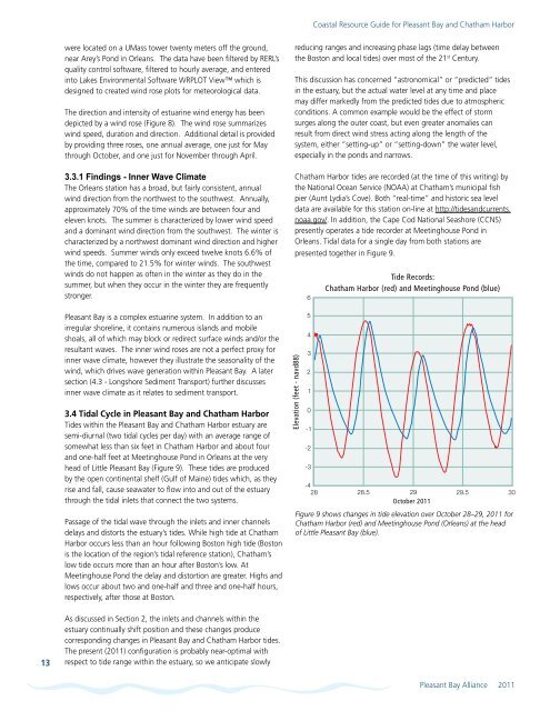
<strong>Chatham</strong> <strong>Harbor</strong> tides are recorded (at the time of this writing) by<br />
the National Ocean Service (NOAA) at <strong>Chatham</strong>’s municipal fish<br />
pier (Aunt Lydia’s Cove). Both “real-time” <strong>and</strong> historic sea level<br />
data are available for this station on-line at http://tides<strong>and</strong>currents.<br />
noaa.gov/. In addition, the Cape Cod National Seashore (CCNS)<br />
presently operates a tide recorder at Meetinghouse Pond in<br />
Orleans. Tidal data for a single day from both stations are<br />
presented together in Figure 9.<br />
Elevation (feet - navd88)<br />
6<br />
5<br />
4<br />
3<br />
2<br />
1<br />
0<br />
-1<br />
-2<br />
-3<br />
-4<br />
28<br />
Tide Records:<br />
<strong>Chatham</strong> <strong>Harbor</strong> (red) <strong>and</strong> Meetinghouse Pond (blue)<br />
28.5 29 29.5 30<br />
October 2011<br />
Figure 9 shows changes in tide elevation over October 28–29, 2011 for<br />
<strong>Chatham</strong> <strong>Harbor</strong> (red) <strong>and</strong> Meetinghouse Pond (Orleans) at the head<br />
of Little <strong>Pleasant</strong> <strong>Bay</strong> (blue).<br />
13<br />
As discussed in Section 2, the inlets <strong>and</strong> channels within the<br />
estuary continually shift position <strong>and</strong> these changes produce<br />
corresponding changes in <strong>Pleasant</strong> <strong>Bay</strong> <strong>and</strong> <strong>Chatham</strong> <strong>Harbor</strong> tides.<br />
The present (2011) configuration is probably near-optimal with<br />
respect to tide range within the estuary, so we anticipate slowly<br />
<strong>Pleasant</strong> <strong>Bay</strong> Alliance 2011