Coastal Resource Guide Pleasant Bay and Chatham Harbor
Coastal Resource Guide Pleasant Bay and ... - Town to Chatham
Coastal Resource Guide Pleasant Bay and ... - Town to Chatham

Create successful ePaper yourself
Turn your PDF publications into a flip-book with our unique Google optimized e-Paper software.
<strong>Coastal</strong> <strong>Resource</strong> <strong>Guide</strong> for <strong>Pleasant</strong> <strong>Bay</strong> <strong>and</strong> <strong>Chatham</strong> <strong>Harbor</strong><br />
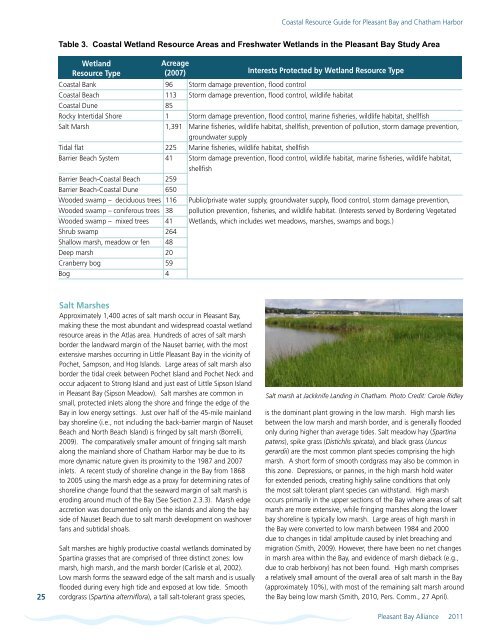
Table 3. <strong>Coastal</strong> Wetl<strong>and</strong> <strong>Resource</strong> Areas <strong>and</strong> Freshwater Wetl<strong>and</strong>s in the <strong>Pleasant</strong> <strong>Bay</strong> Study Area<br />
Wetl<strong>and</strong><br />
<strong>Resource</strong> Type<br />
Acreage<br />
(2007) Interests Protected by Wetl<strong>and</strong> <strong>Resource</strong> Type<br />
<strong>Coastal</strong> Bank 96 Storm damage prevention, flood control<br />
<strong>Coastal</strong> Beach 113 Storm damage prevention, flood control, wildlife habitat<br />
<strong>Coastal</strong> Dune 85<br />
Rocky Intertidal Shore 1 Storm damage prevention, flood control, marine fisheries, wildlife habitat, shellfish<br />
Salt Marsh<br />
1,391 Marine fisheries, wildlife habitat, shellfish, prevention of pollution, storm damage prevention,<br />
groundwater supply<br />
Tidal flat 225 Marine fisheries, wildlife habitat, shellfish<br />
Barrier Beach System 41 Storm damage prevention, flood control, wildlife habitat, marine fisheries, wildlife habitat,<br />
shellfish<br />
Barrier Beach-<strong>Coastal</strong> Beach 259<br />
Barrier Beach-<strong>Coastal</strong> Dune 650<br />
Wooded swamp – deciduous trees 116 Public/private water supply, groundwater supply, flood control, storm damage prevention,<br />
Wooded swamp – coniferous trees 38 pollution prevention, fisheries, <strong>and</strong> wildlife habitat. (Interests served by Bordering Vegetated<br />
Wooded swamp – mixed trees 41 Wetl<strong>and</strong>s, which includes wet meadows, marshes, swamps <strong>and</strong> bogs.)<br />
Shrub swamp 264<br />
Shallow marsh, meadow or fen 48<br />
Deep marsh 20<br />
Cranberry bog 59<br />
Bog 4<br />
25<br />
Salt Marshes<br />
Approximately 1,400 acres of salt marsh occur in <strong>Pleasant</strong> <strong>Bay</strong>,<br />
making these the most abundant <strong>and</strong> widespread coastal wetl<strong>and</strong><br />
resource areas in the Atlas area. Hundreds of acres of salt marsh<br />
border the l<strong>and</strong>ward margin of the Nauset barrier, with the most<br />
extensive marshes occurring in Little <strong>Pleasant</strong> <strong>Bay</strong> in the vicinity of<br />
Pochet, Sampson, <strong>and</strong> Hog Isl<strong>and</strong>s. Large areas of salt marsh also<br />
border the tidal creek between Pochet Isl<strong>and</strong> <strong>and</strong> Pochet Neck <strong>and</strong><br />
occur adjacent to Strong Isl<strong>and</strong> <strong>and</strong> just east of Little Sipson Isl<strong>and</strong><br />
in <strong>Pleasant</strong> <strong>Bay</strong> (Sipson Meadow). Salt marshes are common in<br />
small, protected inlets along the shore <strong>and</strong> fringe the edge of the<br />
<strong>Bay</strong> in low energy settings. Just over half of the 45-mile mainl<strong>and</strong><br />
bay shoreline (i.e., not including the back-barrier margin of Nauset<br />
Beach <strong>and</strong> North Beach Isl<strong>and</strong>) is fringed by salt marsh (Borrelli,<br />
2009). The comparatively smaller amount of fringing salt marsh<br />
along the mainl<strong>and</strong> shore of <strong>Chatham</strong> <strong>Harbor</strong> may be due to its<br />
more dynamic nature given its proximity to the 1987 <strong>and</strong> 2007<br />
inlets. A recent study of shoreline change in the <strong>Bay</strong> from 1868<br />
to 2005 using the marsh edge as a proxy for determining rates of<br />
shoreline change found that the seaward margin of salt marsh is<br />
eroding around much of the <strong>Bay</strong> (See Section 2.3.3). Marsh edge<br />
accretion was documented only on the isl<strong>and</strong>s <strong>and</strong> along the bay<br />
side of Nauset Beach due to salt marsh development on washover<br />
fans <strong>and</strong> subtidal shoals.<br />
Salt marshes are highly productive coastal wetl<strong>and</strong>s dominated by<br />
Spartina grasses that are comprised of three distinct zones: low<br />
marsh, high marsh, <strong>and</strong> the marsh border (Carlisle et al, 2002).<br />
Low marsh forms the seaward edge of the salt marsh <strong>and</strong> is usually<br />
flooded during every high tide <strong>and</strong> exposed at low tide. Smooth<br />
cordgrass (Spartina alterniflora), a tall salt-tolerant grass species,<br />
Salt marsh at Jackknife L<strong>and</strong>ing in <strong>Chatham</strong>. Photo Credit: Carole Ridley<br />
is the dominant plant growing in the low marsh. High marsh lies<br />
between the low marsh <strong>and</strong> marsh border, <strong>and</strong> is generally flooded<br />
only during higher than average tides. Salt meadow hay (Spartina<br />
patens), spike grass (Distichlis spicata), <strong>and</strong> black grass (Juncus<br />
gerardii) are the most common plant species comprising the high<br />
marsh. A short form of smooth cordgrass may also be common in<br />
this zone. Depressions, or pannes, in the high marsh hold water<br />
for extended periods, creating highly saline conditions that only<br />
the most salt tolerant plant species can withst<strong>and</strong>. High marsh<br />
occurs primarily in the upper sections of the <strong>Bay</strong> where areas of salt<br />
marsh are more extensive, while fringing marshes along the lower<br />
bay shoreline is typically low marsh. Large areas of high marsh in<br />
the <strong>Bay</strong> were converted to low marsh between 1984 <strong>and</strong> 2000<br />
due to changes in tidal amplitude caused by inlet breaching <strong>and</strong><br />
migration (Smith, 2009). However, there have been no net changes<br />
in marsh area within the <strong>Bay</strong>, <strong>and</strong> evidence of marsh dieback (e.g.,<br />
due to crab herbivory) has not been found. High marsh comprises<br />
a relatively small amount of the overall area of salt marsh in the <strong>Bay</strong><br />
(approximately 10%), with most of the remaining salt marsh around<br />
the <strong>Bay</strong> being low marsh (Smith, 2010, Pers. Comm., 27 April).<br />
<strong>Pleasant</strong> <strong>Bay</strong> Alliance 2011