Open Air Business November/December 2016
The UK's outdoor hospitality business magazine for function venues, glampsites and event organisers
The UK's outdoor hospitality business magazine for function venues, glampsites and event organisers

You also want an ePaper? Increase the reach of your titles
YUMPU automatically turns print PDFs into web optimized ePapers that Google loves.
EVENTS<br />
A Q&A with Rik Haines of Tarren Production on how to critique the viability<br />
of a site for an outdoor event, and how to create a site plan<br />
BE IT A festival, country show or<br />
charity event, most outdoor events<br />
of any notable size are likely be to<br />
be held on land not designed to<br />
host them. As part of their early<br />
planning, event organisers need to<br />
identify a location for their event<br />
that fulfils their aspirations. There<br />
is much to consider in assessing<br />
a site’s suitability for a particular<br />
event and then planning how best<br />
to configure it.<br />
<strong>Open</strong> <strong>Air</strong> <strong>Business</strong> asked for<br />
some advice from Rik Haines, the<br />
senior event producer at Tarren<br />
Production.<br />
Why is venue assessment<br />
imperative when planning an<br />
outdoor event?<br />
The main purpose of a venue<br />
assessment is to understand how<br />
suitable a particular site is for a<br />
particular event. We would look<br />
at the size of the site, its location,<br />
any existing infrastructure and<br />
its natural features (woodland,<br />
gradients, water etc.). The<br />
feasibility study also considers<br />
the best use of the space for<br />
positioning of infrastructure<br />
(stages / bars / markets etc.) and<br />
how suppliers and contractors<br />
can access the site with minimal<br />
disruption to land or neighbours.<br />
These early findings would<br />
inform whether a particular site<br />
would work for the event. After<br />
these initial considerations we<br />
would look at how guests would<br />
get to the event (proximity to train<br />
stations / major roads etc.) as well<br />
as working out the amount of<br />
space available for parking. Ideally<br />
we would do this without having<br />
to get in additional trackway as<br />
these costs would then push up<br />
the overall budget for the event. If<br />
camping is required we would look<br />
at how much space was available<br />
for this and how we could split each<br />
camp section up (crew / family /<br />
general camping etc.).<br />
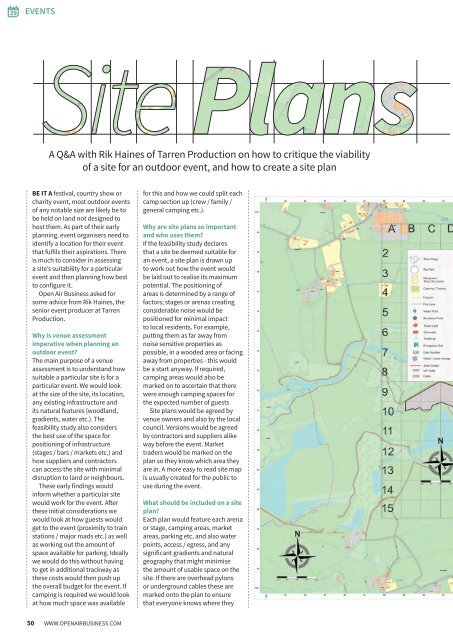
Why are site plans so important<br />
and who uses them?<br />
If the feasibility study declares<br />
that a site be deemed suitable for<br />
an event, a site plan is drawn up<br />
to work out how the event would<br />
be laid out to realise its maximum<br />
potential. The positioning of<br />
areas is determined by a range of<br />
factors; stages or arenas creating<br />
considerable noise would be<br />
positioned for minimal impact<br />
to local residents. For example,<br />
putting them as far away from<br />
noise sensitive properties as<br />
possible, in a wooded area or facing<br />
away from properties - this would<br />
be a start anyway. If required,<br />
camping areas would also be<br />
marked on to ascertain that there<br />
were enough camping spaces for<br />
the expected number of guests<br />
Site plans would be agreed by<br />
venue owners and also by the local<br />
council. Versions would be agreed<br />
by contractors and suppliers alike<br />
way before the event. Market<br />
traders would be marked on the<br />
plan so they know which area they<br />
are in. A more easy to read site map<br />
is usually created for the public to<br />
use during the event.<br />
What should be included on a site<br />
plan?<br />
Each plan would feature each arena<br />
or stage, camping areas, market<br />
areas, parking etc, and also water<br />
points, access / egress, and any<br />
significant gradients and natural<br />
geography that might minimise<br />
the amount of usable space on the<br />
site. If there are overhead pylons<br />
or underground cables these are<br />
marked onto the plan to ensure<br />
that everyone knows where they<br />
50 WWW.OPENAIRBUSINESS.COM