Energiforsyning i Arktis – hvilken vej vælger Grønland? - Artek ...
Energiforsyning i Arktis – hvilken vej vælger Grønland? - Artek ...
Energiforsyning i Arktis – hvilken vej vælger Grønland? - Artek ...

Create successful ePaper yourself
Turn your PDF publications into a flip-book with our unique Google optimized e-Paper software.
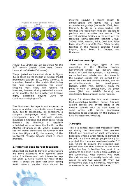
Figure 4.2: Arctic sea ice projection for the<br />
21 st century (Walsh, 2010, Pers. Comm.<br />
University of Alaska Fairbanks).<br />
The projected sea ice extent shown in Figure<br />
4.2 is based on the median of several model<br />
predictions (Walsh, 2010, Pers. Comm.). It<br />
is evident, based on the models, that during<br />
the next several decades, the winter<br />
shipping most likely will require ice<br />
breakers, however during extended summer<br />
or fall months, the Arctic water will become<br />
highly accessible beyond 2040 for<br />
continuous shipping traffic.<br />
The Northwest Passage is not expected to<br />
become a viable trans-Arctic route through<br />
2020 due to seasonality, ice conditions, a<br />
complex archipelago, draft restrictions,<br />
chokepoints, lack of adequate charts,<br />
insurance limitations and other costs, which<br />
diminish the likelihood of regularly<br />
scheduled services from the Pacific to the<br />
Atlantic (Brigham et al., 2009). Based on<br />
sea ice model predictions for further in the<br />
time line (Figure 4.2); the opening of the<br />
Northwest Passage beyond 2020 is more<br />
probable.<br />
5. Potential deep harbor locations<br />
Ships that are built to travel in Arctic waters<br />
are more expensive than general cargo<br />
ships. It is the owners’ main interest to keep<br />
the ships in Arctic waters for most of the<br />
time. It brings the point that after leaving<br />
Arctic waters, another ship should be<br />
45<br />
involved (maybe a larger cargo) to<br />
unload/upload the goods into a less<br />
expensive cargo ship (Hemsath, 2009, Pers.<br />
Comm.). To do so, a deep harbor with<br />
facilities and equipment that are capable to<br />
perform such activities are crucial. The<br />
current docking facilities in the area are the<br />
following (NUKA Research Planning Group,<br />
2004): Adak, Akutan, Atka, Cold Bay, False<br />
Pass, King Cove, and St. Paul. Other docking<br />
facilities in the Aleutian Islands: Nelson<br />
Lagoon, Sand Point, St. George, and<br />
Unalaska.<br />
6. Land ownership<br />
There are four major types of land<br />
ownership in the Aleutian Islands.<br />
Government owned, e.g. military base,<br />
Bureau of Land Management; state owned;<br />
native land and private land. Any areas in<br />
the Aleutian Islands that are owned by or<br />
under the Fish and Wildlife Service, are not<br />
permitted/available for development<br />
(Garcia, 2010, Pers. Comm.). From the<br />
point of view of development, the green<br />
areas (Fish and Wildlife Service) are<br />
significantly large areas in some regions.<br />
Figure 6.1 shows the four most common<br />
land ownerships (military, native, fish and<br />
wildlife service and private land) in the<br />
Aleutian Islands, with the main focus on<br />
some areas with proven geothermal<br />
resources (data available on the Bureau of<br />
Land Management website).<br />
7. People<br />
This is a general topic that frequently came<br />
up during the interviews. The Aleutian<br />
Islands are composed of small settlements.<br />
Especially when a larger facility is planned to<br />
be built, are there enough people locally for<br />
a project like the ones mentioned earlier? If<br />
not, where to acquire the required man<br />
power? One idea that surfaced is the model<br />
of Prudhoe Bay. In Prudhoe Bay, most of the<br />
workforce comprise if people from outside of<br />
the community. Most workers who work<br />
there do so on a bi-weekly basis with two<br />
weeks on and two weeks off. They live<br />
somewhere else, like Fairbanks, Anchorage,<br />
or even as far as the lower 48 states.