Tracking Ocean Wanders (PDF, 5 MB) - BirdLife International
Tracking Ocean Wanders (PDF, 5 MB) - BirdLife International
Tracking Ocean Wanders (PDF, 5 MB) - BirdLife International

You also want an ePaper? Increase the reach of your titles
YUMPU automatically turns print PDFs into web optimized ePapers that Google loves.
<strong>Tracking</strong> ocean wanderers: the global distribution of albatrosses and petrels – Methods<br />
2.2.2 Deriving density distribution maps<br />
In order to identify areas which are highly utilised by<br />
albatrosses and petrels, some indication of density needs to<br />
be derived from the PTT tracking data. However the<br />
sampling regime of these data is dependent on several<br />
factors: the speed at which the bird is travelling, its latitude<br />
(Georges et al. 1997), and the performance of the device<br />
itself. In order to provide a more regular sampling regime it<br />
was assumed that a bird flew in a straight line at constant<br />
velocity between two successive uplinks, where these uplinks<br />
were less than 24 hours apart. The path of the bird was then<br />
resampled at hourly intervals, any remaining time being<br />
added to the first segment of the next path between<br />
successive uplinks. If the interval between uplinks was more<br />
than 24 hours, no assumptions were made about the bird’s<br />
behaviour and these paths were not resampled. In this way<br />
devices with long duty cycles were also catered for as no<br />
assumptions were made about the bird’s location during<br />
‘OFF’ cycles. The resampling method also ensured that each<br />
trip was weighted by its duration when calculating density<br />
distributions. The process produced locations for the<br />
individual at hourly intervals, and thus density distribution<br />
maps derived from these locations were indicative of time<br />
spent (‘bird hours’) in a particular area.<br />
Albatrosses and petrels are central place foragers when<br />
breeding, so in any density distribution map the uplinks around<br />
the colony could potentially outweigh any more distant<br />
foraging area. If the commuting points to and from foraging<br />
areas are removed, this high density around the colony should<br />
be reduced. However this requires making assumptions about<br />
the bird’s activity based solely on the tracking data. In addition,<br />
commuting birds could still be at risk from fisheries interactions<br />
if they encounter a fishing vessel and stop to forage. To assess<br />
the effect of excluding commuting data, foraging points for<br />
Wandering Albatrosses were assumed to be those resampled<br />
points occurring between sunrise and sunset where the<br />
velocity was less than 20 km/hr. By excluding all other<br />
points, a density distribution of foraging locations was<br />
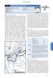
produced. This did not noticeably reduce the density around<br />
the colony, and there was little difference in areas of importance<br />
(Figure 2.2). Therefore foraging and commuting points<br />
were not separated out in the final maps. It is thus recognised<br />
that not all ‘hot spots’ identified by the kernel analysis will<br />
be foraging areas, but they still represent areas of risk.<br />
Kernel density estimators have been successfully used in<br />
several tracking studies to quantify habitat use and identify<br />
home ranges (e.g. Wood et al. 2000). The single most<br />
important step when using these estimators is the selection<br />
of the smoothing (or h) parameter. This can greatly<br />
influence the home range size and can also highlight or<br />
smooth over areas of high density (Annex 3), so it is<br />
necessary to explicitly report the methods used to ensure<br />
transparency and objectivity. Care needs to be taken when<br />
comparing different datasets, but current experience and<br />
practice is encouraging (e.g. Matthiopoulos 2003).<br />
As this study does not attempt to estimate range sizes,<br />
aiming instead to identify core areas of utilisation for<br />
conservation manage-ment, the selection of h was done by<br />
identifying the smallest practical unit of management on<br />
the high seas. For present purposes the workshop<br />
participants agreed this to be a 1 degree grid square.<br />
Although the use of 1 degree as a smoothing parameter<br />
means the shape of the kernel will vary with changes in<br />
latitude, it was agreed that the effects of this would be small<br />
in relation to the scales at which the data would be<br />
presented, and that this latitude-related distortion is widely<br />
understood.<br />
Kernel density distribution maps were derived using the<br />
kernel function in ArcGIS 8.2. The grid size was set at onetenth<br />
of the value of h i.e. 0.1 of a degree. If sample sizes<br />
were sufficiently large, separate kernel density distribution<br />
maps were produced for birds of different ages (juvenile,<br />
adult), breeding status, sex and breeding stage.<br />
2.2.3 Combining density grids (weighting)<br />
The density grids derived by kernel analysis of the<br />
resampled PTT locations for each part of the population<br />
were adjusted to reflect an index of ‘seabird at sea hours’ as<br />
follows: the kernel density estimate of each cell was divided<br />
by the number of resampled PTT locations for the dataset,<br />
and then weighted by the number of individuals at sea for<br />
that particular colony and breeding status/stage (e.g. Figure<br />
Figure 2.2. Kernel density distribution contours of breeding Wandering Albatrosses tracked from Iles Crozet, showing density contours using<br />
all locations (A) and foraging locations only (B).<br />
5