Tracking Ocean Wanders (PDF, 5 MB) - BirdLife International
Tracking Ocean Wanders (PDF, 5 MB) - BirdLife International
Tracking Ocean Wanders (PDF, 5 MB) - BirdLife International

You also want an ePaper? Increase the reach of your titles
YUMPU automatically turns print PDFs into web optimized ePapers that Google loves.
54<br />
<strong>Tracking</strong> ocean wanderers: the global distribution of albatrosses and petrels – Discussion<br />
5.2.2 Relationships between distribution of<br />
albatrosses and petrels and the Statistical<br />
Areas of the Food and Agriculture<br />
Organisation of the United Nations (FAO)<br />
Much fisheries information, including catch and effort data<br />
for many fisheries which have potential for bycatch of<br />
albatrosses and petrels, is still provided only at the scale of<br />
FAO Statistical Areas (Figure 5.4) and subdivisions of<br />
these. While any analysis and comparison with seabird data<br />
at these scales is likely to be too coarse to be of much use in<br />
management contexts, nevertheless it may represent the<br />
lowest common denominator for some data compilations<br />
and comparisons, at least for the time being.<br />
To indicate the scale and nature of potential<br />
comparisons with albatross and petrel range data, we<br />
provide simple depictions, using breeding phase data only<br />
(Figure 5.5), tabulated in Table 5.1 and summarised on a<br />
species-specific basis in Figure 5.6.<br />
The basic comparisons by area (Figure 5.5, Table 5.1)<br />
emphasise the importance of five main regions: (a) north<br />
Pacific (FAO areas 77, 67 and 61 in order of priority); (b)<br />
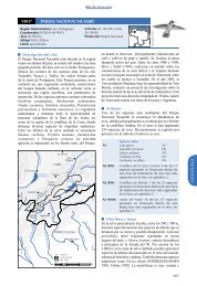
Figure 5.4. Map of the Food<br />
and Agriculture Organisation<br />
of the United Nation’s (FAO)<br />
Statistical Areas.<br />
Figure 5.5. Global utilisation distributions (UD’s) of breeding albatrosses in relation to the FAO Statistical Areas. A UD provides a probability<br />
contour indicating the relative amount of time birds spend in a particular area i.e. they will spend 50% of their time within the 50% UD. The<br />
dotted line represents the entire range, or 100% UD. This composite was created by calculating the utilisation distributions for each species<br />
and combining them giving each species equal weighting. UD’s for each species were derived from density distribution maps obtained by<br />
satellite tracking of breeding birds of the following 16 species from these locations: Amsterdam Albatross (Amsterdam Island), Antipodean<br />
(Gibson’s) Albatross (Auckland Islands), Black-browed Albatross (Isla Diego de Almagro, Islas Ildefonso, Islas Diego Ramirez, Falkland Islands<br />
(Malvinas), South Georgia and Iles Kerguelen), Black-footed Albatross (Tern Island), Buller’s Albatross (Solander Island and Snares Islands),<br />
Chatham Albatross (Chatham Islands), Grey-headed Albatross (Islas Ildefonso, Islas Diego Ramirez, South Georgia, Marion Island, Campbell<br />
Island and Macquarie Island), Light-mantled Albatross (Macquarie Island), Laysan Albatross (Tern Island and Isla de Guadalupe), Northern Royal<br />
Albatross (Chatham Islands and Taiaroa Head), Southern Royal Albatross (Campbell Island), Shy Albatross (Albatross Island, Mewstone and Pedra<br />
Branca), Sooty Albatross (Iles Crozet), Tristan Albatross (Gough Island), Wandering Albatross (South Georgia, Marion Island, Iles Crozet and Iles<br />
Kerguelen) and Indian Yellow-nosed Albatross (Amsterdam Island).