WCN_Dec17WEB

You also want an ePaper? Increase the reach of your titles
YUMPU automatically turns print PDFs into web optimized ePapers that Google loves.
Continued from Page 17<br />
time, it is a slower process and results in<br />
a less dense set of data point. The EM38<br />
is a smaller device that can be carried<br />
by hand. This allows it to be used in<br />
a variety of situations. There are also<br />
researchers that believe that the electromagnetic<br />
is a more reliable measure of<br />
conductivity.<br />
When using either system, GPS<br />
should be used to record the location of<br />
each data point. Dataloggers are used<br />
to record the two different values and<br />
combined with a location from a GPS<br />
receiver. These values can be mapped for<br />
a visualization of soil variability. Georeferencing<br />
of the mS/m is important as<br />
it allows the transfer of the data in text<br />
format and onto a GIS for mapping.<br />
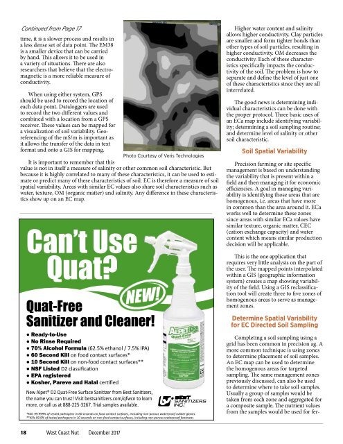
Photo Courtesy of Veris Technologies<br />
It is important to remember that this<br />
value is not in itself a measure of salinity or other common soil characteristic. But<br />
because it is highly correlated to many of these characteristics, it can be used to estimate<br />
or predict many of these characteristics of soil. EC is therefore a measure of soil<br />
spatial variability. Areas with similar EC values also share soil characteristics such as<br />
water, texture, OM (organic matter) and salinity. Any difference in these characteristics<br />
show up on an EC map.<br />
Can’t Use<br />
Quat?<br />
Quat-Free<br />
Sanitizer and Cleaner!<br />
● Ready-to-Use<br />
● No Rinse Required<br />
● 70% Alcohol Formula (62.5% ethanol / 7.5% IPA)<br />
● 60 Second Kill on food contact surfaces*<br />
● 10 Second Kill on non-food contact surfaces**<br />
● NSF Listed D2 classification<br />
● EPA registered<br />
● Kosher, Pareve and Halal certified<br />
New Alpet® D2 Quat-Free Surface Sanitizer from Best Sanitizers,<br />
the name you can trust! Visit bestsanitizers.com/qfwcn to learn<br />
more, or call us at 888-225-3267. Trial samples available.<br />
*Kills 99.999% of tested pathogens in 60 seconds on food contact surfaces, including non-porous waterproof rubber gloves.<br />
**Kills 99.9% of tested pathogens in 10 seconds on non-food contact surfaces, including non-porous waterproof footwear.<br />
Higher water content and salinity<br />
allows higher conductivity. Clay particles<br />
are smaller and form tighter bonds than<br />
other types of soil particles, resulting in<br />
higher conductivity. OM decreases the<br />
conductivity. Each of these characteristics<br />
specifically impacts the conductivity<br />
of the soil. The problem is how to<br />
separate and define the level of just one<br />
of these characteristics since they are all<br />
interrelated.<br />
The good news is determining individual<br />
characteristics can be done with<br />
the proper protocol. Three basic uses of<br />
an ECa map include identifying variability;<br />
determining a soil sampling routine;<br />
and determine level of salinity or other<br />
soil characteristic.<br />
Soil Spatial Variability<br />
Precision farming or site specific<br />
management is based on understanding<br />
the variability that is present within a<br />
field and then managing it for economic<br />
efficiencies. A goal in managing variability<br />
is identifying those areas that are<br />
homogenous, i.e. areas that have more<br />
in common than the area around it. ECa<br />
works well to determine these zones<br />
since areas with similar ECa values have<br />
similar texture, organic matter, CEC<br />
(cation exchange capacity) and water<br />
content which means similar production<br />
decision will be applicable.<br />
This is the one application that<br />
requires very little analysis on the part of<br />
the user. The mapped points interpolated<br />
within a GIS (geographic information<br />
system) creates a map showing variability<br />
of the field. Using a GIS reclassification<br />
tool will create three to five zones of<br />
homogenous areas to serve as management<br />
zones.<br />
Determine Spatial Variability<br />
for EC Directed Soil Sampling<br />
Completing a soil sampling using a<br />
grid has been common in precision ag. A<br />
more common technique is using zones<br />
to determine placement of soil samples.<br />
An EC map can be used to determine<br />
the homogenous areas for targeted<br />
sampling. The same management zones<br />
previously discussed, can also be used<br />
to determine where to take soil samples.<br />
Usually a group of samples would be<br />
taken from each zone and aggregated for<br />
a composite sample. The nutrient values<br />
from the samples would be used for fer-<br />
18 West Coast Nut December 2017