2019 Super Camping

You also want an ePaper? Increase the reach of your titles
YUMPU automatically turns print PDFs into web optimized ePapers that Google loves.
The Cariboo<br />
This is a land born of dreams of<br />
discovery, yellow dust and instant<br />
riches, with the “Cariboo Gold Rush<br />
Trail” traversing through this region.<br />
In 1862, Billy Barker struck gold<br />
near Barkerville on Williams Creek,<br />
which started a rush of adventurers<br />
from around the globe traversing<br />
the difficult terrain of this now<br />
famous Gold Rush Trail, begins in<br />
New Westminster in the south, to its<br />
terminus in Barkerville – a National<br />
Historic Site and home to 150<br />
restored 1860’s buildings. The rush<br />
for gold exploration, panning and<br />
mining are still active today. Visitors<br />
from around the world still follow in<br />
the footsteps of prior expeditions.<br />
Interesting roadhouses and museums<br />
still stand where stagecoaches once<br />
stopped. Highway 97, the main<br />
north/south corridor through the<br />
region, is also the key north to Alaska<br />
route. Plan your family adventure<br />
this summer and include summer<br />
festivals, watersports, mountain<br />
biking, hiking and wildlife viewing<br />
activities along the way.<br />
The Chilcotin<br />
Accessed by road on Highway 20<br />
(The Freedom Hwy) or by sea on the<br />
Northern Sea Wolf from Vancouver<br />
Island to Bella Coola, the Chilcotin is<br />
a land of dramatic scenery, rugged<br />
landscapes and thick forests. Here,<br />
BC’s highest mountain, Mount<br />
Waddington, rises 4,016 meters. The<br />
jagged central coast Mountain peaks<br />
in the Chilcotin are covered in vast<br />
ice fields and wide alpine meadows,<br />
gradually softening into large valleys,<br />
rolling foothills, pine covered forests,<br />
lakes and rivers and the grasslands of<br />
the Chilcotin Plateau. Along the way<br />
discover some of the best fishing<br />
lakes and rivers to be found in North<br />
America. Nimpo Lake operators offer<br />
fabulous float plane sightseeing<br />
tours and fly-in fishing trips. The<br />
traveller will experience rolling semidesert<br />
terrain, exquisite canyons, to<br />
flat grasslands, river crossings and<br />
past lakes through mountains and old<br />
growth forests, to the ocean inlets and<br />
fjords of BC’s Great Bear Rainforest.<br />
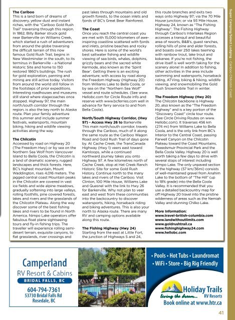
The Coast<br />
Once you reach the central coast you<br />
are met with 15,000 kilometers of aweinspiring<br />
coastline scattered with fjords<br />
and inlets, pristine beaches and rocky<br />
shores. Here is some of the world’s<br />
best saltwater fishing and wildlife<br />
viewing of sea birds, whales, dolphins,<br />
grizzly bears and the sacred white<br />
Kermode, also known as the ‘Spirit<br />
Bear’. Getting there is an exciting<br />
adventure; with access by road along<br />
the Freedom Highway (Highway 20)<br />
from Williams Lake to Bella Coola, or<br />
by sea on the “Northern Sea Wolf”<br />
vessel and route schedules. (See www.<br />
Hellobc.com for Circle Route info and<br />
reserve with www.bcferries.com well in<br />
advance for ferry service to and from<br />
Bella Coola).<br />
North/South Highway Corridor, (Hwy<br />
97) - Access Hwy 26 to Barkerville<br />
This main north/south corridor, travels<br />
through the Cariboo, much of it along<br />
the same route as the Cariboo Wagon<br />
Road and Gold Rush Trail of days gone<br />
by. At Cache Creek, the TransCanada<br />
Highway (Hwy 1) veers east toward<br />
Kamloops, while a continued<br />
northward journey takes you onto<br />
Highway 97. A few kilometres north of<br />
Cache Creek, stop at Hat Creek Ranch<br />
Historic Site for some Gold Rush<br />
History. Continue north to the many<br />
lakes and rivers of the Cariboo. Visit<br />
Clinton, 100 Mile House, Williams Lake<br />
and Quesnel with the link to Hwy 26<br />
for Barkerville. Why not plan to veer<br />
east and west from these communities<br />
into the backcountry to discover<br />
watersports, hiking, horseback riding<br />
and biking adventures. This is also your<br />
north to Alaska route. There are many<br />
RV and camping options available<br />
along this route.<br />
The Fishing Highway (Hwy 24)<br />
Starting from the east at Little Fort,<br />
the junction of Highways 5 and 24,<br />
this route branches and exits two<br />
ways onto Highway 97; via the 70 Mile<br />
House junction; or via 93 Mile House.<br />
Highway 24, known as “The Fishing<br />
Highway”. The Fishing Highway<br />
through Cariboo’s Interlakes Region<br />
accesses a tranquil and beautiful<br />
area of resorts, B&B’s, guest ranches,<br />
rolling hills of pine and alder forests,<br />
and boasts over 250 lakes teeming<br />
with rainbow trout, lake trout and<br />
kokanee. If you’re not fishing, the<br />
drive itself is well worth taking for the<br />
scenery alone! In addition to fishing,<br />
other activities in the area include<br />
swimming and watersports, horseback<br />
riding, ATVing, biking & hiking, wildlife<br />
viewing, and snowmobiling the Gold<br />
Rush Snowmobile Trail in winter.<br />
The Freedom Highway (Hwy 20)<br />
The Chilcotin backbone is Highway<br />
20, also known as the “The Freedom<br />
Highway” and is a key portion of the<br />
“Discovery Coast” circle tour route.<br />
(See Circle Driving Routes on www.<br />
Hellobc.com). It traverses 456 km<br />
(274 mi) from Williams Lake to Bella<br />
Coola, and is the only link from BC’s<br />
Interior to the Central Coast, passing<br />
Farwell Canyon on the Chilcotin<br />
Plateau toward the Coast Mountains,<br />
Tweedsmuir Provincial Park and the<br />
Bella Coola Valley. Highway 20 is well<br />
worth taking a few days to drive with<br />
several stops of interest including<br />
Nimpo Lake. The only unpaved section<br />
of the highway (57 km/36mi) consists<br />
of well-maintained gravel from Anahim<br />
Lake to the bottom of “The Hill” (up<br />
to 18% grade) into the Bella Coola<br />
Valley. It is recommended that you<br />
use a detailed backcountry map for<br />
off Highway 20 travel into the pristine<br />
wilderness of areas such as the Nemiah<br />
Valley and stunning Chilko Lake.<br />
More Information:<br />
www.travel-british-columbia.com<br />
www.landwithoutlimits.com<br />
www.goldrushtrail.ca<br />
www.fishinghighway24.com<br />
www.hellobc.com<br />
<strong>Super</strong> <strong>Camping</strong>/Select Lodging - Cariboo Chilcotin Coast<br />
• Pools • Hot Tubs • Laundromat<br />
• WiFi • Store • Big Rig Friendly<br />
604-794-7361<br />
53730 Bridal Falls Rd<br />
Rosedale, BC<br />
Book online at www.htr.ca<br />
41