

Activating Columbia Road: Reframing a Missing Link
This report was guided by Field Projects, an Urban Planning practicum at Tufts University. Our team (Aqsa Butt, Xianzheng Fang, Marah Holland, Lev McCarthy, and Megan Morrow) was partnered with LivableStreets Alliance to consolidate previous studies, recommendations, and outreach methods relating to Columbia Road. This was in effort to inform Livable Streets’ future community engagement along the corridor.
This report was guided by Field Projects, an Urban Planning practicum at Tufts University. Our team (Aqsa Butt, Xianzheng Fang, Marah Holland, Lev McCarthy, and Megan Morrow) was partnered with LivableStreets Alliance to consolidate previous studies, recommendations, and outreach methods relating to Columbia Road. This was in effort to inform Livable Streets’ future community engagement along the corridor.

Create successful ePaper yourself
Turn your PDF publications into a flip-book with our unique Google optimized e-Paper software.
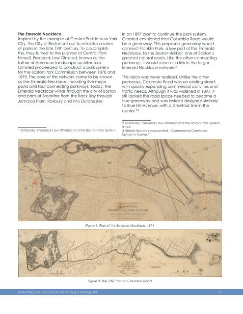
The Emerald Necklace<br />
Inspired by the example of Central Park in New York<br />
City, the City of Boston set out to establish a series<br />
of parks in the late 19th century. To accomplish<br />
this, they turned to the planner of Central Park<br />
himself, Frederick Law Olmsted, known as the<br />
father of American landscape architecture.<br />
Olmsted proceeded to construct a park system<br />
for the Boston Park Commission between 1878 and<br />
1895. The core of this network came to be known<br />
as the Emerald Necklace, including five major<br />
parks and four connecting parkways. Today, the<br />
Emerald Necklace winds through the city of Boston<br />
and parts of Brookline from the Back Bay through<br />
Jamaica Plain, Roxbury and into Dorchester. 1<br />
In an 1897 plan to continue the park system,<br />
Olmsted envisioned that <strong>Columbia</strong> <strong>Road</strong> would<br />
be a greenway. This proposed greenway would<br />
connect Franklin Park, a key part of the Emerald<br />
Necklace, to the Boston Harbor, one of Boston’s<br />
greatest natural assets. Like the other connecting<br />
parkways, it would serve as a link in the larger<br />
Emerald Necklace network. 2<br />
This vision was never realized. Unlike the other<br />
parkways, <strong>Columbia</strong> <strong>Road</strong> was an existing street,<br />
with quickly expanding commercial activities and<br />
traffic needs. Although it was widened in 1897, it<br />
still lacked the road space needed to become a<br />
true greenway and was instead designed similarly<br />
to Blue Hill Avenue, with a streetcar line in the<br />
center. 3,4<br />
1 Zaitzevsky, Frederick Law Olmsted and the Boston Park System.<br />
2 Zaitzevsky, Frederick Law Olmsted and the Boston Park System.<br />
3 Ibid.<br />
4 Historic Boston Incorporated, “Commercial Casebook:<br />
Upham’s Corner.”<br />
Figure 1: Plan of the Emerald Necklace, 1894<br />
Figure 2: The 1897 Plan of <strong>Columbia</strong> <strong>Road</strong><br />
<strong>Activating</strong> <strong>Columbia</strong> <strong>Road</strong>: <strong>Reframing</strong> a <strong>Missing</strong> <strong>Link</strong><br />
13