

Activating Columbia Road: Reframing a Missing Link
This report was guided by Field Projects, an Urban Planning practicum at Tufts University. Our team (Aqsa Butt, Xianzheng Fang, Marah Holland, Lev McCarthy, and Megan Morrow) was partnered with LivableStreets Alliance to consolidate previous studies, recommendations, and outreach methods relating to Columbia Road. This was in effort to inform Livable Streets’ future community engagement along the corridor.
This report was guided by Field Projects, an Urban Planning practicum at Tufts University. Our team (Aqsa Butt, Xianzheng Fang, Marah Holland, Lev McCarthy, and Megan Morrow) was partnered with LivableStreets Alliance to consolidate previous studies, recommendations, and outreach methods relating to Columbia Road. This was in effort to inform Livable Streets’ future community engagement along the corridor.

You also want an ePaper? Increase the reach of your titles
YUMPU automatically turns print PDFs into web optimized ePapers that Google loves.
of Blue Hill Avenue up to the Fairmount Commuter<br />
Line overpass. For the next .9 miles the median<br />
contains concrete planters. At the intersection<br />
with Massachusetts Avenue, the type changes for<br />
the last time to a narrow (about 4-foot) concrete<br />
median with two, and then eventually four, lanes<br />
of vehicular traffic up to where <strong>Columbia</strong> <strong>Road</strong><br />
terminates at the Kosciuszko Circle roundabout.<br />
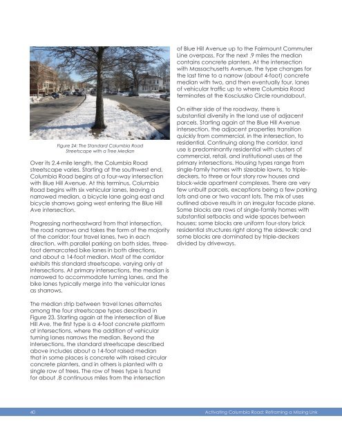
Figure 24: The Standard <strong>Columbia</strong> <strong>Road</strong><br />
Streetscape with a Tree Median<br />
Over its 2.4-mile length, the <strong>Columbia</strong> <strong>Road</strong><br />
streetscape varies. Starting at the southwest end,<br />
<strong>Columbia</strong> <strong>Road</strong> begins at a four-way intersection<br />
with Blue Hill Avenue. At this terminus, <strong>Columbia</strong><br />
<strong>Road</strong> begins with six vehicular lanes, leaving a<br />
narrowed median, a bicycle lane going east and<br />
bicycle sharrows going west entering the Blue Hill<br />
Ave intersection.<br />
Progressing northeastward from that intersection,<br />
the road narrows and takes the form of the majority<br />
of the corridor: four travel lanes, two in each<br />
direction, with parallel parking on both sides, threefoot<br />
demarcated bike lanes in both directions,<br />
and about a 14-foot median. Most of the corridor<br />
exhibits this standard streetscape, varying only at<br />
intersections. At primary intersections, the median is<br />
narrowed to accommodate turning lanes, and the<br />
bike lanes typically merge into the vehicular lanes<br />
as sharrows.<br />
On either side of the roadway, there is<br />
substantial diversity in the land use of adjacent<br />
parcels. Starting again at the Blue Hill Avenue<br />
intersection, the adjacent properties transition<br />
quickly from commercial, in the intersection, to<br />
residential. Continuing along the corridor, land<br />
use is predominantly residential with clusters of<br />
commercial, retail, and institutional uses at the<br />
primary intersections. Housing types range from<br />
single-family homes with sizeable lawns, to tripledeckers,<br />
to three or four story row houses and<br />
block-wide apartment complexes. There are very<br />
few unbuilt parcels, exceptions being a few parking<br />
lots and one or two vacant lots. The mix of uses<br />
outlined above results in an irregular facade plane.<br />
Some blocks are rows of single-family homes with<br />
substantial setbacks and wide spaces between<br />
houses; some blocks are uniform four-story brick<br />
residential structures right along the sidewalk; and<br />
some blocks are dominated by triple-deckers<br />
divided by driveways.<br />
The median strip between travel lanes alternates<br />
among the four streetscape types described in<br />
Figure 23. Starting again at the intersection of Blue<br />
Hill Ave, the first type is a 4-foot concrete platform<br />
at intersections, where the addition of vehicular<br />
turning lanes narrows the median. Beyond the<br />
intersections, the standard streetscape described<br />
above includes about a 14-foot raised median<br />
that in some places is concrete with raised circular<br />
concrete planters, and in others is planted with a<br />
single row of trees. The row of trees type is found<br />
for about .8 continuous miles from the intersection<br />
40 <strong>Activating</strong> <strong>Columbia</strong> <strong>Road</strong>: <strong>Reframing</strong> a <strong>Missing</strong> <strong>Link</strong>