EUMETSAT Annual Report 2021

Create successful ePaper yourself
Turn your PDF publications into a flip-book with our unique Google optimized e-Paper software.
<strong>EUMETSAT</strong> ANNUAL REPORT <strong>2021</strong><br />
CASE STUDY<br />
Using satellite data<br />
to benefit Romania<br />
The <strong>2021</strong> <strong>EUMETSAT</strong> Meteorological Satellite<br />
Conference was jointly hosted with the National<br />
Meteorological Administration of Romania. A<br />
highlight of the online conference was a panel<br />
discussion on how <strong>EUMETSAT</strong>’s satellite data are<br />
used to benefit Romania’s people. Here, we focus<br />
on the importance of satellite data for helping to<br />
forecast flooding in Romania.<br />
Riverine floods are one of the most destructive natural disasters<br />
worldwide and climate change is widely expected to make them<br />
more frequent and extreme in the coming decades. Yet floods can<br />
be very difficult to predict.<br />
Dr Marius Matreata, Director of Romania’s National Hydrological<br />
Forecasts Centre (NHFC), a department within the National Institute<br />
of Hydrology and Water Management, explained how the centre is<br />
using satellite data to support the delivery of short-, medium-,<br />
and long-term flood forecasting and warnings across Romania.<br />
Romania’s landscapes, culture, and economy are intertwined with<br />
rivers - the country is located almost entirely within the Danube river<br />
basin. Heavy rainfall can result in major flood events. The NHFC<br />
uses forecasting and modelling systems that integrate satellite<br />
and ground-based data to simulate and forecast hydrological<br />
processes in Romania in real time. Specialised hydrological<br />
modelling components support real-time simulation and<br />
forecasting of hydrological processes at different spatial and<br />
temporal scales, Matreata said.<br />
The centre is also a partner in regional cooperation projects, like the<br />
European Flood Awareness System, which makes use of <strong>EUMETSAT</strong><br />
Satellite Application Facilities, and the South-East Europe Flash<br />
Flood Guidance System, which is using the US National Oceanic<br />
and Atmospheric Administration’s HydroEstimator satellite-based<br />
precipitation estimates.<br />
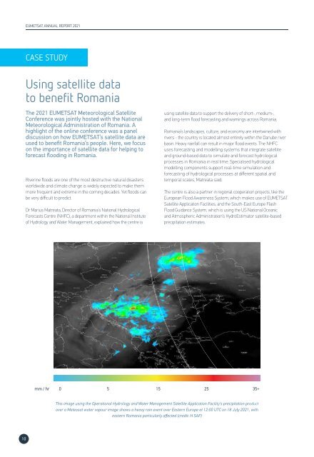
mm / hr<br />
0<br />
5 15 25<br />
35+<br />
This image using the Operational Hydrology and Water Management Satellite Application Facility’s precipitation product<br />
over a Meteosat water vapour image shows a heavy rain event over Eastern Europe at 12:00 UTC on 18 July <strong>2021</strong>, with<br />
eastern Romania particularly affected (credit: H SAF)<br />
10