EUMETSAT Annual Report 2021

Create successful ePaper yourself
Turn your PDF publications into a flip-book with our unique Google optimized e-Paper software.
<strong>EUMETSAT</strong> ANNUAL REPORT <strong>2021</strong><br />
SERVICES TO USERS<br />
NEW PRODUCTS<br />
In addition to new climate data records (see p67), seven new<br />
products were released by <strong>EUMETSAT</strong>’s Satellite Application<br />
Facility (SAF) network in <strong>2021</strong>. Another 13 SAF products were<br />
updated. Three of the new products are described below.<br />
o<br />
C<br />
60<br />
50<br />
40<br />
30<br />
20<br />
10<br />
0<br />
The Land Surface Analysis SAF released the All Sky Land Surface<br />
Temperature product on 16 March. The product provides radiative<br />
temperature over land surfaces with spatial completeness due to<br />
the combination of satellite and model data. It is derived from infrared<br />
observations (from the Meteosat SEVIRI instrument) in cloud-free<br />
situations and is obtained from the surface energy balance model<br />
in cloudy conditions. A full-disc image is produced every 30 minutes<br />
with a spatial resolution of 3-5km.<br />
The Atmospheric Composition Monitoring SAF released a sulphur<br />
dioxide product on 15 April. The product provides vertical profiles<br />
of sulphur dioxide and is based on observations from the GOME-2<br />
instrument on Metop-C. It complements operational products from<br />
Metop-B. This product includes new volcanic flags, allowing different<br />
source types of sulphur dioxide to be identified. The product is<br />
validated with reference data from satellites and ground stations.<br />
SO 2<br />
The Land Surface Analysis SAF’s All Sky Land Surface<br />
Temperature product, 1 May <strong>2021</strong> at 12:00 UTC<br />
Sulfur Dioxide<br />
total column<br />
Acquisition Time<br />
26-SEP-<strong>2021</strong> 01:52:45<br />
27-SEP-<strong>2021</strong> 00:41:21<br />
Sensor<br />
GOME-2<br />
MetOp-C<br />
Plot Range<br />
0.0 : 85.6<br />
0.4 ± 0.6<br />
-10<br />
Algorithm<br />
GDP 4.9<br />
UPAS 1.4.0<br />
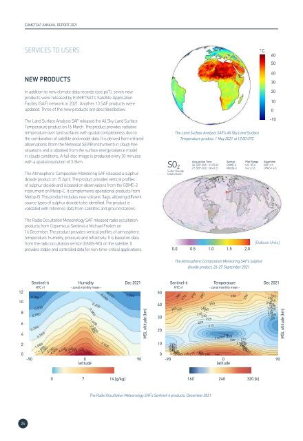
The Radio Occultation Meteorology SAF released radio occultation<br />
products from Copernicus Sentinel-6 Michael Freilich on<br />
16 December. The product provides vertical profiles of atmospheric<br />
temperature, humidity, pressure and refractivity. It is based on data<br />
from the radio occultation sensor (GNSS-RO) on the satellite. It<br />
provides stable and controlled data for non-time-critical applications.<br />
0.0<br />
0.5 1.0 1.5 2.0<br />
[Dobson Units]<br />
The Atmospheric Composition Monitoring SAF’s sulphur<br />
dioxide product, 26-27 September <strong>2021</strong><br />
Sentinel-6<br />
Humidity<br />
Dec <strong>2021</strong> Sentinel-6<br />
Temperature<br />
Dec <strong>2021</strong><br />
NTC v1<br />
- zonal monthly mean -<br />
NTC v1<br />
- zonal monthly mean -<br />
12 50<br />
10<br />
8<br />
6<br />
4<br />
2 10<br />
MSL oltitude [km]<br />
40<br />
30<br />
20<br />
MSL oltitude [km]<br />
0 0<br />
-90 0<br />
90 -90<br />
0<br />
90<br />
latitude<br />
latitude<br />
0 7 14 [g/kg] 160<br />
240<br />
320 [k]<br />
The Radio Occultation Meteorology SAF’s Sentinel-6 products, December <strong>2021</strong><br />
24