EUMETSAT Annual Report 2021

You also want an ePaper? Increase the reach of your titles
YUMPU automatically turns print PDFs into web optimized ePapers that Google loves.
<strong>EUMETSAT</strong> ANNUAL REPORT <strong>2021</strong><br />
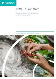
CASE STUDY<br />
In West Africa,<br />
monitoring droughts<br />
with satellites saves lives<br />
When the rains are good in the Sahel, a region of<br />
Africa just south of the Sahara stretching from<br />
northern Senegal to Sudan, baobabs bloom, millet<br />
and sorghum flourish, and harvests are fruitful.<br />
In 1968, the rain began to stop.<br />
Over the next five years, droughts caused more than half the cattle<br />
population to perish, thousands of inhabitants to flee, and more<br />
than 100,000 people to die of starvation and disease. With no<br />
reliable way to predict rainfall, or how successful harvests would be,<br />
farmers relied on traditional indicators to decide when best to plant<br />
crops. Out of this need, AGRHYMET, an organisation for drought<br />
monitoring in the Sahel, was founded in 1974. AGRHYMET collects,<br />
processes, and disseminates to its 13 member states information<br />
on food security, water resource management, desertification<br />
control, and climate change impacts.<br />
“The majority of food crises in the Sahel are still linked to drought,<br />
caused by a later start of the rainy season, shorter seasons, or dry<br />
spells,” Issa Garba, a remote sensing specialist for AGRHYMET, said.<br />
Actively monitoring for drought begins in May, when experts<br />
combine data from satellites, information from rain gauges,<br />
and hydrological and agrometeorological models to create<br />
seasonal rainfall and hydrological forecasts for July to September.<br />
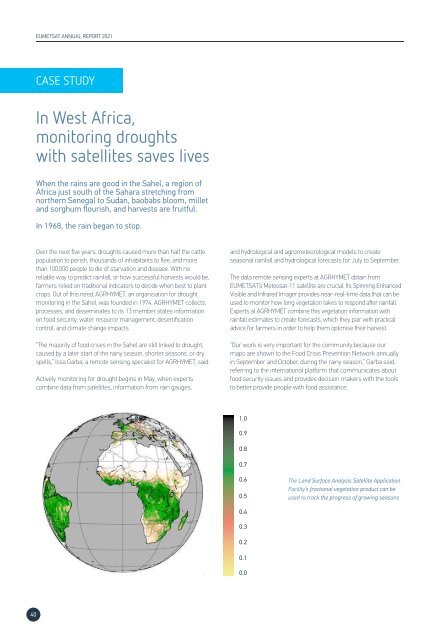
The data remote sensing experts at AGRHYMET obtain from<br />
<strong>EUMETSAT</strong>’s Meteosat-11 satellite are crucial. Its Spinning Enhanced<br />
Visible and Infrared Imager provides near-real-time data that can be<br />
used to monitor how long vegetation takes to respond after rainfall.<br />
Experts at AGRHYMET combine this vegetation information with<br />
rainfall estimates to create forecasts, which they pair with practical<br />
advice for farmers in order to help them optimise their harvest.<br />
“Our work is very important for the community because our<br />
maps are shown to the Food Crisis Prevention Network annually<br />
in September and October, during the rainy season,” Garba said,<br />
referring to the international platform that communicates about<br />
food security issues and provides decision makers with the tools<br />
to better provide people with food assistance.<br />
1.0<br />
0.9<br />
0.8<br />
0.7<br />
0.6<br />
0.5<br />
The Land Surface Analysis Satellite Application<br />
Facility’s fractional vegetation product can be<br />
used to track the progress of growing seasons<br />
0.4<br />
0.3<br />
0.2<br />
0.1<br />
0.0<br />
40