
You also want an ePaper? Increase the reach of your titles
YUMPU automatically turns print PDFs into web optimized ePapers that Google loves.
history<br />
beulah corner<br />
<strong>Rhiwbina</strong> wasn't always a bustling village. Nigel Lewis takes a look<br />
back to a time before <strong>Rhiwbina</strong> as we know it today<br />
By Nigel Lewis<br />
Many locals call the centre of<br />
<strong>Rhiwbina</strong> village Beulah Crossroads,<br />
but you don’t need to go back very<br />
far to see a very different village.<br />
If you look at the old Ordnance<br />
Survey map of 1880, you’d be hard<br />
pressed to find <strong>Rhiwbina</strong>. In fact,<br />
back then, it had a totally different<br />
name, and there was no village.<br />
The next OS map, dated 1900, is<br />
little different. It’s only when you<br />
look at the OS map for 1920 that<br />
you’d see a recognisable <strong>Rhiwbina</strong><br />
village.<br />
The earliest photographs only<br />
date from c.1900, so there’s no help<br />
there. The best source for early<br />
information is the old Parish Tithe<br />
34<br />
Map. This is dated 1840, and we’re<br />
really fortunate that this map still<br />
exists.<br />
The Tithe Map coincides with<br />
the first meaningful census, and<br />
between them, you get a pretty<br />
good idea of how many (actually<br />
how few) folk were living in the<br />
area. There were lots of farms with<br />
individual fields, a few cottages,<br />
some meandering tracks, and an<br />
old stream. And there were just a<br />
few grander houses.<br />
At the start of this new season, I<br />
thought it might be fun to look at<br />
this tiny corner of the parish and to<br />
discover some of the things that<br />
have been lost in time.<br />
The Tithe Map lists all of the<br />
landowners (nearly all absentee<br />
landlords with huge estates), it lists<br />
the tenants of the various farms<br />
and cottages, and wonderfully the<br />
names of so many of the fields. In<br />
addition, the census lists everyone<br />
living in each place (husbands,<br />
wives, children and even visitors); it<br />
is possible to see how the two link<br />
up.<br />
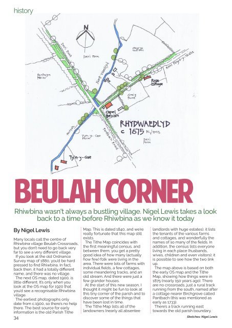
The map above is based on both<br />
the early OS map and the Tithe<br />
Map, showing how things were in<br />
1875 (nearly 150 years ago). There<br />
are no crossroads, just a rural track<br />
running from the south, named after<br />
a cottage nearer Birchgrove called<br />
Pantbach (this was mentioned as<br />
early as 1733).<br />
There’s a track running east<br />
towards the old parish boundary.<br />
Sketches: Nigel Lewis