
Create successful ePaper yourself
Turn your PDF publications into a flip-book with our unique Google optimized e-Paper software.
This would later become Beulah<br />
Road, but back then it was called<br />
Heol Rhyd-y-Walla. Remember,<br />
until quite late into the 19th century,<br />
nearly the whole of the parish was<br />
Welsh speaking.<br />
And there was a narrow farm track<br />
running northwards, towards Deri<br />
Farm. Nothing to the west, just<br />
fields.<br />
No <strong>Rhiwbina</strong> back then. The area<br />
was named Rhydwaedlyd after the<br />
stream (Nant Waedlyd, the bloody<br />
brook!), Rhydwaedlyd meaning the<br />
ford on the stream. In all probability,<br />
there was an ancient fording-place<br />
here, where people and animals<br />
could safely cross. There were even<br />
earlier names - Rhyd-y-Walla and<br />
various other derivatives.<br />
Anyway, back to the sketch map.<br />
By 1840 and the Tithe Map, the<br />
ancient ford had gone and been<br />
replaced by a simple humpback<br />
bridge with the stream running<br />
diagonally, but by 1875 and this<br />
map, the stream had been locally<br />
diverted and a flatter bridge<br />
provided.<br />
There were three farms that<br />
converged at ‘the crossroads’;<br />
the nearest was Ty’n-y-Cae to the<br />
southwest, Pentwyn Uchaf to the<br />
northwest, and many of the fields to<br />
the east belonged to the Deri Farm.<br />
The fields shown on the southeast<br />
corner were an isolated pocket of<br />
Graig Farm. Incredibly, the Graig<br />
farmhouse still stands today, visible<br />
from the motorway as you leave<br />
the junction at Coryton towards<br />
Newport.<br />
There were at least 6-10 more<br />
farms in the immediate area, but<br />
perhaps we could look at them<br />
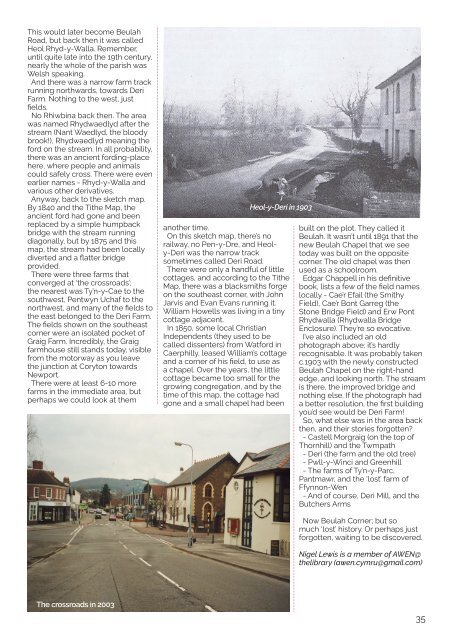
Heol-y-Deri in 1903<br />
another time.<br />
On this sketch map, there’s no<br />
railway, no Pen-y-Dre, and Heoly-Deri<br />
was the narrow track<br />
sometimes called Deri Road.<br />
There were only a handful of little<br />
cottages, and according to the Tithe<br />
Map, there was a blacksmiths forge<br />
on the southeast corner, with John<br />
Jarvis and Evan Evans running it.<br />
William Howells was living in a tiny<br />
cottage adjacent.<br />
In 1850, some local Christian<br />
Independents (they used to be<br />
called dissenters) from Watford in<br />
Caerphilly, leased William’s cottage<br />
and a corner of his field, to use as<br />
a chapel. Over the years, the little<br />
cottage became too small for the<br />
growing congregation, and by the<br />
time of this map, the cottage had<br />
gone and a small chapel had been<br />
built on the plot. They called it<br />
Beulah. It wasn’t until 1891 that the<br />
new Beulah Chapel that we see<br />
today was built on the opposite<br />
corner. The old chapel was then<br />
used as a schoolroom.<br />
Edgar Chappell in his definitive<br />
book, lists a few of the field names<br />
locally - Cae’r Efail (the Smithy<br />
Field), Cae’r Bont Garreg (the<br />
Stone Bridge Field) and Erw Pont<br />
Rhydwalla (Rhydwalla Bridge<br />
Enclosure). They’re so evocative.<br />
I’ve also included an old<br />
photograph above; it’s hardly<br />
recognisable. It was probably taken<br />
c.1903 with the newly constructed<br />
Beulah Chapel on the right-hand<br />
edge, and looking north. The stream<br />
is there, the improved bridge and<br />
nothing else. If the photograph had<br />
a better resolution, the first building<br />
you’d see would be Deri Farm!<br />
So, what else was in the area back<br />
then, and their stories forgotten?<br />
- Castell Morgraig (on the top of<br />
Thornhill) and the Twmpath<br />
- Deri (the farm and the old tree)<br />
- Pwll-y-Winci and Greenhill<br />
- The farms of Ty’n-y-Parc,<br />
Pantmawr, and the ‘lost’ farm of<br />
Ffynnon-Wen<br />
- And of course, Deri Mill, and the<br />
Butchers Arms<br />
Now Beulah Corner; but so<br />
much ‘lost’ history. Or perhaps just<br />
forgotten, waiting to be discovered.<br />
Nigel Lewis is a member of AWEN@<br />
thelibrary (awen.cymru@gmail.com)<br />
The crossroads in 2003<br />
35