

The Soils of The Regional Municipality of Ottawa=Carleton
The Soils of The Regional Municipality of Ottawa=Carleton
The Soils of The Regional Municipality of Ottawa=Carleton

Create successful ePaper yourself
Turn your PDF publications into a flip-book with our unique Google optimized e-Paper software.
their agricultural use . <strong>The</strong> dominantly occurring textures <strong>of</strong><br />
those encountered are shown in the legend .<br />
SoilLandscapeUnit A subdivision <strong>of</strong>the soil association representing<br />
a landscape area having specific proportions <strong>of</strong>identified<br />
drainage components and surface slopes which occur<br />
within a defined range and in a set pattern . On the map, this<br />
unit composes part <strong>of</strong>the map unit symbol shown for a delineated<br />
area.<br />
Land 1 rpe Unit A subdivision <strong>of</strong> the land type representing a<br />
land area having specific soil or land conditions which serve to<br />
distinguish the area from others which may be included in the<br />
land type . For example, the Rockland land type has primarily<br />
been subdivided into land type units on the basis <strong>of</strong> different<br />
types <strong>of</strong>bedrock which occur.<br />
Soil Drainage <strong>The</strong> rapidity with which water is removed from<br />
the soilin relation to supply. Supply or additions <strong>of</strong>water occur<br />
inthe form <strong>of</strong> precipitation, groundwater flow, or surface run<strong>of</strong>f<br />
water from surrounding soils. Removal <strong>of</strong> water relates to a<br />
number <strong>of</strong> factors including texture, structure, landscape position,<br />
and length and gradient <strong>of</strong> slope .<br />
Soil drainage was determined using the drainage classification<br />
guidelines outlined inthe Canadian System <strong>of</strong> Soil Classification<br />
(22) . In this survey, drainage classes defined in that<br />
system were grouped resulting in five soil drainage descriptions<br />
. <strong>The</strong>se descriptions are as follows : (1) Excessive - very<br />
rapidly or rapidly drained ; (2) Good-well-drained or moderately<br />
well-drained ; (3) Imperfect - imperfectly drained ; (4)<br />
Poor - poorly drained ; and (5) Very Poor - very poorly<br />
drained . Definitions <strong>of</strong> the seven soil drainage classes which<br />
make up these groupings are given in Appendix 1 .<br />
Dominant and Significant <strong>The</strong>se are terms which refer to<br />
either the relative proportions <strong>of</strong> land areas which compose a<br />
map delineation represented by acompound map unit symbol,<br />
or the relative proportions <strong>of</strong> soil drainage components composing<br />
a soil landscape unit used to define a particular land<br />
area . Dominantmeans that more than 4001o <strong>of</strong> themap delineation<br />
consists <strong>of</strong> that type <strong>of</strong> land area, or, more than 40 01o <strong>of</strong><br />
the soil landscape unit and therefore land area is composed <strong>of</strong><br />
that drainage state. Significant means that more than20% but<br />
less than 40% consists <strong>of</strong> the land area or drainage state indicated<br />
. Land areas or drainage conditions occupying 20 010 or<br />
U<br />
0<br />
(dark brown)<br />
(dark yellowish brown)<br />
(light yellowish brown)<br />
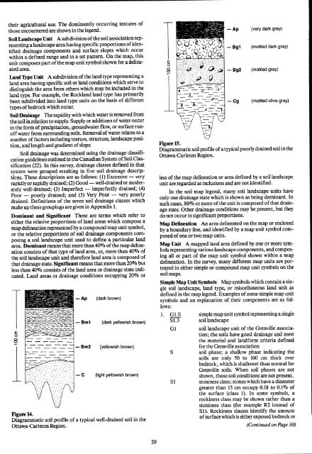
Figure 14 .<br />
Diagrammatic soil pr<strong>of</strong>ile <strong>of</strong> a typical well-drained soil in the<br />
Ottawa-Carleton Region .<br />
E<br />
U<br />
ô<br />
Ap<br />
- Bg1<br />
(very dark gray)<br />
(mottled dark gray)<br />
-Bg2 (mottled gray)<br />
(mottled olive gray)<br />
Figure 15 .<br />
Diagrammatic soil pr<strong>of</strong>ile <strong>of</strong>atypicalpoorly drained soil in the<br />
Ottawa-Carleton Region .<br />
less <strong>of</strong>the map delineation or area defined by a soil landscape<br />
unit are regardedas inclusions and are not identified .<br />
In the soil map legend, many soil landscape units have<br />
only one drainage state which is shown as being dominant . In<br />
such cases, 80 010 or more <strong>of</strong>the unit is composed <strong>of</strong>that drain<br />
age state. Other drainage conditions may be present, but they<br />
do not occur in significant proportions .<br />
Map Delineation An area delineated on the map or enclosed<br />
by a boundary line, and identified by a map unit symbol composed<br />
<strong>of</strong>one ortwo map units .<br />
Map Unit A mapped land area defined by one or more symbols<br />
representing various landscape components, and composing<br />
all or part <strong>of</strong> the map unit symbol shown within a map<br />
delineation. In the survey, many different map units are portrayed<br />
in either simple or compound map unit symbols on the<br />
soil maps .<br />
Simple Map Unit Symbols Map symbols which contain a single<br />
soil landscape, land type, or miscellaneous land unit as<br />
defined in the map legend . Examples <strong>of</strong> some simple map unit<br />
symbols and an explanation <strong>of</strong> their components are as follows<br />
:<br />
1 . G1 .S simple map unit symbol representing a single<br />
S1 .3 soil landscape<br />
GI soil landscape unit <strong>of</strong> the Grenville association<br />
; the soils have good drainage and meet<br />
the material and landform criteria defined<br />
for the Grenville association<br />
S soil phase ; a shallow phase indicating the<br />
soils are only 50 to 100 cm thick over<br />
bedrock, which is shallower than normal for<br />
Grenville soils. When soil phases are not<br />
shown, those soil conditions are not present .<br />
St stoniness class ; stones whichhave a diameter<br />
greater than 15 cm occupy 0 .01 to 0.1% <strong>of</strong><br />
the surface (class 1) . In some symbols, a<br />
rockiness class may be shown rather than a<br />
stoniness class (for example R2 instead <strong>of</strong><br />
S1) . Rockiness classes identify the amount<br />
<strong>of</strong> surface which is either exposed bedrock or<br />
(Continued on Page 30)


