

The Soils of The Regional Municipality of Ottawa=Carleton
The Soils of The Regional Municipality of Ottawa=Carleton
The Soils of The Regional Municipality of Ottawa=Carleton

Create successful ePaper yourself
Turn your PDF publications into a flip-book with our unique Google optimized e-Paper software.
In some soils, significant layers <strong>of</strong>coarser textured materials<br />
occur which have clay loam, silty clay loam, silt loam, or<br />
loam textures . Thickness <strong>of</strong> the layers is highly variable. Occa<br />
sionally, some soil materials also gradeinto heavy clay near the<br />
bottom <strong>of</strong>the control section .<br />
Four soil phases were recognized, with each being very<br />
limited inextent . An organic phase was recognized in which 15<br />
to 40 cm <strong>of</strong> organic material occurred on the surface <strong>of</strong> some<br />
very poorly drained soils . A coarse phase was applied to<br />
Dalhousie soils which had 15 to 40 cm <strong>of</strong> sandy material at the<br />
surface. Occasionally, a shallow phase was necessary where<br />
bedrock occurred at depths between 50 and 100 cm, and a<br />
rockiness phase was applied to some Dalhousie landscapes<br />
with intermittent rock outcrops.<br />
Soil Moisture Characteristics More than 90% <strong>of</strong> the<br />
Dalhousie soils mapped in the survey area are poorly drained .<br />
<strong>The</strong>yoccur on level or nearly levellandscapes having slopes less<br />
than 2% . Occasionally, very poorly drained soils occur in<br />
depressional areas . In both soils, drainage is restricted due to<br />
high water tables resulting from groundwater discharge and<br />
surface water run<strong>of</strong>f from adjacent areas . Imperfectly drained<br />
soils also are found in the survey area but are quite limited in<br />
extent . <strong>The</strong>y occur on the mid to upper slopes <strong>of</strong> very gently<br />
sloping landscapes . Slopes range from 2 to 5% .<br />
Dalhousie soils have generally medium permeability and<br />
highmoisture holding capacity. In some soils, permeability has<br />
been significantly reduced due to compaction by heavy<br />
machinery associated with monocultural tillage practices such<br />
as continuous corn cropping . Surface run<strong>of</strong>f on Dalhousie<br />
soils is slow to moderate.<br />
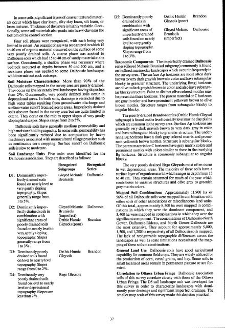
Soil Landscape Units Five units were identified for the<br />
Dalhousie association . <strong>The</strong>y are described as follows :<br />
Recognized Recognized<br />
Subgroups Series<br />
D 1 : Dominantly imper- Gleyed Melanie Dalhousie<br />
fectly drained soils Brunisols<br />
found on nearly level to<br />
very gently sloping<br />
topography. Slopes<br />
generally range from<br />
I to 5 01o .<br />
D2 : Dominantly imper- Gleyed Melanie Dalhousie<br />
fectly drained soils in Brunisols<br />
combination with (imperfect)<br />
significant areas <strong>of</strong> Orthic Humic Brandon<br />
poorlydrained soils Gleysols (poor)<br />
found on nearly level to<br />
very gently sloping<br />
topography. Slopes<br />
generally range from<br />
Ito3% .<br />
D3 : Dominantlypoorly Orthic Humic Brandon<br />
drained soils found Gleysols<br />
on level to nearly level<br />
topography. Slopes<br />
range from0 to 2% .<br />
D4 : Dominantlyvery Rego Gleysols<br />
poorly drained soils<br />
found on level to nearly<br />
level or depressional<br />
topography. Slopes are<br />
lessthan 2% .<br />
D5 : Dominantly poorly Orthic Humic Brandon<br />
drained soils in Gleysols (poor)<br />
combination with<br />
significant areas <strong>of</strong> Gleyed Melanie Dalhousie<br />
imperfectly drained Brunisols<br />
soils found on nearly (imperfect)<br />
levelto very gently<br />
sloping topography.<br />
Slopes range from<br />
Ito3olo .<br />
Taxonomic Components <strong>The</strong> imperfectly drained Dalhousie<br />
series (Gleyed Melanie Brunisol subgroup) commonly is found<br />
on inclinedmarine claylandscapes which occur infrequently in<br />
the survey area. <strong>The</strong> surface Ap horizons are most <strong>of</strong>ten dark<br />
brown to very dark grayish brown in color andhave subangular<br />
blocky to granular structure. <strong>The</strong> underlying Bmgj horizons<br />
are olive to dark grayish brown in color and also have subangular<br />
blocky structure. Faint to distinct olive colored mottles may<br />
be present inthese horizons . <strong>The</strong> parent material orC horizons<br />
are gray in color and have prominent yellowish brown to olive<br />
brown mottles . Structure ranges from subangular blocky to<br />
angular blocky.<br />
<strong>The</strong> poorly drained Brandon series (Orthic Humic Gleysol<br />
subgroup) is found on the level to nearly level marine clay plains<br />
which are common in the survey area . Surface Ap horizons are<br />
generally very dark grayish brown to very dark gray in color<br />
and have subangular blocky to granular structure. <strong>The</strong> underlying<br />
Bg horizons have a dark gray colored matrix and prominent<br />
yellowish brown mottles . Structure is subangular blocky.<br />
<strong>The</strong> parent material or C horizons have gray matrix colors and<br />
prominent mottles with colors similar to those in the overlying<br />
Bg horizons . Structure is commonly subangular to angular<br />
blocky.<br />
<strong>The</strong> very poorly drained Rego Gleysols most <strong>of</strong>ten occur<br />
in wet depressional areas . <strong>The</strong> majority <strong>of</strong> these soils have a<br />
surface layer <strong>of</strong> organic materialwhich ranges in depth from 15<br />
to 40 cm. <strong>The</strong>y remain saturated for much <strong>of</strong> the year which<br />
contributes to massive structures and olive gray to greenish<br />
gray matrix colors .<br />
Mapped Soil Combinations Approximately 11,900 ha or<br />
56% <strong>of</strong> all Dalhousie soils were mapped in combination with<br />
either soils <strong>of</strong> other associations or miscellaneous land units .<br />
Of this total, approximately 8,500 ha were mapped in combinations<br />
in which they were the dominant component, and<br />
3,400 ha were mapped in combinations in which they were the<br />
significant component . <strong>The</strong> combinations <strong>of</strong>Dalhousie-North<br />
Gower, Dalhousie-Rideau, and North Gower-Dalhousie are<br />
the most extensive. <strong>The</strong>y account for approximately 5,000,<br />
1,500, and 1,200 ha respectively <strong>of</strong> all Dalhousie soils mapped .<br />
<strong>The</strong> lack <strong>of</strong> recognizable topographic differences across the<br />
landscapes as well as scale limitations necessitated the mapping<br />
<strong>of</strong>these soils in combinations .<br />
General Land Use Dalhousie soils have good agricultural<br />
capability for common field crops . <strong>The</strong>y are widely utilized for<br />
the production <strong>of</strong> corn, cereal grains, and hay. Some soils in<br />
small localized areas remain in permanent pasture or are forested<br />
.<br />
Correlation to Ottawa Urban Fringe Dalhousie association<br />
soils <strong>of</strong> this survey correlate closely with those <strong>of</strong> the Ottawa<br />
Urban Fringe . <strong>The</strong> DS soil landscape unit was developed for<br />
this survey in order to characterize landscapes with dominantly<br />
poor drainage and significant imperfect drainage. <strong>The</strong><br />
smaller map scale <strong>of</strong> this survey made this decision practical .


