FELDKIRCH - Bodensee-Vorarlberg Tourismus
FELDKIRCH - Bodensee-Vorarlberg Tourismus
FELDKIRCH - Bodensee-Vorarlberg Tourismus

You also want an ePaper? Increase the reach of your titles
YUMPU automatically turns print PDFs into web optimized ePapers that Google loves.
Schellenberg (730m)<br />
Walk up the castle path (Feldkirch-Tosters) to the<br />
ruins of Tosters Castle. Take the main path back<br />
to St. Corneli Church with its 1000 yearold Yew<br />
tree. Take the Rüttele path to Schellenbergstrasse<br />
and continue on to Hubstrasse; take Werdenbergstrasse<br />
to the old St. Michael’s Church in Tisis,<br />
then via Feldweg to Rheinbergerstrasse. Turn left<br />
and continue down Hohlegasse to the Kapf and<br />
over the large bridge on the left into the town<br />
centre of the city. Takes about 3 hours.<br />
Hiking maps are available at the Tourist Office,<br />
Feldkirch.<br />
11<br />
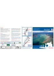
Cycling<br />
Feldkirch is a town at the<br />
crossroads of three countries,<br />
Austria,Switzerland and<br />
Liechtenstein. Connecting these<br />
countries there are several cycle<br />
paths in the Rhine Valley and the<br />
Walgau Valley which enable keen<br />
cyclists and family groups to<br />
explore the surroundings. Feldkirch<br />
is also an excellent starting point<br />
for mountain biking (Älpele, Gamp,<br />
Alpwegkopf,Hohe Kugel, Hoher<br />
Kasten, Pfälzer Hütte etc.) The<br />
mountain ranges east and west of<br />
the Rhine valley and the Walgau<br />
can be reached via short, flat<br />
approaches on the cycle paths<br />
(10- 20 km.) Take advantage of the<br />
regional railway service whereby<br />
bikes can be transported without a<br />
problem, and you will be able to go<br />
on extensive mountain bike trips in<br />
the high alpine areas of Montafon<br />
and Arlberg. Cycling map available<br />
at the Feldkirch tourist office.<br />
Cycle hire, see page 35.