antiquarian bookseller - Peter Harrington
antiquarian bookseller - Peter Harrington
antiquarian bookseller - Peter Harrington

You also want an ePaper? Increase the reach of your titles
YUMPU automatically turns print PDFs into web optimized ePapers that Google loves.
<strong>Peter</strong> <strong>Harrington</strong> Antiquarian Bookseller<br />
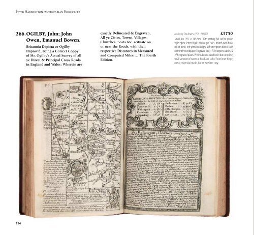
266.OGILBY, John; John<br />
Owen, Emanuel Bowen.<br />
134<br />
Britannia Depicta or Ogilby<br />
Improv’d; Being a Correct Coppy<br />
of Mr. Ogilby’s Actual Survey of all<br />
ye Direct & Principal Cross Roads<br />
in England and Wales: Wherein are<br />
exactly Delineated & Engraven,<br />
All ye Cities, Towns, Villages,<br />
Churches, Seats &c. scituate on<br />
or near the Roads, with their<br />
respective Distances in Measured<br />
and Computed Miles … The fourth<br />
Edition.<br />
London, by Tho. Bowles, 1751 [31652] £1750<br />
Small 4to (195 × 138 mm). 19th-century full calf to period<br />
style, spine lettered gilt, double gilt rules, boards with floral<br />
roll in blind, red sprinkled edges. Gift inscription dated 1884<br />
on front free endpaper. Engraved title, 4 ff. letterpress tables, &<br />
273 engraved plates. Prelims bound out of order but complete,<br />
small amount of worm at head and tail of front inner hinge,<br />
one or two trivial marks, but an excellent copy.<br />
Fourth Edition of this popular reduced version of John<br />
Ogilby’s 1675 road atlas augmented by fifty-four county<br />
maps and historical notes by John Owen, the whole<br />
engraved on 273 strip-maps by Emanuel Bowen. First<br />
published thus in 1720, this fourth edition formed the<br />
basis of several reissues over the next forty years. “Ogilby<br />
made the first survey of the roads of England and Wales,<br />
and is probably best known on this account … Sir<br />
John Fordham … says [the survey] ‘is of particular and<br />
historical importance, as it displaced the old British mile<br />
of 2,428 yards, and substituted it for the statute mile of<br />
1,760 yards, thus effecting a revolution in customary<br />
measurements’” (Chubb, p. 444).<br />
RARE HAND-COLOURED<br />
LITHOGRAPHS OF ALPINE<br />
SCENERY<br />
267.[PEZOLT, Georg]<br />
Album vom Salzburger Alpenlande.<br />
Wildbad Gastein: J. Schoen, in Commission bei H. Abel in Salzburg, [c.<br />
1850] [18946] £3500<br />
Oblong 8vo (162 × 220 mm). Contemporary brown moroccograin<br />
lacquered cloth, covers stamped in blind with thick-andthin<br />
outer border, front cover with the word “Album” stamped<br />
in blind, brown cloth backstrip. Chromolithograph title<br />
Catalogue 57: Travel Section 6: Europe, including Constantinople<br />
and 30 hand-coloured lithographic views, each with green<br />
tissue guard. A couple of tissue guards creased, occasional<br />
light foxing to margins, one plate with two small marks, an<br />
excellent copy.<br />
FIRST AND ONLY EDITION. An extremely rare item.<br />
We cannot locate any copy in institutional holdings<br />
worldwide; only COPAC has anything close with an<br />
undated folio “Album vom Salzburger-Alpenlande (nach<br />
d. Natur gez. v. Gg. Pezolt. Lith. v. Leop. Rottmann.)” in the<br />
National Library of Scotland. The plates, showing Alpine<br />
scenery around Salzburg, including Wildbad Gastein and<br />
Berchtesgarten, are signed “Gez. v. G. Pezolt / Stahlstich<br />
u. Druch v. Serz & Cie. in Nürnberg”. The firm of Serz & Cie.<br />
was founded in 1848.<br />
135