antiquarian bookseller - Peter Harrington
antiquarian bookseller - Peter Harrington
antiquarian bookseller - Peter Harrington

You also want an ePaper? Increase the reach of your titles
YUMPU automatically turns print PDFs into web optimized ePapers that Google loves.
<strong>Peter</strong> <strong>Harrington</strong> Antiquarian Bookseller<br />
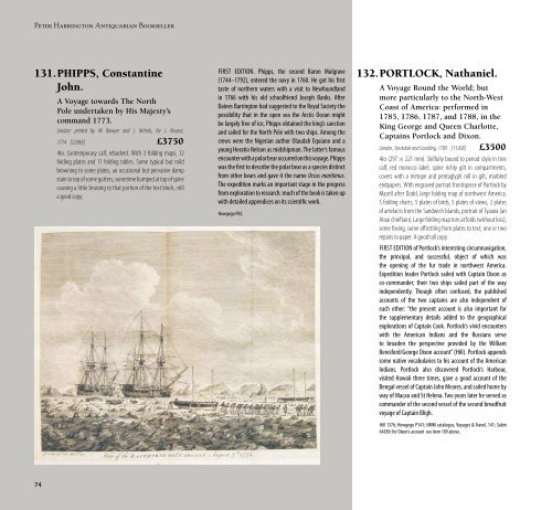
131.PHIPPS, Constantine<br />
John.<br />
A Voyage towards The North<br />
Pole undertaken by His Majesty’s<br />
command 1773.<br />
London: printed by W. Bowyer and J. Nichols, for J. Nourse,<br />
1774 [22966] £3750<br />
4to. Contemporary calf, rebacked. With 3 folding maps, 12<br />
folding plates and 11 folding tables. Some typical but mild<br />
browning to some plates, an occasional but pervasive damp<br />
stain to top of some gutters, sometime bumped at top of spine<br />
causing a little bruising to that portion of the text block, still<br />
a good copy.<br />
FIRST EDITION. Phipps, the second Baron Mulgrave<br />
(1744–1792), entered the navy in 1760. He got his first<br />
taste of northern waters with a visit to Newfoundland<br />
in 1766 with his old schoolfriend Joseph Banks. After<br />
Daines Barrington had suggested to the Royal Society the<br />
possibility that in the open sea the Arctic Ocean might<br />
be largely free of ice, Phipps obtained the king’s sanction<br />
and sailed for the North Pole with two ships. Among the<br />
crews were the Nigerian author Olaudah Equiano and a<br />
young Horatio Nelson as midshipman. The latter’s famous<br />
encounter with a polar bear occurred on this voyage. Phipps<br />
was the first to describe the polar bear as a species distinct<br />
from other bears and gave it the name Ursus maritimus.<br />
The expedition marks an important stage in the progress<br />
from exploration to research: much of the book is taken up<br />
with detailed appendices on its scientific work.<br />
Howgego P82.<br />
132.PORTLOCK, Nathaniel.<br />
A Voyage Round the World; but<br />
more particularly to the North-West<br />
Coast of America: performed in<br />
1785, 1786, 1787, and 1788, in the<br />
King George and Queen Charlotte,<br />
Captains Portlock and Dixon.<br />
London, Stockdale and Goulding, 1789 [11268] £3500<br />
4to (297 × 221 mm). Skilfully bound to period style in tree<br />
calf, red morocco label, spine richly gilt in compartments,<br />
covers with a metope and pentaglyph roll in gilt, marbled<br />
endpapers. With engraved portrait frontispiece of Portlock by<br />
Mazell after Dodd, large folding map of northwest America,<br />
5 folding charts, 5 plates of birds, 5 plates of views, 2 plates<br />
of artefacts from the Sandwich Islands, portrait of Tyaana (an<br />
Atoui chieftain). Large folding map torn at folds (without loss),<br />
some foxing, some offsetting from plates to text, one or two<br />
repairs to paper. A good tall copy.<br />
FIRST EDITION of Portlock’s interesting circumnavigation,<br />
the principal, and successful, object of which was<br />
the opening of the fur trade in northwest America.<br />
Expedition leader Portlock sailed with Captain Dixon as<br />
co-commander; their two ships sailed part of the way<br />
independently. Though often confused, the published<br />
accounts of the two captains are also independent of<br />
each other: “the present account is also important for<br />
the supplementary details added to the geographical<br />
explorations of Captain Cook. Portlock’s vivid encounters<br />
with the American Indians and the Russians serve<br />
to broaden the perspective provided by the William<br />
Beresford/George Dixon account” (Hill). Portlock appends<br />
some native vocabularies to his account of the American<br />
Indians. Portlock also discovered Portlock’s Harbour,<br />
visited Hawaii three times, gave a good account of the<br />
Bengal vessel of Captain John Meares, and sailed home by<br />
way of Macao and St Helena. Two years later he served as<br />
commander of the second vessel of the second breadfruit<br />
voyage of Captain Bligh.<br />
Hill 1376; Howgego P141; NMM catalogue, Voyages & Travel, 141; Sabin<br />
64389; for Dixon’s account see item 109 above.<br />
133.POWERS, Mabel<br />
(Yehsennohwehs).<br />
The Indian as Peacemaker.<br />
Fleming H. Revell Company, New York, 1932 [36954] £750<br />
224pp. Frontispiece and five other plates. Small inked<br />
ownership inscription to the upper board, otherwise very<br />
good in the original pale grey cloth in slightly worn dustjacket,<br />
sunned at the spine.<br />
Lengthy inscription to Mrs. Cora Shippes Anthony to<br />
the front free endpaper dated “Moon of Lengthening<br />
Days” 1936. Envelope mounted on the front pastedown<br />
containing two small flyers for the book, Mrs. Anthony’s<br />
business card (she was a piano instructor in Williamsport,<br />
PA), and a typed postcard signed by Powers apologising<br />
for the delay in mailing off this copy of the book, and<br />
enquiring about the possibilities of speaking engagements<br />
in the Williamsport area.<br />
THE FIRST GENERAL<br />
DESCRIPTION OF FLORIDA IN<br />
ENGLISH<br />
134.ROBERTS, William.<br />
An Account of the First Discovery,<br />
and Natural History of Florida. With<br />
a Particular Detail of the Several<br />
Expeditions and Descents made on<br />
that Coast. Collected from the Best<br />
Authorities by … Illustrated by a<br />
General Map, and some Particular<br />
Plans, together with a Geographical<br />
Description of that Country by T.<br />
Jeffreys, Geographer to His Majesty.<br />
London, T. Jeffreys, 1763 [39498] £12,500<br />
4to. (270 × 218mm). Well-executed recent Cambridge<br />
Catalogue 57: Travel Section 3: The Americas, Greenland and the Arctic<br />
panelled calf, red morocco label, spine gilt in compartments<br />
Folding frontispiece map of Florida, colony coloured yellow in<br />
outline, folding plans of Pensacola, Bay of St. Joseph’s, Bahia<br />
del Espiritu Santu, St. Augustin, the Island and Bay of Mobile,<br />
and an engraved view of Pensacola. Light browning, scattered<br />
foxing, but overall a very good copy.<br />
FIRST EDITION. After belonging alternately to France and<br />
Spain, Florida was finally ceded to England in exchange<br />
for Cuba in the Treaty of Paris which concluded the Seven<br />
Years’ War. Roberts published in response to the newly<br />
awakened interest in the area and makes claims for the<br />
“English as the first discoverers of this continent” in 1496,<br />
crediting Sebastian Cabot in the service of Henry VII.<br />
Perhaps more accurate and germane are the observations,<br />
accompanied by the plan of Mobile, of Captain Thomas<br />
Robinson who visited the colony in 1754. “The first general<br />
description of the two new British colonies [Florida and<br />
Louisiana East of the Mississippi] and adjacent areas”<br />
(Servies).<br />
Howes R348; Sabin 71926; Servies 436.<br />
135.ROOSEVELT, Theodore.<br />
Through the Brazilian Wilderness.<br />
Charles Scribner’s Sons, New York, 1914 [39522] £3850<br />
8vo. Publisher’s brown cloth, title gilt to spine and upper board,<br />
top edge gilt, others untrimmed. Photogravure frontispiece<br />
and 48 half-tone plates, one folding and 2 full-page maps.<br />
Endpapers browned, a little light marginal browning, else<br />
very good.<br />
FIRST EDITION, PRESENTATION COPY, inscribed, “To Dr.<br />
Bellinger with the best wishes of Thoedore Roosevelt,<br />
Dec. 6th 1917” on the front free endpaper. The account<br />
of Roosevelt’s “zoogeographic reconnaissance” with the<br />
Brazilian explorer Rondon to discover if the Rio da Dúvida<br />
(“River of Doubt”), flowed into the Amazon. Traversing<br />
some of the most dangerous territory of Amazonia, the<br />
party was successful and the river was renamed Rio<br />
Roosevelt, sometimes Rio Teodoro, in his honour.