Water, Land and People - Goulburn Broken Catchment ...
Water, Land and People - Goulburn Broken Catchment ...
Water, Land and People - Goulburn Broken Catchment ...

Create successful ePaper yourself
Turn your PDF publications into a flip-book with our unique Google optimized e-Paper software.
PROGRAM REPORTS<br />
20<br />
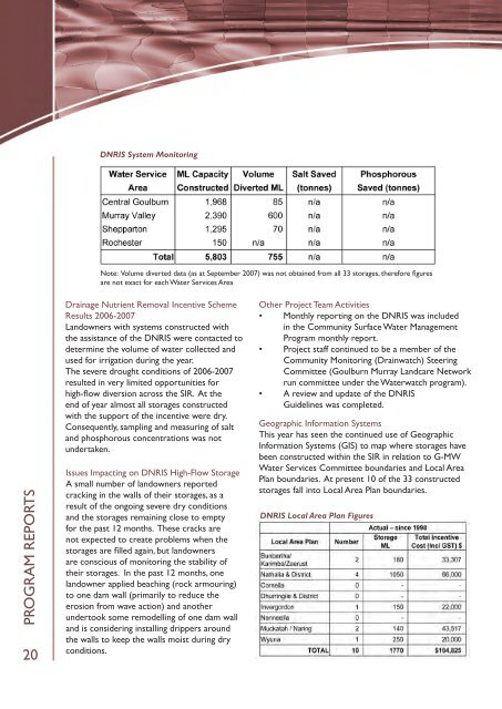
DNRIS System Monitoring<br />
Note: Volume diverted data (as at September 2007) was not obtained from all 33 storages, therefore figures<br />
are not exact for each <strong>Water</strong> Services Area<br />
Drainage Nutrient Removal Incentive Scheme<br />
Results 2006-2007<br />
<strong>L<strong>and</strong></strong>owners with systems constructed with<br />
the assistance of the DNRIS were contacted to<br />
determine the volume of water collected <strong>and</strong><br />
used for irrigation during the year.<br />
The severe drought conditions of 2006-2007<br />
resulted in very limited opportunities for<br />
high-flow diversion across the SIR. At the<br />
end of year almost all storages constructed<br />
with the support of the incentive were dry.<br />
Consequently, sampling <strong>and</strong> measuring of salt<br />
<strong>and</strong> phosphorous concentrations was not<br />
undertaken.<br />
Issues Impacting on DNRIS High-Flow Storage<br />
A small number of l<strong>and</strong>owners reported<br />
cracking in the walls of their storages, as a<br />
result of the ongoing severe dry conditions<br />
<strong>and</strong> the storages remaining close to empty<br />
for the past 12 months. These cracks are<br />
not expected to create problems when the<br />
storages are filled again, but l<strong>and</strong>owners<br />
are conscious of monitoring the stability of<br />
their storages. In the past 12 months, one<br />
l<strong>and</strong>owner applied beaching (rock armouring)<br />
to one dam wall (primarily to reduce the<br />
erosion from wave action) <strong>and</strong> another<br />
undertook some remodelling of one dam wall<br />
<strong>and</strong> is considering installing drippers around<br />
the walls to keep the walls moist during dry<br />
conditions.<br />
Other Project Team Activities<br />
• Monthly reporting on the DNRIS was included<br />
in the Community Surface <strong>Water</strong> Management<br />
Program monthly report.<br />
• Project staff continued to be a member of the<br />
Community Monitoring (Drainwatch) Steering<br />
Committee (<strong>Goulburn</strong> Murray <strong>L<strong>and</strong></strong>care Network<br />
run committee under the <strong>Water</strong>watch program).<br />
• A review <strong>and</strong> update of the DNRIS<br />
Guidelines was completed.<br />
Geographic Information Systems<br />
This year has seen the continued use of Geographic<br />
Information Systems (GIS) to map where storages have<br />
been constructed within the SIR in relation to G-MW<br />
<strong>Water</strong> Services Committee boundaries <strong>and</strong> Local Area<br />
Plan boundaries. At present 10 of the 33 constructed<br />
storages fall into Local Area Plan boundaries.<br />
DNRIS Local Area Plan Figures