Water, Land and People - Goulburn Broken Catchment ...
Water, Land and People - Goulburn Broken Catchment ...
Water, Land and People - Goulburn Broken Catchment ...

Create successful ePaper yourself
Turn your PDF publications into a flip-book with our unique Google optimized e-Paper software.
PROGRAM REPORTS<br />
32<br />
was provided through GB CMA <strong>and</strong> NC CMA <strong>and</strong><br />
the project ran from July 2006 to June 2008.<br />
Background<br />
Natural resource management outcomes often<br />
require l<strong>and</strong>holders to change their current practices.<br />
To aid this process natural resource managers such<br />
as DPI, DSE <strong>and</strong> CMAs invest in interventions such<br />
as extension <strong>and</strong> incentives. By underst<strong>and</strong>ing<br />
the context of the l<strong>and</strong>holders, it is possible to<br />
underst<strong>and</strong> <strong>and</strong> segment the ‘market’, allowing better<br />
targeting of extension <strong>and</strong> incentives programs.<br />
DPI Spatial Sciences Group has a range of l<strong>and</strong> use<br />
<strong>and</strong> irrigation databases that enable the provision<br />
of property based contextual information such as<br />
irrigated l<strong>and</strong> use area, water use, soil types <strong>and</strong><br />
main enterprise. This l<strong>and</strong> <strong>and</strong> water information<br />
is able to be integrated to identify changes in l<strong>and</strong><br />
use. Underst<strong>and</strong>ing the drivers of change in l<strong>and</strong> use<br />
<strong>and</strong> the impact of this change on natural resource<br />
management practices <strong>and</strong> catchment condition of<br />
the SIR is vital in determining appropriate policy <strong>and</strong><br />
extension interventions.<br />
Project Objectives<br />
By combining spatial data <strong>and</strong> social context, the<br />
project is developing a methodology to enable spatial<br />
segmentation of the market for targeting of DPI,<br />
DSE <strong>and</strong> GB CMA investment. This project builds<br />
on centre pivot irrigation system spatial market<br />
segmentation work completed last year to exp<strong>and</strong><br />
the methodology to encompass additional issues.<br />
This project also developed an adaptive information<br />
model that combined a range of data sources to allow<br />
for continued identification <strong>and</strong> validation of natural<br />
resource management spatial markets. This method<br />
allows catchment program managers to visually<br />
compare the effectiveness of interventions to produce<br />
natural resource management outcomes.<br />
Results, Implications <strong>and</strong> Benefits<br />
This project in 2006-2007 developed <strong>and</strong> refined a<br />
technique for mapping the location of l<strong>and</strong>holders<br />
that would benefit from adopting a new practice<br />
or technology. The DPI Spatial Sciences Group has<br />
developed a range of l<strong>and</strong> use <strong>and</strong> irrigation databases<br />
that enable property-based contextual information<br />
(such as perennial pasture cover, irrigated area, soil<br />
types, water use, water trade) to be mapped in a<br />
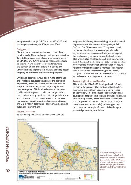
catchment. An example of a map of the change in<br />
perennial pasture is given below.<br />
A complete loss of perennial<br />
pasture is shown as bright red.<br />
Inversely a new area of perennial<br />
pasture in the 2003-2004 season<br />
is shown as bright green. Light<br />
orange <strong>and</strong> light green are areas<br />
of relative stability during the time<br />
frame.