Water, Land and People - Goulburn Broken Catchment ...
Water, Land and People - Goulburn Broken Catchment ...
Water, Land and People - Goulburn Broken Catchment ...

Create successful ePaper yourself
Turn your PDF publications into a flip-book with our unique Google optimized e-Paper software.
Bird hides for Gemmill’s Swamp were constructed<br />
under the Drought Employment Program.<br />
A number of priority wetl<strong>and</strong>s have been fenced to<br />
improve management.<br />
Priority wetl<strong>and</strong>s in the <strong>Catchment</strong> have been<br />
identified, based on their conservation significance<br />
<strong>and</strong> threats, to inform resource decision-making<br />
<strong>and</strong> guide the allocation of limited resources.<br />
A Wetl<strong>and</strong> Implementation Plan for lower <strong>Broken</strong><br />
to <strong>Goulburn</strong> River commenced.<br />
The Kanyapella Wetl<strong>and</strong> Management Plan was<br />
completed. This will assist l<strong>and</strong>owners <strong>and</strong> agencies<br />
identify weeds.<br />
Environmental Flows<br />
Given the potential for severe drought in 2007-<br />
2008, the GB CMA participated in planning how<br />
to share the potentially very limited available<br />
water. This included preparing a GB CMA dry<br />
inflow contingency plan which identified the critical<br />
environmental assets that needed to be protected<br />
under a survival scenario.<br />
Expert advice was obtained on the potential<br />
impacts of low flows on the <strong>Goulburn</strong> River<br />
below <strong>Goulburn</strong> Weir as part of the dry inflow<br />
contingency planning.<br />
A study into the environmental implications of<br />
high summer flows in the <strong>Goulburn</strong> River below<br />
<strong>Goulburn</strong> Weir was completed, setting limits to<br />
flows for different environmental impacts <strong>and</strong> levels<br />
of risk.<br />
A review of the Lower <strong>Goulburn</strong> <strong>Water</strong>way Plan<br />
<strong>and</strong> a review of the Kialla Streams Plan were<br />
completed.<br />
Studies were conducted on:<br />
• constraints to delivery of environmental<br />
flows in the <strong>Goulburn</strong> River <strong>and</strong> to the<br />
River Murray, finding that flooding <strong>and</strong><br />
high summer river flows were significant<br />
constraints.<br />
• the interaction between environmental<br />
flows <strong>and</strong> flooding. This included obtaining<br />
comprehensive l<strong>and</strong> surface elevation data<br />
for the <strong>Goulburn</strong> River <strong>and</strong> its floodplain.<br />
• the monitoring program to determine<br />
ecological response to environmental flow<br />
releases in the <strong>Goulburn</strong> River, <strong>Broken</strong> River<br />
<strong>and</strong> <strong>Broken</strong> Creek.<br />
The environmental condition of the <strong>Broken</strong> <strong>and</strong><br />
Boosey Creeks (as part of the assessment of<br />
the environmental impacts associated with the<br />
Tungamah Pipeline) was further benchmarked.<br />
An environmental flow determination for the<br />
upper <strong>Broken</strong> <strong>and</strong> Boosey Creeks was completed.<br />
Hydraulic modelling of flooding in the Barmah<br />
Forest progressed, with improved elevation data<br />
captured by airborne laser scanning <strong>and</strong> field<br />
surveys.<br />
Barmah Forest Environmental Management<br />
Plan<br />
In conjunction with Yorta Yorta students, a<br />
waterbird survey was carried out in Barmah Forest,<br />
resulting in the first recording of Brolga presence.<br />
The Barmah Forest Environmental Management<br />
Plan was updated, a new blueprint plan developed<br />
for future directions prepared, <strong>and</strong> a new vegetation<br />
monitoring program implemented.<br />
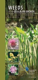
Weeds Booklet<br />
A weeds booklet was prepared to assist<br />
l<strong>and</strong>holders <strong>and</strong> agencies identify weeds which<br />
impact on the quality of riparian l<strong>and</strong>s <strong>and</strong> in-stream<br />
habitats. This information will be incorporated<br />
into the overall <strong>Goulburn</strong> <strong>Broken</strong> Weed booklet<br />
currently being reprinted as a third edition.<br />
RiverConnect - Shepparton Region<br />
A number of projects have been achieved through<br />
the RiverConnect Project including:<br />
• The GB CMA hosted 15 Australian National<br />
PROGRAM REPORTS<br />
37