AF01 Lee Valley and Finchley Ridge.pdf - Greater London Authority
AF01 Lee Valley and Finchley Ridge.pdf - Greater London Authority
AF01 Lee Valley and Finchley Ridge.pdf - Greater London Authority

Create successful ePaper yourself
Turn your PDF publications into a flip-book with our unique Google optimized e-Paper software.
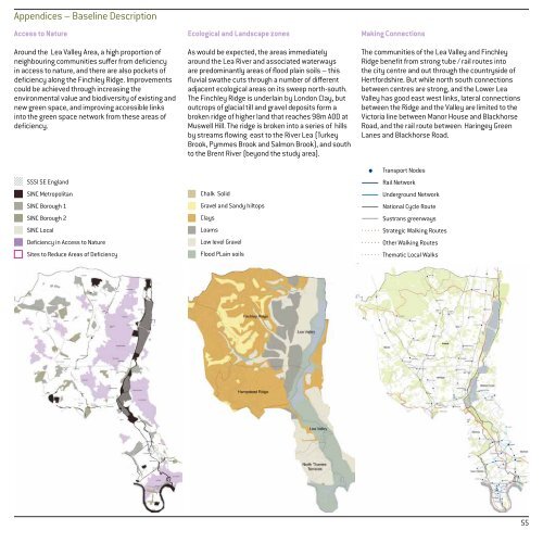
Appendices – Baseline Description<br />
Access to Nature<br />
Around the Lea <strong>Valley</strong> Area, a high proportion of<br />
neighbouring communities suffer from deficiency<br />
in access to nature, <strong>and</strong> there are also pockets of<br />
deficiency along the <strong>Finchley</strong> <strong>Ridge</strong>. Improvements<br />
could be achieved through increasing the<br />
environmental value <strong>and</strong> biodiversity of existing <strong>and</strong><br />
new green space, <strong>and</strong> improving accessible links<br />
into the green space network from these areas of<br />
deficiency.<br />
SSSI SE Engl<strong>and</strong><br />
SINC Metropolitan<br />
SINC Borough 1<br />
SINC Borough 2<br />
SINC Local<br />
Deficiency in Access to Nature<br />
Sites to Reduce Areas of Deficiency<br />
Ecological <strong>and</strong> L<strong>and</strong>scape zones<br />
As would be expected, the areas immediately<br />
around the Lea River <strong>and</strong> associated waterways<br />
are predominantly areas of flood plain soils – this<br />
fluvial swathe cuts through a number of different<br />
adjacent ecological areas on its sweep north-south.<br />
The <strong>Finchley</strong> <strong>Ridge</strong> is underlain by <strong>London</strong> Clay, but<br />
outcrops of glacial till <strong>and</strong> gravel deposits form a<br />
broken ridge of higher l<strong>and</strong> that reaches 98m AOD at<br />
Muswell Hill. The ridge is broken into a series of hills<br />
by streams flowing east to the River Lea (Turkey<br />
Brook, Pymmes Brook <strong>and</strong> Salmon Brook), <strong>and</strong> south<br />
to the Brent River (beyond the study area).<br />
Chalk Solid<br />
Gravel <strong>and</strong> S<strong>and</strong>y hiltops<br />
Clays<br />
Loams<br />
Low level Gravel<br />
Flood PLain soils<br />
Making Connections<br />
The communities of the Lea <strong>Valley</strong> <strong>and</strong> <strong>Finchley</strong><br />
<strong>Ridge</strong> benefit from strong tube / rail routes into<br />
the city centre <strong>and</strong> out through the countryside of<br />
Hertfordshire. But while north south connections<br />
between centres are strong, <strong>and</strong> the Lower Lea<br />
<strong>Valley</strong> has good east west links, lateral connections<br />
between the <strong>Ridge</strong> <strong>and</strong> the <strong>Valley</strong> are limited to the<br />
Victoria line between Manor House <strong>and</strong> Blackhorse<br />
Road, <strong>and</strong> the rail route between Haringey Green<br />
Lanes <strong>and</strong> Blackhorse Road.<br />
Transport Nodes<br />
Rail Network<br />
Underground Network<br />
National Cycle Route<br />
Sustrans greenways<br />
Strategic Walking Routes<br />
Other Walking Routes<br />
Thematic Local Walks<br />
55