(eds.) (2005). - Portal da Biodiversidade dos Açores - Universidade ...
(eds.) (2005). - Portal da Biodiversidade dos Açores - Universidade ...
(eds.) (2005). - Portal da Biodiversidade dos Açores - Universidade ...

Create successful ePaper yourself
Turn your PDF publications into a flip-book with our unique Google optimized e-Paper software.
Origem <strong>dos</strong> <strong>da</strong><strong>dos</strong> ambientais<br />
Uma base de <strong>da</strong><strong>dos</strong> espacial detalha<strong>da</strong>, incluindo<br />
informação explícita sobre a ilha Terceira, está presentemente<br />
armazena<strong>da</strong> em ambiente SIG por F. O.<br />
Dinis, J. Hortal e P. A. V. Borges, no Departamento<br />
de Ciências Agrárias <strong>da</strong> Universi<strong>da</strong>de <strong>dos</strong> <strong>Açores</strong>,<br />
utilizando o programa e formatação Idrisi (Clark<br />
Labs 2004). A resolução espacial de mapas “raster”<br />
(os que guar<strong>da</strong>m a informação para ca<strong>da</strong> um <strong>dos</strong><br />
pontos de uma janela bem defini<strong>da</strong>; ver Johnston<br />
1999) nesta base de <strong>da</strong><strong>dos</strong> SIG é de 100x100 m.<br />
Como a informação biológica foi guar<strong>da</strong><strong>da</strong> numa<br />
resolução inferior (tamanho superior <strong>da</strong> grelha),<br />
to<strong>dos</strong> os mapas <strong>da</strong> base de <strong>da</strong><strong>dos</strong> foram transforma<strong>dos</strong><br />
para uma resolução de 500x500 m (ver<br />
discussão em Hortal & Lobo 2002, <strong>2005</strong>). Foram<br />
incluí<strong>da</strong>s quatro categorias de mapas e utiliza<strong>da</strong>s<br />
nas análises posteriores:<br />
i) Um modelo de elevação digital (MED, mapa de<br />
altitudes) e mapas deriva<strong>dos</strong>. Um modelo<br />
“raster” de MED foi desenvolvido utilizando a<br />
interpolação <strong>da</strong>s curvas de altitude <strong>da</strong> carta<br />
digital <strong>dos</strong> Serviços Cartográficos do Exército.<br />
O declive e a exposição foram usa<strong>dos</strong> na criação<br />
deste mapa.<br />
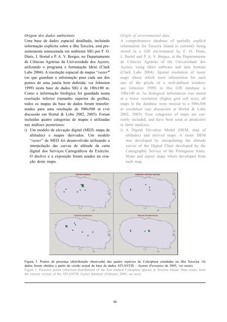
Figura 3. Pontos de presença (distribuição observa<strong>da</strong>) <strong>da</strong>s quatro espécies de Coleoptera estu<strong>da</strong><strong>da</strong>s na ilha Terceira. Os<br />
<strong>da</strong><strong>dos</strong> foram obti<strong>dos</strong> a partir <strong>da</strong> versão actual <strong>da</strong> base de <strong>da</strong><strong>dos</strong> ATLANTIS – <strong>Açores</strong> (Fevereiro de <strong>2005</strong>, ver texto).<br />
Figure 3. Presence points (observed distribution) of the four studied Coleoptera species in Terceira Island. Data comes from<br />
the current version of the ATLANTIS <strong>Açores</strong> <strong>da</strong>tabase (February <strong>2005</strong>; see text).<br />
86<br />
Origin of environmental <strong>da</strong>ta<br />
A comprehensive <strong>da</strong>tabase of spatially explicit<br />
information for Terceira Island is currently being<br />
stored in a GIS environment by F. O. Dinis,<br />
J. Hortal and P. A. V. Borges, at the Departamento<br />
de Ciências Agrárias of the Universi<strong>da</strong>de <strong>dos</strong><br />
<strong>Açores</strong>, using Idrisi software and <strong>da</strong>ta formats<br />
(Clark Labs 2004). Spatial resolution of raster<br />
maps (those which store information for each<br />
one of the píxels of a well-defined window;<br />
see Johnston 1999) in this GIS <strong>da</strong>tabase is<br />
100x100 m. As biological information was stored<br />
at a lower resolution (higher grid cell size), all<br />
maps in the <strong>da</strong>tabase were resized to a 500x500<br />
m resolution (see discussion at Hortal & Lobo<br />
2002, <strong>2005</strong>). Four categories of maps are currently<br />
included, and have been used as predictors<br />
in latter analyses:<br />
i) A Digital Elevation Model (DEM, map of<br />
altitudes) and derived maps. A raster DEM<br />
was developed by interpolating the altitude<br />
curves of the Digital Chart developed by the<br />
Cartographic Service of the Portuguese Army.<br />
Slope and aspect maps where developed from<br />
such map.